Measuring unobservable forces of nature is not an easy feat, but it can make the difference between life and death in the context of an earthquake, or the collapse of a coal mine or tunnel.
To manage the risk of such events, researchers often rely on estimating a quantity called rock stress.
“Rock stress—the amount of pressure experienced by underground layers of rock—can only be measured indirectly because you can’t see the forces that cause it,” explains Hiroki Sone, an assistant professor of civil and environmental engineering and geological engineering at the University of Wisconsin-Madison. “But instruments for estimating rock stress are difficult to use at great depths, where the temperature and pressure increase tremendously.”
Addressing this challenge, Sone and his colleagues in China and Japan have now pushed the limits of rock stress measurements that don’t require temperature-sensitive instruments to new depths, from a previous maximum of 4.5 kilometers (2.8 miles) to a whopping 7 kilometers (4.3 miles).
In a study published in July 2017 in Scientific Reports, the researchers used rocks sampled from a well bore of that depth to show that stress estimates obtained by the so-called anelastic strain recovery method were consistent with a visual analysis of borehole wall images, a reliable but often infeasible approach that requires a specialized scanner.
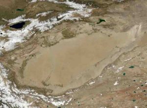
The scientists conducted their proof-of-principle study in the Tarim Basin in northwest China, an area almost two-thirds the size of Alaska that is surrounded by K2, the world’s second highest mountain after Mount Everest, and several other mountain ranges. The region is well known to historians because of its association with the Silk Road, an ancient trade route between China and the Mediterranean.
Today, in addition to historians and mountain climbers, petroleum companies have taken an interest in Tarim Basin, as it contains some of the largest oil and gas resources in Central Asia. These companies want to understand the region’s geology to assess whether drilling may trigger seismic activity, given that many smaller earthquakes have occurred in the surrounding mountains.
For Sone and his colleagues, this presented a unique opportunity to advance the methodology for measuring rock stress.
“We wanted to test the reliability of the anelastic strain recovery method at up to 7 kilometers depth because its main advantage is that you only need to sample and analyze the rock itself,” Sone says. “It estimates stress indirectly by measuring how much the rock sample expands in different directions after it has been recovered.”
With that kind of depth, the recovery process—pulling a large enough rock sample out of a borehole—can take a few days, which is why the researchers were excited to prove that the method still worked.
For the first time, they measured rock stress even when sensors weren’t attached to the sample until 65 hours after coring and found that the results matched a conventional image analysis of the borehole wall, obtained with a resistivity scanner. While the visual method also worked in this case, it can be infeasible at such great depths because of the scanner’s temperature limitations.
In addition to proving the easier method’s validity at greatly increased depth, the study resolved a longstanding geological puzzle in the Tarim Basin: The rock stress in Earth’s outer shell—which consists of many large pieces of cooler rock (tectonic plates) floating on a very thick layer of hot magma—differs between the Basin’s periphery and its interior.
Other scientists had found evidence for this difference before, but the current study confirmed it.
In the interior of Tarim Basin, tectonic plates are relatively stable, even though they crash and fold up against each other in the periphery, explaining the observed seismic activity. This translates to a lower risk of earthquakes in the interior and informs a petroleum company’s decisions about the depth at which boreholes should be stabilized to minimize the risk of structural collapse.
For earth scientists, the new study is an important validation of a more practical method for estimating rock stress. “These new results give us confidence that we can use the anelastic strain recovery method at greater depths than we thought possible,” Sone says. “As long as the rock deforms the same amount in vertical and horizontal directions, this method is much easier to apply when very high temperatures and pressures in the Earth’s crust challenge the other options in our toolbox.”
Reference:
Dongsheng Sun et al. Stress state measured at ~7 km depth in the Tarim Basin, NW China, Scientific Reports (2017). DOI: 10.1038/s41598-017-04516-9
Note: The above post is reprinted from materials provided by University of Wisconsin-Madison.


