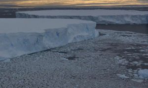
Credit: James Smith/ British Antarctic Survey
Reporting this week (Wednesday Nov. 23) in the journal Nature an international team led by British Antarctic Survey (BAS) explains that present-day thinning and retreat of Pine Island Glacier, one of the largest and fastest shrinking glaciers of the West Antarctic Ice Sheet, is part of a climate trend that was already underway as early as the 1940s.
It is already known that Pine Island Glacier—roughly two-thirds the size of the UK—has been thinning and retreating at an alarming rate since 1992 when satellite observations first started. The ice lost from this glacier and its neighbours, has added significantly to sea-level rise, and currently this area is one of biggest single unknowns in future projections. Until now, it was not known when the retreat of Pine Island Glacier started, or its underlying cause.
In this study, seabed sediment cores obtained from beneath the floating part of Pine Island Glacier have revealed that a cavity started to form beneath the shelf prior to the mid-1940s. This allowed warm sea water to flow under the shelf, and cause it to lift-off from a prominent sea-floor ridge which held it in place. This strongly suggests that current retreat was initiated by strong warming of the region associated with El Niño activity.
Lead author, marine geologist Dr James Smith from British Antarctic Survey, says:
‘We are very excited about this new finding as it provides the first direct evidence of the timing of glacier retreat even before we had satellites to measure them. The sediment cores were obtained through a 450-m deep hole in of ice, and up to 500 m of ocean. The sediment reveals climate events that initiated the current thinning of Pine Island Glacier. They show us how changes half-way across the planet in the tropical Pacific, reached through the ocean to influence the Antarctic ice sheet.
“Pine Island Glacier is one of the most inhospitable and remote areas of Antarctica, so to get all the equipment needed to hot-water drill through the ice shelf required a major effort from our collaborators at the US Antarctic Programme. On the ground it was real team effort to lower the drill by hand to the seabed on nearly 1000 m of rope. After all that work, the cores show us something so unexpected.”
Co-author and principal scientist Professor Bob Bindschadler of NASA says:
‘A significant implication of our findings is that once an ice sheet retreat is set in motion it can continue for decades, even if what started gets no worse. It is possible that the changes we see today on Pine Island Glacier were essentially set in motion in the 1940s’.
Professor David Vaughan, co-author and Director of Science at British Antarctic Survey, says:
“Ice loss from this part of West Antarctica is already making a very significant contribution to global sea level rise, and is actually one of the largest uncertainties in global sea-level predictions. Understanding what initiated the current changes is one major piece of the jigsaw, and now we are already looking for the next—how long will these changes continue and how much ice will Pine Island Glacier and its neighbours lose in the coming century? Data from the UK science programme iSTAR will tell us even more about Pine Island Glacier, but these are big questions that need the international science community to work together.”
Reference:
J. A. Smith et al, Sub-ice-shelf sediments record history of twentieth-century retreat of Pine Island Glacier, Nature (2016). DOI: 10.1038/nature20136
Note: The above post is reprinted from materials provided by British Antarctic Survey.


 in the journal Nature an international team led by British Antarctic Survey (BAS) explains that present-day thinning)