A river delta is a landform that is formed at the mouth of a river, where the river flows into an ocean, sea, estuary, lake, or reservoir. Deltas are formed from the deposition of the sediment carried by the river as the flow leaves the mouth of the river. Over long periods of time, this deposition builds the characteristic geographic pattern of a river delta.
Contrary to popular belief, this usage of the word delta was not coined by Herodotus
Formation of Delta
River deltas form when a river carrying sediment reaches either (1) a body of standing water, such as a lake, ocean, or reservoir, (2) another river that cannot remove the sediment quickly enough to stop delta formation, or (3) an inland region where the water spreads out and deposits sediments. When the flow enters the standing water, it is no longer confined to its channel and expands in width. This flow expansion results in a decrease in the flow velocity, which diminishes the ability of the flow to transport sediment. As a result, sediment drops out of the flow and deposits. Over time, this single channel will build a deltaic lobe (such as the bird’s-foot of the Mississippi or Ural River deltas), pushing its mouth further into the standing water. As the deltaic lobe advances, the gradient of the river channel becomes lower because the river channel is longer but has the same change in elevation (see slope). As the slope of the river channel decreases, it becomes unstable for two reasons. First, the water under the force of gravity will tend to flow in the most direct course down slope. If the river breaches its natural levees (i.e., during a flood), it will spill out onto a new course with a shorter route to the ocean, thereby obtaining a more stable steeper slope. Second, as its slope gets lower, the amount of sheer stress on the bed will decrease, which will result in deposition of sediment within the channel and a rise in the channel bed relative to the floodplain. This will make it easier for the river to breach its levees and cut a new channel that enters the body of standing water at a steeper slope. Often when the channel does this, some of its flow can remain in the abandoned channel. When these channel switching events occur a mature delta will gain a distributary network.
Another way in which these distributary networks may form is from the deposition of mouth bars (mid-channel sand and/or gravel bars at the mouth of a river). When this mid-channel bar is deposited at the mouth of a river, the flow is routed around it. This results in additional deposition on the upstream end of the mouth-bar, which splits the river into two distributary channels. A good example of the result of this process is the Wax Lake Delta in Louisiana.
In both of these cases, depositional processes force redistribution of deposition from areas of high deposition to areas of low deposition. This results in the smoothing of the planform (or map-view) shape of the delta as the channels move across its surface and deposit sediment. Because the sediment is laid down in this fashion, the shape of these deltas approximates a fan. It is closer to an ideal fan the more often the flow changes course because more rapid changes in channel position results in more uniform deposition of sediment on the delta front. The Mississippi and Ural River deltas, with their bird’s-feet, are examples of rivers that do not avulse often enough to form a symmetrical fan shape. Alluvial fan deltas, as seen in their name, avulse frequently and more closely approximate an ideal fan shape.
Types of Deltas
Wave-dominated deltas

Tide-dominated deltas
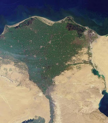
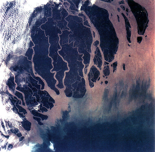
Erosion is also an important control in tide dominated deltas, such as the Ganges Delta, which may be mainly submarine, with prominent sand bars and ridges. This tends to produce a “dendritic” structure. Tidal deltas behave differently from river- and wave-dominated deltas, which tend to have a few main distributaries. Once a wave- or river- distributary silts up, it is abandoned, and a new channel forms elsewhere. In a tidal delta, new distributaries are formed during times when there’s a lot of water around – such as floods or storm surges. These distributaries slowly silt up at a pretty constant rate until they fizzle out.
Gilbert deltas
A Gilbert delta (named after Grove Karl Gilbert) is a specific type of delta that is formed by coarse sediments, as opposed to gently-sloping muddy deltas such as that of the Mississippi. For example, a mountain river depositing sediment into a freshwater lake would form this kind of delta.While some authors describe both lacustrine and marine locations of Gilbert deltas, others note that their formation is more characteristic of the freshwater lakes, where it is easier for the river water to mix with the lakewater faster (as opposed to the case of a river falling into the sea or a salt lake, where less dense fresh water brought by the river stays on top longer).
G.K. Gilbert himself first described this type of delta on Lake Bonneville in 1885.Elsewhere, similar structures can be found e.g. at the mouths of several creeks flowing into Okanagan Lake in British Columbia and forming prominent peninsulas at Naramata (49°35′30″N 119°35′30″W), Summerland (49°34′23″N 119°37′45″W), or Peachland (49°47′00″N 119°42′45″W)
Estuaries
Other rivers, particularly those located on coasts with significant tidal range, do not form a delta but enter into the sea in the form of an estuary. Notable examples include the Saint Lawrence River and the Tagus estuary.
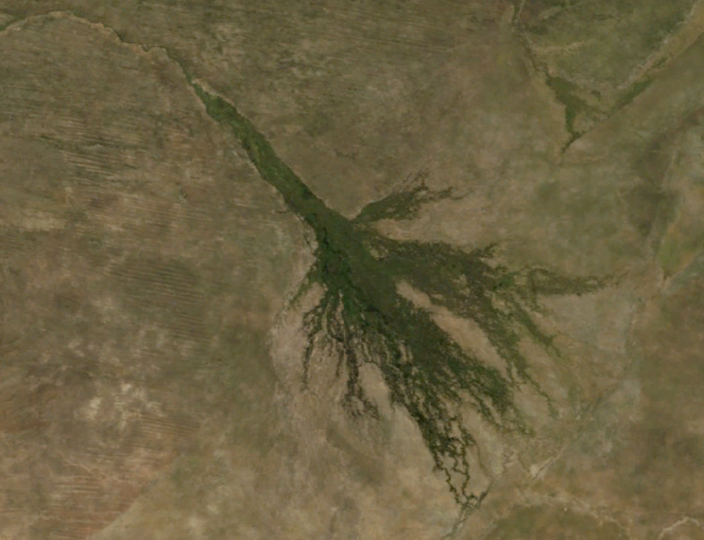
Inland deltas
In rare cases the river delta is located inside a large valley and is called an inverted river delta. Sometimes a river will divide into multiple branches in an inland area, only to rejoin and continue to the sea; such an area is known as an inland delta, and often occur on former lake beds. The Inner Niger Delta and Peace–Athabasca Delta are notable examples. The Amazon has also an inland delta before the island of Marajó.
In some cases a river flowing into a flat arid area splits into channels which then evaporate as it progresses into the desert. Okavango Delta in Botswana is one well-known example.
Sedimentary structure
The formation of a delta consists of three main forms: the topset, foreset/frontset, and bottomset.
- The bottomset beds are created from the suspended sediment that settles out of the water as the river flows into the body of water and loses energy. The suspended load is carried out the furthest into the body of water than all other types of sediment creating a turbidite. These beds are laid down in horizontal layers and consist of smaller grains.
- The foreset beds in turn build over the bottomset beds as the main delta form advances. The foreset beds consist of the bed load that the river is moving along which consists of larger sediments that roll along the main channel. When it reaches the edge of the form, the bed load rolls over the edge, and builds up in steeply angled layers over the top of the bottomset beds. The angle of the outermost edge of the delta is created by the sediments angle of repose. As the foresets build outward (which make up the majority of the delta) they pile up and miniature landslides occur. This slope is created in this fashion as the bedload continues to be deposited and the delta moves outward. In cross section, one would see the foresets lying in angled, parallel bands, showing each stage of the creation of the delta.
- The topset beds in turn overlay the foresets, and are horizontal layers of smaller sediment size that form as the main channel of the river shifts elsewhere and the larger particles of the bed load no longer are deposited. As the channels move across the top of the delta, the suspended load settles out in horizontal beds over the top. The topset bed is subdivided into two regions: the upper delta plain and the lower delta plain. The upper delta plain is unaffected by the tide, while the boundary with the lower delta plain is defined by the upper limit of tidal influence
Deltas and alluvial fans
Examples of notable deltas
Ecological threats to deltas
Deltas in the economy


