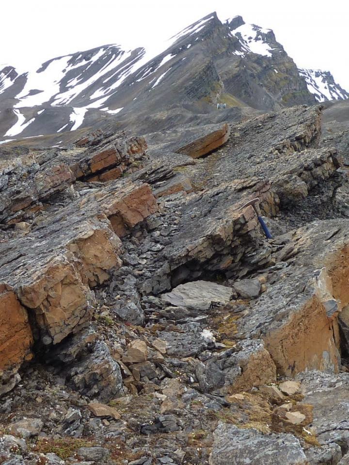
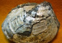
This is the Kapp Starostin Formation, Festningen section, Spitsbergen. The uppermost of the 3 yellow limestone beds records the Middle Permian mass extinction. This is the first high latitude record of this crisis, which is now seen to be of global extent. The photo, from Isfjorden, Spitsbergen, was taken by Dierk Blomeier. Credit : Dierk Blomeier. For David P.G. Bond and colleagues, GSA Bulletin, 2015.
Since the Cambrian Explosion, ecosystems have suffered repeated mass extinctions, with the “Big 5” crises being the most prominent. Twenty years ago, a sixth major extinction was recognized in the Middle Permian (262 million years ago) of China, when paleontologists teased apart losses from the “Great Dying” at the end of the period. Until now, this Capitanian extinction was known only from equatorial settings, and its status as a global crisis was controversial.
David P.G. Bond and colleagues provide the first evidence for severe Middle Permian losses amongst brachiopods in northern paleolatitudes (Spitsbergen). Their study shows that the Boreal crisis coincided with an intensification of marine oxygen depletion, implicating this killer in the extinction scenario.
The widespread loss of carbonates across the Boreal Realm also suggests a role for acidification. The new data cements the Middle Permian crisis’s status as a true “mass extinction.” Thus the “Big 5” extinctions should now be considered the “Big 6.”
Reference:
David P.G. Bond et al., University of Hull, Hull, UK. Published online ahead of print on 14 Apr. 2015; DOI: 10.1130/B31216.1
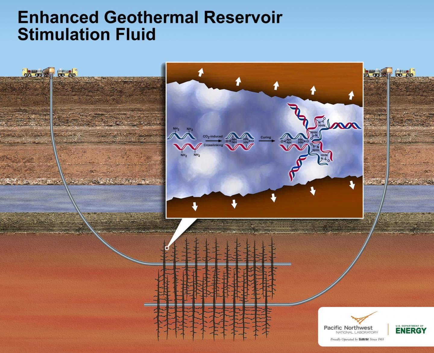
Pacific Northwest National Laboratory’s new geothermal stimulation fluid could make geothermal power production more environmentally friendly and less costly where conventional geothermal doesn’t work. The nontoxic fluid is designed to be used in enhanced geothermal systems, where fluids are injected into drilled wells that lead to underground geothermal reservoirs. The fluid expands when exposed to carbon dioxide underground, which creates tiny, but deep cracks in otherwise impermeable rock. Credit: Pacific Northwest National Laboratory
More American homes could be powered by the earth’s natural underground heat with a new, nontoxic and potentially recyclable liquid that is expected to use half as much water as other fluids used to tap into otherwise unreachable geothermal hot spots.
The fluid might be a boon to a new approach to geothermal power called enhanced geothermal systems. These systems pump fluids underground, a step that’s called “reservoir stimulation,” to enable power production where conventional geothermal doesn’t work.
The new reservoir stimulation fluid features an environmentally friendly polymer that greatly expands the fluid’s volume, which creates tiny cracks in deep underground rocks to improve power production. This fluid could also substantially reduce the water footprint and cost of enhanced geothermal systems. A paper describing the fluid has been published by the Royal Society of Chemistry in an advance online version of the journal Green Chemistry.
“Our new fluid can make enhanced geothermal power production more viable,” said lead fluid developer Carlos Fernandez, a chemist at the Department of Energy’s Pacific Northwest National Laboratory. “And, though we initially designed the fluid for geothermal energy, it could also make unconventional oil and gas recovery more environmentally friendly.”
Natural power beneath us
Geothermal power is generated by tapping the heat that exists under the Earth’s surface to extract steam and turn power plant turbines. Conventional geothermal power plants rely on the natural presence of three things: underground water, porous rock and heat. Existing U.S. geothermal power plants generate up to 3.4 gigawatts of energy, making up about 0.4 percent of the nation’s energy supply.
Enhanced geothermal power can be generated at sites where heat exists, but isn’t easily accessible because of impermeable rock or insufficient water. A 2006 report led by the Massachusetts Institute of Technology estimates enhanced geothermal systems could boost the nation’s geothermal energy output 30-fold to more than 100 gigawatts, or enough to power 100 million typical American homes.
Interested in this potential, DOE has funded five enhanced geothermal system demonstration projects across the country. At one demonstration project in Nevada, enhanced geothermal methods increased a conventional geothermal plant’s productivity by 38 percent. But the use of enhanced geothermal systems has been limited due to technical challenges and concerns over their cost and heavy use of water.
Creating enhanced geothermal systems requires injecting millions of gallons of water – a valuable resource in the arid American West, where enhanced geothermal has the most potential. That water is sometimes mixed with a very small amount of chemicals to help the fluid better create and spread tiny cracks underground, which ultimately extends the life of a geothermal power plant.
Some geothermal reservoir stimulation fluids are similar to oil and gas hydraulic fracturing fluids in that a small percentage of their volume can include proprietary chemicals, according to a 2009 paper in Geothermics and other sources. These chemicals can be toxic if ingested, leading geothermal developers to retrieve and treat used fluids. This protects aquifers, but increases the cost of power generation as well. Environmental reviews must be conducted to receive permits for enhanced geothermal injections.
A better solution
PNNL’s fluid is a solution of water and 1 percent polyallylamine, a chemical made of a long carbon chain with nitrogen attachments that’s similar to well-understood polymers used in medicine. The fluid is pumped into a well drilled at a geothermal hot spot. Soon after, workers also inject pressurized carbon dioxide, which could come from carbon captured at fossil fuel power plants.
Within 20 seconds, the polyallylamine and carbon dioxide link together to form a hydrogel that expands the fluid up to 2.5 times its original volume. The swelling gel pushes against the rocks, causing existing cracks to expand while also creating new ones. The expansion is expected to cut in half the amount of water and time needed to open up an enhanced geothermal reservoir, which shrinks the cost of power generation.
Passing the test
To test the fluid’s performance, geophysicist and co-author Alain Bonneville led the development of an experimental set up. Five cylindrical samples of rocks, about the size of C batteries, taken near a working enhanced geothermal power plant in California, were placed inside a high-pressure, high-temperature test cell created by the PNNL team. Small amounts of the fluid and liquid carbon dioxide were injected into the test cell. Pressure and temperature were gradually adjusted to match the conditions of underground geothermal reservoirs.
The researchers found their fluid consistently created small, but effective cracks in rock samples. Some of the new fractures were too small to be seen with a high-resolution imaging method called X-ray microtomography. But when they watched fluids such as water or carbon dioxide being injected, the team saw liquids moving through the previously impermeable rock samples. Moving liquids did not pass through rock samples that were injected with plain water or the common hydraulic fracturing chemicals sodium dodecyl sulfate and xanthan gum. The team reasoned larger-scale tests might produce bigger cracks.
Reduce, reuse & recycle
Two other benefits are the fluid’s potential to be recycled and cut costs. The fluid could be recycled by reducing or stopping the fluids that are pumped underground, or by injecting an acid. Modeling shows either would cause the hydrogel to disassemble into its original components: the water-polyallylamine solution and carbon dioxide. A pump would move the separated fluids to the surface, where they would be retrieved and used again. The fluid’s recyclability hasn’t been tested in the lab yet, however.
The operational cost of enhanced geothermal systems could also be reduced with the new fluid. With less liquid to pump underground, there will be less water to purchase, capture and treat, which lowers project costs. However, a detailed analysis is needed to precisely quantify by how much the fluid could lower enhanced geothermal’s price tag.
Additional studies are needed to further evaluate the fluid’s performance for enhanced geothermal systems. Fernandez and his team are planning lab studies to examine the fluid’s recyclability and its ability to fracture larger pieces of rock. Their ultimate goal is to conduct a controlled field test.
The Geothermal Technologies Office within the Department of Energy’s Office of Energy Efficiency and Renewable Energy funded this research. This study used X-ray computed tomography and magic angle spinning nuclear magnetic resonance instruments at EMSL, the Environmental Molecular Sciences Laboratory DOE user facility at PNNL.
The team also recently started a PNNL-funded study to examine a similar fluid for unconventional oil and gas recovery. The oil and gas extraction fluid being considered would use a different polyamine that is related to the chemical used in the geothermal extraction fluid. Both fluids are stable and can withstand extreme temperatures, pressures and acidity levels. Many of the fluids used for oil and gas recovery degrade, making them less effective over time. That characteristic, combined with the fluid’s decreased water use, its nontoxic nature and its potential to be recycled, makes the PNNL fluid a candidate for oil and gas extraction.
Video
Reference:
HB Jung, KC Carroll, S Kabilan, DJ Heldebrant, D Hoyt, L Zhong, T Varga, S Stephens, L Adams, A Bonneville, A Kuprat & CA Fernandez, “Stimuli-responsive/rheoreversible hydraulic fracturing fluids as a greener alternative to support geothermal and fossil energy production,” Green Chemistry Advance Online, March 25, 2015, DOI: 10.1039/C4GC01917B
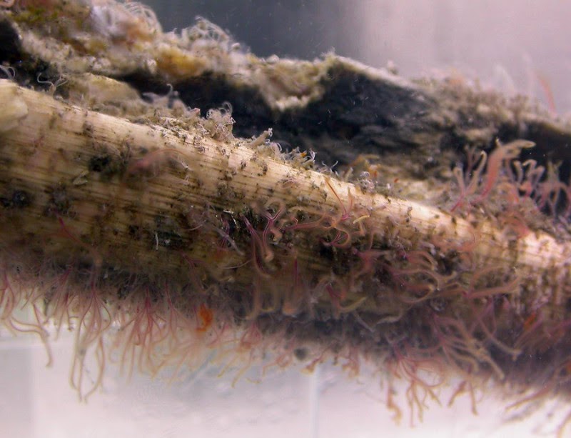
Research reveals fossil record may have been impacted by the appetite of Osedax. Credit: Image copyright Nicholas Higgs, courtesy of University of Plymouth
A species of bone-eating worm that was believed to have evolved in conjunction with whales has been dated back to prehistoric times when it fed on the carcasses of giant marine reptiles.
Scientists at Plymouth University found that Osedax — popularised as the ‘zombie worm’ — originated at least 100 million years ago, and subsisted on the bones of prehistoric reptiles such as plesiosaurs and sea turtles.
Reporting in the Royal Society journal Biology Letters this month, the research team at Plymouth reveal how they found tell-tale traces of Osedax on plesiosaur fossils held in the Sedgwick Museum at the University of Cambridge.
Dr Nicholas Higgs, a Research Fellow in the Marine Institute, said the discovery was important for both understanding the genesis of the species and its implications for fossil records. “The exploration of the deep sea in the past decades has led to the discovery of hundreds of new species with unique adaptations to survive in extreme environments, giving rise to important questions on their origin and evolution through geological time.” said Nicholas. “The unusual adaptations and striking beauty of Osedax worms encapsulate the alien nature of deep-sea life in public imagination.
“And our discovery shows that these bone-eating worms did not co-evolve with whales, but that they also devoured the skeletons of large marine reptiles that dominated oceans in the age of the dinosaurs. Osedax, therefore, prevented many skeletons from becoming fossilised, which might hamper our knowledge of these extinct leviathans.”
The finger-length Osedax is found in oceans across the globe at depths of up to 4,000m, and it belongs to the Siboglinidae family of worms, which, as adults, lack a mouth and digestive system. Instead, they penetrate bone using root-like tendrils through which they absorb bone collagen and lipids that are then converted into energy by bacteria inside the worm.
Typically they consume whale bones, prompting many scientists to believe that they co-evolved 45 million years ago, branching out from their cousins that used chemosysnthesis to obtain food.
But Nicholas, and research lead Dr Silvia Danise, of Plymouth’s School of Geography, Earth and Environmental Sciences, studied fossil fragments taken from a plesiosaur unearthed in Cambridge, and a sea turtle found in Burham, Kent.
Using a computed tomography scanner at the Natural History Museum — essentially a three-dimensional X-ray — they were able to create a computer model of the bones, and found tell-tale bore holes and cavities consistent with the burrowing technique of Osedax.
Dr Danise said: “The increasing evidence for Osedax throughout the oceans past and present, combined with their propensity to rapidly consume a wide range of vertebrate skeletons, suggests that Osedax may have had a significant negative effect on the preservation of marine vertebrate skeletons in the fossil record.
“By destroying vertebrate skeletons before they could be buried, Osedax may be responsible for the loss of data on marine vertebrate anatomy and carcass-fall communities on a global scale. The true extent of this ‘Osedax effect’, previously hypothesized only for the Cenozoic, now needs to be assessed for Cretaceous marine vertebrates.”
Reference:
S. Danise, N. D. Higgs. Bone-eating Osedax worms lived on Mesozoic marine reptile deadfalls. Biology Letters, 2015; 11 (4): 20150072 DOI: 10.1098/rsbl.2015.0072
Note: The above story is based on materials provided by University of Plymouth. The original article was written by Andrew Merrington.
A new analysis of the chemical make-up of meteorites has helped scientists work out when the Earth formed its layers.
The research by an international team of scientists confirmed the Earth’s first crust had formed around 4.5 billion years ago.
The team measured the amount of the rare elements hafnium and lutetium in the mineral zircon in a meteorite that originated early in the solar system.
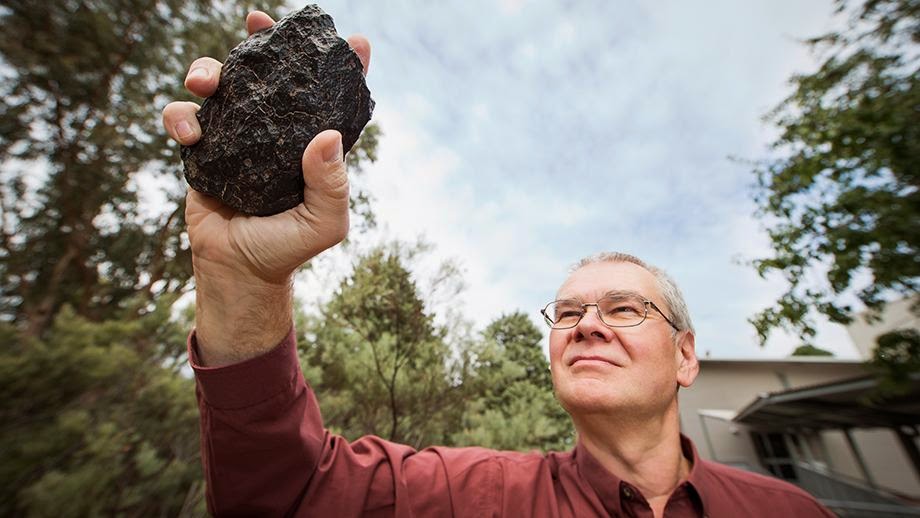
“Meteorites that contain zircons are rare. We had been looking for an old meteorite with large zircons, about 50 microns long, that contained enough hafnium for precise analysis,” said Dr Yuri Amelin, from The Australian National University (ANU) Research School of Earth Sciences.
“By chance we found one for sale from a dealer. It was just what we wanted. We believe it originated from the asteroid Vesta, following a large impact that sent rock fragments on a course to Earth.”
The heat and pressure in the Earth’s interior mixes the chemical composition of its layers over billions of years, as denser rocks sink and less dense minerals rise towards the surface, a process known as differentiation.
Determining how and when the layers formed relies on knowing the composition of the original material that formed into the Earth, before differentiation, said Dr Amelin.
“Meteorites are remnants of the original pool of material that formed all the planets,” he said.
“But they have not had planetary-scale forces changing their composition throughout their five billion years orbiting the sun.”
The team accurately measured the ratio of the isotopes hafnium-176 and hafnium-177 in the meteorite, to give a starting point for the Earth’s composition.
The team were then able to compare the results with the oldest rocks on Earth, and found that the chemical composition had already been altered, proving that a crust had already formed on the surface of the Earth around 4.5 billion years ago.
Reference:
Tsuyoshi Iizuka, Takao Yamaguchi, Yuki Hibiya, and Yuri Amelin. Meteorite zircon constraints on the bulk Lu−Hf isotope composition and early differentiation of the Earth. PNAS, April 13, 2015 DOI: 10.1073/pnas.1501658112
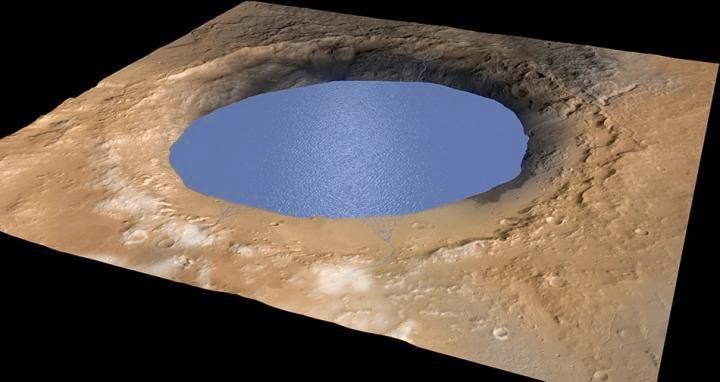
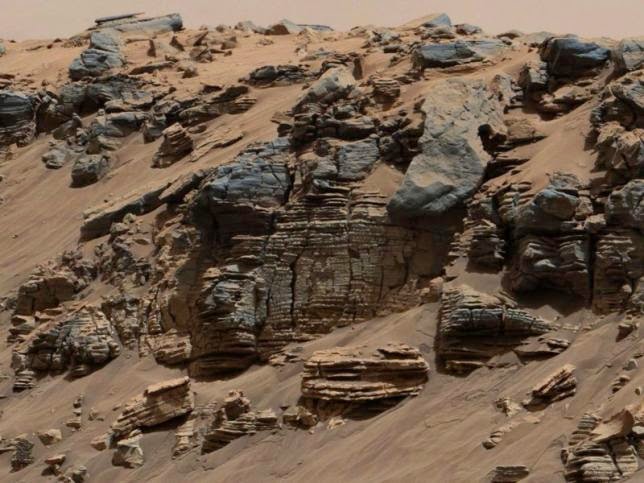
The researchers believe that Gale Crater was a large lake between 3.5 and 2.7 billion years ago. Mount Sharp, which is now an approximately five kilometer tall mountain in the middle of the crater, was probably formed by deposits from the crater and the surrounding area. Credit: NASA/JPL/Caltech/ESA/DLR/MSSS
Researchers have long known that there was water in the form of ice on Mars. Now, new research from NASA’s Mars rover Curiosity shows that it is possible that there is liquid water close to the surface of Mars. The explanation is that the substance perchlorate has been found in the soil, which lowers the freezing point so the water does not freeze into ice, but is liquid and present in very salty salt water — a brine. The results are published in the scientific journal Nature.
“We have discovered the substance calcium perchlorate in the soil and, under the right conditions, it absorbs water vapour from the atmosphere. Our measurements from the Curiosity rover’s weather monitoring station show that these conditions exist at night and just after sunrise in the winter. Based on measurements of humidity and the temperature at a height of 1.6 meters and at the surface of the planet, we can estimate the amount of water that is absorbed. When night falls, some of the water vapour in the atmosphere condenses on the planet surface as frost, but calcium perchlorate is very absorbent and it forms a brine with the water, so the freezing point is lowered and the frost can turn into a liquid. The soil is porous, so what we are seeing is that the water seeps down through the soil. Over time, other salts may also dissolve in the soil and now that they are liquid, they can move and precipitate elsewhere under the surface,” explains Morten Bo Madsen, associate professor and head of the Mars Group at the Niels Bohr Institute at the University of Copenhagen.
Riverbed and enormous lake
Observations by the Mars probe’s stereo camera have previously shown areas characteristic of old riverbed with rounded pepples that clearly show that a long time ago there was flowing, running water with a depth of up to one meter. Now the new close-up images taken by the rover all the way en route to Mount Sharp show that there are expanses of sedimentary deposits, lying as ‘plates’ one above the other and leaning a bit toward Mount Sharp.
“These kind of deposits are formed when large amounts of water flow down the slopes of the crater and these streams of water meet the stagnant water in the form of a lake. When the stream meets the surface, the solid material carried by the stream falls down and is deposited in the lake just at the lakeshore. Gradually, a slightly inclined slope is built up just below the surface of the water and traces of such slanting deposits were found during the entire trip to Mount Sharp. Very fine-grained sediments, which slowly fell down through the water, were deposited right at the very bottom of the crater lake. The sediment plates on the bottom are level, so everything indicates that the entire Gale Crater may have been a large lake,” explains Morten Bo Madsen.
He explains that about 4.5 billion years ago, Mars had 6½ times as much water as it does now and a thicker atmosphere. But most of this water has disappeared out into space and the reason is that Mars no longer has global magnetic fields, which we have on Earth.
Currents of liquid iron in the Earth’s interior generate the magnetic fields and they act as a shield that protects us from cosmic radiation. The magnetic field protects the Earth’s atmosphere against degradation from energy rich particles from the Sun. But Mars no longer has a global magnetic field and this means that the atmosphere is not protected from radiation from the Sun, so the solar particles (protons) simply ‘shoot’ the atmosphere out into space little by little.
Even though liquid water has now been found, it is not likely that life will be found on Mars — it is too dry, too cold and the cosmic radiation is so powerful that it penetrates at least one meter into the surface and kills all life — at least life as we know it on Earth.
An international team, including researchers at the University of Liverpool, have shown that south east Iceland is underlain by continental crust.
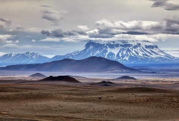
The team found that the accepted theory, that Iceland consists only of very thick oceanic crust, is incorrect. Maps of crustal thickness produced from satellite gravity data, together with geochemical, plate tectonic reconstruction and mantle plume track analysis (an upwelling of abnormally hot rock), were used to show that south east Iceland is underlain by continental crust which extends offshore to the east.
Professor Nick Kusznir, from the University’s School of Environmental Sciences, who produced the satellite data, said: “The established theory is that geological features such as Iceland, known as oceanic plateaux, are generated by the interaction of ocean-ridge sea-floor spreading with a hot mantle upwelling.
“Our results suggest that there is another critical ingredient which is the presence of fragments of continental crust. This discovery has important implications for how mantle plumes interact with plate tectonics.”
Satellite mapping
Crustal thickness mapping shows thick crust under south east Iceland of up to 30 km, which is more ‘typical’ of continental crust in comparison to much thinner crust in the surrounding ocean basins and under the rest of Iceland.
The thick crust of south east Iceland extends eastwards offshore and is interpreted as being a sliver of continental crust originally part of, but now separated from, the Jan Mayan micro-continent to the north from which it has rifted during the formation of the north east Atlantic in the last 55 million years.
Professor Kusznir added: “Global crustal thickness mapping, using gravity inversion, suggests that tectonic features, such as Iceland, formed by the interaction of mantle plumes, sea-floor spreading and micro-continent fragments, are quite common.
“Other examples include Mauritius in the Indian Ocean; the Rio Grande High in the south Atlantic; and the Canary Islands in the Central Atlantic.
“Not only is this discovery important for the science of geo-dynamics, our findings also has important implications for natural resources in these regions. Continental crust has a very different composition and history to oceanic crust and is much richer in natural resources.”
Oil and gas exploration
Crustal thickness mapping using the satellite gravity inversion methodology was developed by Professor Kusznir and has been used for locating the transition between continental and oceanic crust and micro-continents for the United Nations Convention on the Law of the Sea (UNCLOS) territorial claims and is used extensively by the hydrocarbon industry in deep water oil and gas exploration.
Reference:
Trond H. Torsvik, Hans E. F. Amundsen, Reidar G. Trønnes, Pavel V. Doubrovine, Carmen Gaina, Nick J. Kusznir, Bernhard Steinberger, Fernando Corfu, Lewis D. Ashwal, William L. Griffin, Stephanie C. Werner, Bjørn Jamtveit. Continental crust beneath southeast Iceland. Proceedings of the National Academy of Sciences, 2015; 201423099 DOI: 10.1073/pnas.1423099112
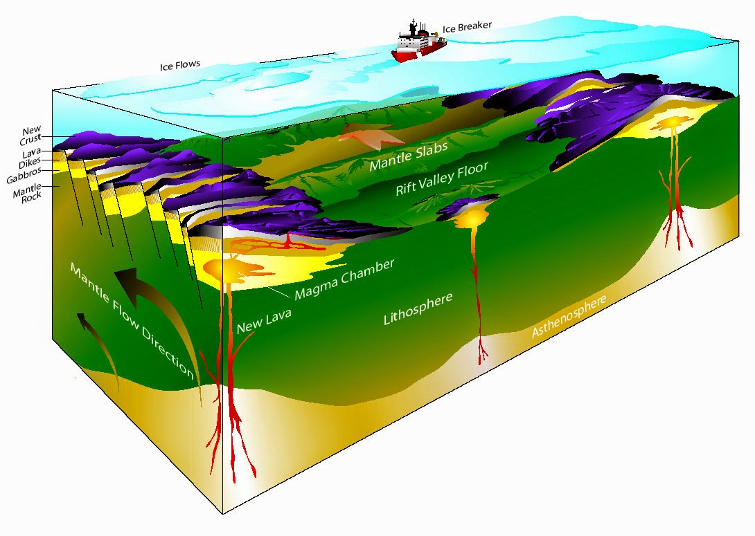
Ultra-slow spreading ocean ridges were discovered in the Arctic in 2003 by scientists at Woods Hole Ocenographic Institution. They found that for large regions the sea floor splits apart by pulling up solid rock from deep within the earth. These rocks, known as peridotites (after the gemstone peridot) come from the deep layer of the earth known as the mantle. Credit: Dr. Henry J.B. Dick, WHOI/nsf.gov
Methane, a highly effective greenhouse gas, is usually produced by decomposition of organic material, a complex process involving bacteria and microbes.
But there is another type of methane that can appear under specific circumstances: Abiotic methane is formed by chemical reactions in the oceanic crust beneath the seafloor.
New findings show that deep water gas hydrates, icy substances in the sediments that trap huge amounts of the methane, can be a reservoir for abiotic methane. One such reservoir was recently discovered on the ultraslow spreading Knipovich ridge, in the deep Fram Strait of the Arctic Ocean. The study suggests that abiotic methane could supply vast systems of methane hydrate throughout the Arctic.
The study was conducted by scientists at Centre for Arctic Gas Hydrate, Environment and Climate (CAGE) at UiT The Arctic Univeristy of Norway. The results were recently published in Geology online and will be featured in the journal´s May issue.
Previously undescribed
“Current geophysical data from the flank of this ultraslow spreading ridge shows that the Arctic environment is ideal for this type of methane production. ” says Joel Johnson associate professor at the University of New Hampshire (USA), lead author, and visiting scholar at CAGE.
This is a previously undescribed process of hydrate formation; most of the known methane hydrates in the world are fueled by methane from the decomposition of organic matter.
“It is estimated that up to 15 000 gigatonnes of carbon may be stored in the form of hydrates in the ocean floor, but this estimate is not accounting for abiotic methane. So there is probably much more.” says co-author and CAGE director Jürgen Mienert.
Life on Mars?
NASA has recently discovered traces of methane on the surface of Mars, which led to speculations that there once was life on our neighboring planet. But an abiotic origin cannot be ruled out yet.
On Earth it occurs through a process called serpentinization.
“Serpentinization occurs when seawater reacts with hot mantle rocks exhumed along large faults within the seafloor. These only form in slow to ultraslow spreading seafloor crust. The optimal temperature range for serpentinization of ocean crust is 200 – 350 degrees Celsius.” says Johnson.
Methane produced by serpentinization can escape through cracks and faults, and end up at the ocean floor. But in the Knipovich Ridge it is trapped as gas hydrate in the sediments. How is it possible that relatively warm gas becomes this icy substance?
“In other known settings the abiotic methane escapes into the ocean, where it potentially influences ocean chemistry. But if the pressure is high enough, and the subseafloor temperature is cold enough, the gas gets trapped in a hydrate structure below the sea floor. This is the case at Knipovich Ridge, where sediments cap the ocean crust at water depths up to 2000 meters. ” says Johnson.
Stable for 2 million years
Another peculiarity about this ridge is that because it is so slowly spreading, it is covered in sediments deposited by fast moving ocean currents of the Fram Strait. The sediments contain the hydrate reservoir, and have been doing so for about 2 million years.
“This is a relatively young ocean ridge, close to the continental margin,. It is covered with sediments that were deposited in a geologically speaking short time period –during the last two to three million years. These sediments help keep the methane trapped in the sea floor.” says Stefan Bünz of CAGE, also a co-author on the paper.
Bünz says that there are many places in the Arctic Ocean with a similar tectonic setting as the Knipovich ridge, suggesting that similar gas hydrate systems may be trapping this type of methane along the more than 1000 km long Gakkel Ridge of the central Arctic Ocean.
The Geology paper states that such active tectonic environments may not only provide an additional source of methane for gas hydrate, but serve as a newly identified and stable tectonic setting for the long-term storage of methane carbon in deep-marine sediments.
Need to drill
The reservoir was identified using CAGE’s high resolution 3D seismic technology aboard ice going research ressel Helmer Hanssen. Now the authors of the paper wish to sample the hydrates 140 metres below the ocean floor, and decipher their gas composition.
Knipovich Ridge is the most promising location on the planet where such samples can be taken, and one of the two locations where sampling of gas hydrates from abiotic methane is possible.
” We think that the processes that created this abiotic methane have been very active in the past. It is however not a very active site for methane release today. But hydrates under the sediment, enable us to take a closer look at the creation of abiotic methane through the gas composition of previously formed hydrate.” says Jürgen Mienert who is exploring possibilities for a drilling campaign along ultra-slow spreading Arctic ridges in the future.
Reference:
“Abiotic methane from ultraslow-spreading ridges can charge Arctic gas hydrates.” DOI: 10.1130/G36440.1
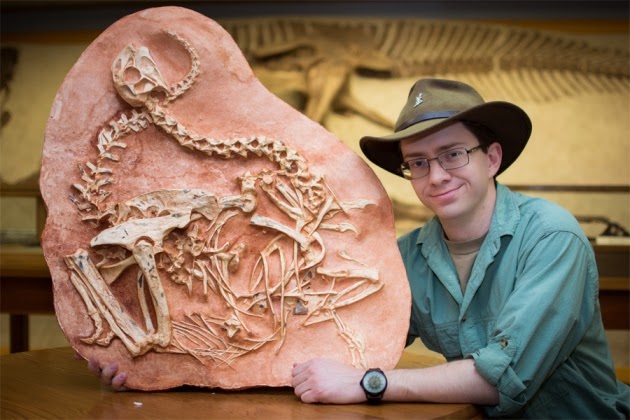
The fossil remains of two oviraptorosaurs , nicknamed ‘Romeo and Juliet’ , were reported in 2001. Credit: Amanda Kelly
Researchers think they have come up with a way to tell fossils of male dinosaurs from those of females — at least for some small feathered species. The key differences between the sexes lie in bones near the base of the tail, the scientists reported on 31 March in Scientific Reports.
The team examined a pair of fossils unearthed in Mongolia in the mid-1990s and first described in 20012. Because the turkey-sized oviraptorosaurs (“egg-thief lizards”) were found mere centimetres from each other in a 75-million-year-old rock layer, some scientists have nicknamed the pair ‘Romeo and Juliet’.
The joints in the creatures’ vertebrae were fused, so researchers think that the dinosaurs had stopped growing — meaning they were adults, says Scott Persons, a vertebrate palaeontologist at the University of Alberta in Edmonton, Canada, and a co-author of the study.
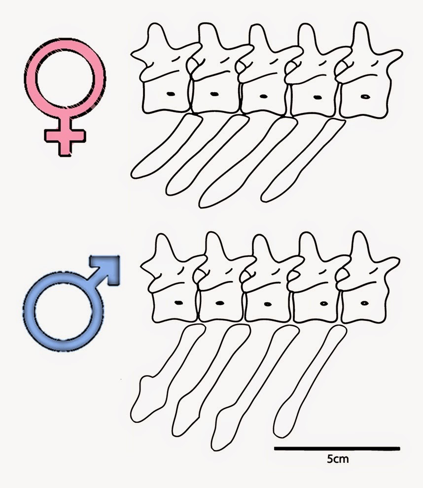
But determining whether the pair were indeed male and female was tricky, because, as with most fossils, no trace of soft tissue remains: only the bones are preserved. One fossil is a complete skeleton, whereas the other is missing the middle and end of its tail. But that was enough to reveal distinct differences in the length and shape of blade-like bones called chevrons, which jut down from the vertebrae near the base of the tail and provide attachments for muscles and tendons.
Sexy display
A number of chevrons in one of the fossils were longer and had broader tips than those in the other specimen. The differences do not seem to be due to injury or disease, says Persons. Nor do they seem to be the result of changes in the bones during fossilization.
Instead, the researchers suggest that the variations are a sign of sex differences. The bones might be shorter in females to ease the process of laying eggs. In males, a set of longer, broad-tipped chevrons could have offered a better anchor for a penis-retracting muscle that the creatures are presumed to have had.
But the most tantalizing explanation might be that males needed larger chevrons to anchor the muscles that controlled their flexible, feather-tipped tails. The researchers suspect that male oviraptorosaurs shook their tail feathers in intricate displays to woo potential mates, akin the the behaviour of modern-day peacocks.’
Two by two
The shape and size of chevron tail bones varied between the fossils that researchers tentatively identified as female (top) and male.
Thomas Holtz, a vertebrate palaeontologist at the University of Maryland in College Park, says that the theory is intriguing, but not yet totally convincing. Because the study’s authors compared only two oviraptorosaur specimens, they cannot rule out the possibility that the differences in chevron shape are merely variations on a spectrum, rather than signs of sexual dimorphism.
Analyses of other oviraptorosaur fossils should reveal whether chevrons clump into two shape groups — supporting the idea of a sex split — or come in a range of forms, says Holtz.
Confirmation of the findings could allow researchers to use chevron comparisons to determine sex in other small dinosaurs that might have used feathers for display. But Holtz says that the method would not be widely applicable to multi-tonne dinosaurs such as Tyrannosaurus rex and Triceratops.
If proved, the method would join one other technique to ascertain whether a dinosaur was male or female. In 2005, researchers noted that some T. rex fossils contain bone tissue similar to the medullary bone of modern female birds, for which it provides a short-term reservoir of calcium to produce eggshells. This method works for other large dinosaurs, but it is not foolproof because the medullary bone is only found in female specimens that are sexually mature and ready to lay eggs.
Note : The above story is based on materials provided by Nature. The original article was written by Sid Perkins.
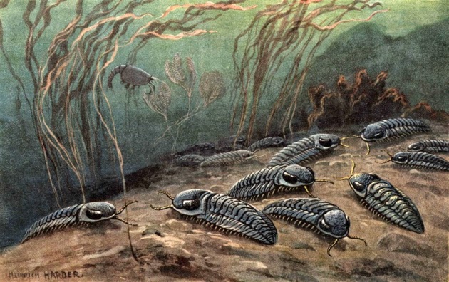
Trilobites survived for roughly 270 million years before disappearing at the end of the Permian period. Credit: Florilegius/SSPL/Getty
Earth’s greatest extinction event happened in a one-two punch 252 million years ago. Research now suggests that the second pulse of extinction, during which nearly all marine species vanished from the planet, happened in the wake of huge volcanic eruptions that spewed out carbon dioxide and made the oceans more acidic.
The work, published in Science1, is the latest to try to pinpoint the causes of the ‘Great Dying’, at the end of the Permian period. The study uses chemical evidence in rocks from that period to calculate how quickly ocean chemistry shifted.
Volcanoes in Siberia belched so much CO2 in such a short period of time that the oceans simply could not absorb it all, says team leader Matthew Clarkson, a geochemist at the University of Otago in Dunedin, New Zealand. Within just 10,000 years, pH levels in at least some of the world’s oceans plummeted.
“There was already enormous pressure on life on the oceans,” Clarkson says. “And suddenly we have what appears to be a rapid volcanic eruption, the final blow that drove the acidification.”
Reflections in the water
Today, oceans are becoming more acidic as a result of the large amounts of CO2 produced by human activities such as the burning of fossil fuels; the average pH has dropped by 0.1 units since the beginning of the Industrial Revolution. The Great Dying might represent a worst-case scenario for the future if CO2 emissions continue to rise, says Clarkson.
Other researchers have proposed all sorts of ideas for what caused the end-Permian extinction, from oxygen-starved oceans to methane-belching microbes. Top contenders have included both the Siberian volcanoes and acidifying oceans, separately or in sequence as the new study describes. In 2010, a study that examined calcium isotopes in ancient rocks found that oceans got more acidic during the end of the Permian period2.
But the latest work measures pH more directly than before, says Clarkson. His team looked at the ratios of boron isotopes in Permian-age rocks from the United Arab Emirates. Boron exists in sea-water in two forms, the relative amounts of which are controlled by how acidic or alkaline the water is. By measuring the levels of each boron isotope, the researchers could directly calculate the pH of the water that once covered the marine rocks.
The team saw little change in acid levels during the first phase of the Permian extinction, which lasted about 50,000 years. But during the second, much faster pulse, pH levels dropped by about 0.7 units over 10,000 years, Clarkson says.
That is probably because the Siberian volcanoes were putting out so much CO2 so quickly, the researchers argue. “It’s such a rapid change, the ocean can’t buffer the CO2 increase,” Clarkson says.
Many questions remain. The team cannot explain definitively what caused the first phase of extinction, which seems to have happened before the volcanoes began to erupt. And the researchers need to confirm whether Permian marine rocks in other parts of the world — not just those in the United Arab Emirates — also show the same sharp ocean acidification during the second extinction pulse.
“We’ve still got quite a lot of work to do,” says Clarkson. “Everyone always wants the smoking gun for these things.”
Andy Ridgwell, an earth systems scientist at the University of Bristol, agrees. “In principle the approach is good,” he says. “But there may be different explanations for what they’re seeing.” The end of the Permian was so geochemically complicated, he says, that untangling the various factors may take some time yet.
An evenly-layered rock on the planet Mars, photographed by the Mast Camera (Mastcam) on NASA’s Curiosity Mars Rover is shown in the NASA handout provided December 9, 2014. Credit: Reuters/NASA/JPL-Caltech/MSSS/Handout via Reuters
Mars has thousands of glaciers buried beneath its dusty surface, enough frozen water to blanket the planet with a 3.6-foot(1.1- meter) thick layer of ice, scientists said on Wednesday.
The glaciers are found in two bands in the mid-southern and mid-northern latitudes. Radar data, collected by Mars-orbiting satellites, combined with computer models of ice flows show the planet has about 5.3 trillion cubic feet (150 billion cubic meters) of water locked in the ice, according to a study published in this week’s issue of the journal Geophysical Research Letter.
“The ice at the mid-latitudes is therefore an important part of Mars’ water reservoir,” Nanna Bjornholt Karlsson, a researcher at the University of Copenhagen’s Neils Bohr Institute, said in a statement.
Scientists have been trying to figure out how Mars transformed from a warm, wet and presumably Earth-like planet early in its history into the cold, dry desert that exists today.
Billions of years ago, Mars, which lacks a protective, global magnetic field, lost much of its atmosphere. Several initiatives are under way to determine how much of the planet’s water was stripped away and how much remains locked in ice in underground reservoirs.
“The atmospheric pressure on Mars is so low that water ice simply evaporates and becomes water vapor,” the institute said in a news release.
Scientists suspect that the glaciers remained intact because they are protected under a thick layer of dust.
In addition to evidence of river beds, streams and hydrated minerals, scientists studying telltale molecules in the Martian atmosphere last month concluded that the planet probably had an ocean more than a mile deep covering almost half of its northern hemisphere. Mars has lost about 87 percent of that water, scientists said.
Currently, the planet’s largest known water reservoir is in the polar caps.
Note : The above story is based on materials provided by Reuters. The original article was Reporting by Irene Klotz; Editing by Jonathan Oatis.
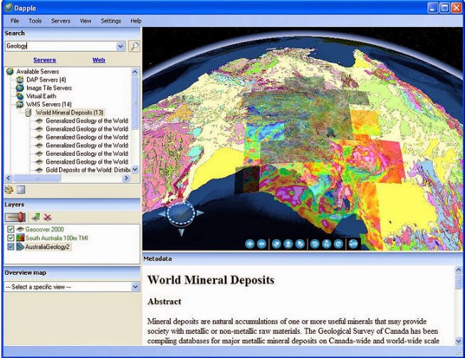
Dapple is a global data explorer designed to provide an open and optimal environment for visualizing, presenting and sharing massive quantities of geoscientific data on desktop computers. Dapple lets you browse, discover and display graphically rich data from global and corporate spatial servers – Geosoft DAP servers, NASA servers, USGS servers, and the many, many WMS servers currently available. The Dapple project is an open-source activity derived from the NASA World Wind open source project.
Geosoft’s Role in the Dapple Open Source project
Geosoft started the Dapple open source project in 2004. The Dapple project remains an open source project, however as of June 2012, Geosoft will no longer be playing an active role in the Dapple open source project.
Spatial Data Rights
When you use Dapple, you are browsing and viewing spatial data and information provided by web services on the Internet. Some of that data may be copyrighted or have other terms of use imposed by the supplier of that data. To protect your own liability, you should ensure that your use of that data does not violate any rights or conditions that the supplier of the data may have. The Dapple team shall not be liable in any way for your use of any data.
Explore the earth
Dapple makes it easy to find and visualize massive quantities of geoscientific data available on the Internet.
Search the Web for spatial data
Search internal DAP servers and known Web servers for spatial data
View geoscience data, satellite imagery, remote sensing data, geology maps, geophysical data, and many other earth data sets of interest to geoscientists
Save an earth view and share your view with colleagues
Add new Geosoft DAP, WMS and ArcIMS servers of interest
View GeoTIFF files
View KML files
Software requirements
Dapple can be installed under Windows XP SP3, Windows Vista (32,64) or Windows 7 (32,64). You must be logged in as system administrator or a power-user with rights to install software.
The Dapple installation will look for .Net Framework 2.0, then DirectX, and if either are not present on your system the Dapple install will attempt to install them for you. Should these installations prove a problem, you can choose to install these components yourself from the following reference sites:
Microsoft .Net Framework 2.0
Microsoft DirectX
You can then run the Dapple installation again.
Hardware requirements
Recommended configuration:
Operating System: Windows XP SP3, Windows Vista (32, 64), Windows 7 (32, 64).
CPU: Pentium 4 2.4GHz+ or AMD 2400xp+
System Memory (RAM): 2GB RAM
Hard Disk: Data disk space depends on the volume of project data to be processed and the printer driver you are using, however 100 GB is recommended. This is largely based on your business and data requirements.
Network Speed: 768 Kbits/sec
Graphics Card: 3D-capable with 64MB of VRAM
Screen: 1280×1024, “32-bit True Colour” screen
Screenshots
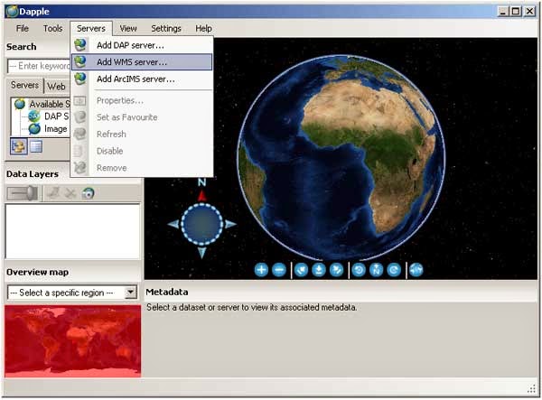
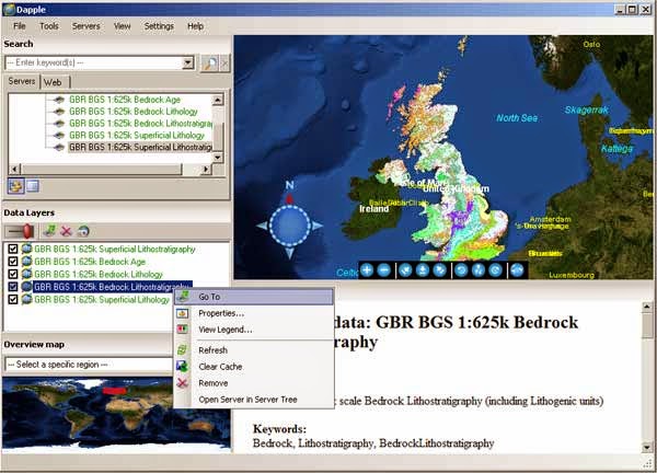
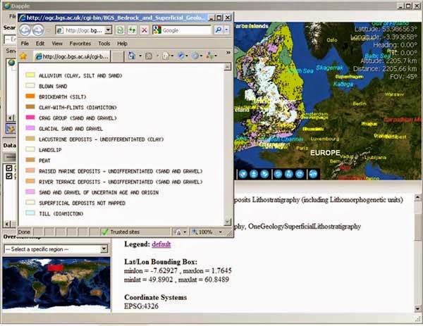
Adding a WMS server to the list of available WMS services in DappleViewing map and metadata in DappleUsing the metadata legend link to view the legend information
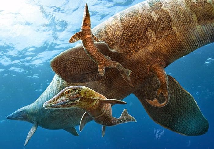
Researchers have discovered a new birth story for mosasaurs. Credit: Illustration by Julius T. Csotonyi
They weren’t in the delivery room, but researchers at Yale University and the University of Toronto have discovered a new birth story for a gigantic marine lizard that once roamed the oceans.
Thanks to recently identified specimens at the Yale Peabody Museum of Natural History, paleontologists now believe that mighty mosasaurs — which could grow to 50 feet long — gave birth to their young in the open ocean, not on or near shore.
The findings answer long-held questions about the initial environment of an iconic predator that lived during the time of the dinosaurs. Mosasaurs populated most waters of the Earth before their extinction 65 million years ago.
“Mosasaurs are among the best-studied groups of Mesozoic vertebrate animals, but evidence regarding how they were born and what baby mosasaur ecology was like has historically been elusive,” said Daniel Field, lead author of a study published online April 10 in the journal Palaeontology. Field is a doctoral candidate in the lab of Jacques Gauthier in Yale’s Department of Geology and Geophysics.
In their study, Field and his colleagues describe the youngest mosasaur specimens ever found. Field had come across the fossils in the Yale Peabody Museum’s extensive collections. “These specimens were collected over 100 years ago,” Field said. “They had previously been thought to belong to ancient marine birds.”
Field and Aaron LeBlanc, a doctoral candidate at the University of Toronto at Mississauga, concluded that the specimens showed a variety of jaw and teeth features that are only found in mosasaurs. Also, the fossils were found in deposits in the open ocean.
“Really, the only bird-like feature of the specimens is their small size,” LeBlanc said. “Contrary to classic theories, these findings suggest that mosasaurs did not lay eggs on beaches and that newborn mosasaurs likely did not live in sheltered nearshore nurseries.”
Reference:
Field, D. J., LeBlanc, A., Gau, A., Behlke, A. D. Pelagic neonatal fossils support viviparity and precocial life history of Cretaceous mosasaurs. Palaeontology, 2015 DOI: 10.1111/pala.12165
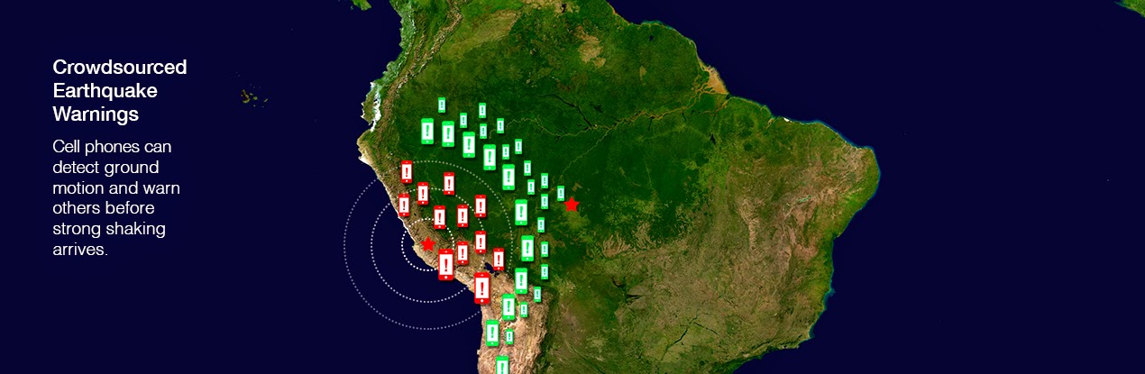
Smartphones and other personal electronic devices could, in regions where they are in widespread use, function as early warning systems for large earthquakes according to newly reported research. This technology could serve regions of the world that cannot afford higher quality, but more expensive, conventional earthquake early warning systems, or could contribute to those systems.
The study, led by scientists at the U.S. Geological Survey and published April 10 in the inaugural volume of the new AAAS journal Science Advances, found that the sensors in smartphones and similar devices could be used to build earthquake warning systems. Despite being less accurate than scientific-grade equipment, the GPS (Global Positioning System) receivers in a smartphone can detect the permanent ground movement (displacement) caused by fault motion in a large earthquake.
Using crowd-sourced observations from participating users’ smartphones, earthquakes could be detected and analyzed, and customized earthquake warnings could be transmitted back to users. “Crowd-sourced alerting means that the community will benefit by data generated from the community,” said Sarah Minson, USGS geophysicist and lead author of the study. Minson was a post-doctoral researcher at Caltech while working on this study.
Earthquake early warning systems detect the start of an earthquake and rapidly transmit warnings to people and automated systems before they experience shaking at their location. While much of the world’s population is susceptible to damaging earthquakes, EEW systems are currently operating in only a few regions around the globe, including Japan and Mexico. “Most of the world does not receive earthquake warnings mainly due to the cost of building the necessary scientific monitoring networks,” said USGS geophysicist and project lead Benjamin Brooks.
Researchers tested the feasibility of crowd-sourced EEW with a simulation of a hypothetical magnitude 7 earthquake, and with real data from the 2011 magnitude 9 Tohoku-oki, Japan earthquake. The results show that crowd-sourced EEW could be achieved with only a tiny percentage of people in a given area contributing information from their smartphones. For example, if phones from fewer than 5000 people in a large metropolitan area responded, the earthquake could be detected and analyzed fast enough to issue a warning to areas farther away before the onset of strong shaking. “The speed of an electronic warning travels faster than the earthquake shaking does,” explained Craig Glennie, a report author and professor at the University of Houston.
The authors found that the sensors in smartphones and similar devices could be used to issue earthquake warnings for earthquakes of approximately magnitude 7 or larger, but not for smaller, yet potentially damaging earthquakes. Comprehensive EEW requires a dense network of scientific instruments. Scientific-grade EEW, such as the U.S. Geological Survey’s ShakeAlert system that is currently being implemented on the west coast of the United States, will be able to help minimize the impact of earthquakes over a wide range of magnitudes. However, in many parts of the world where there are insufficient resources to build and maintain scientific networks, but consumer electronics are increasingly common, crowd-sourced EEW has significant potential.
“The U.S. earthquake early warning system is being built on our high-quality scientific earthquake networks, but crowd-sourced approaches can augment our system and have real potential to make warnings possible in places that don’t have high-quality networks,” said Douglas Given, USGS coordinator of the ShakeAlert Earthquake Early Warning System. The U.S. Agency for International Development has already agreed to fund a pilot project, in collaboration with the Chilean Centro Sismologico Nacional, to test a pilot hybrid earthquake warning system comprising stand-alone smartphone sensors and scientific-grade sensors along the Chilean coast.
“The use of mobile phone fleets as a distributed sensor network—and the statistical insight that many imprecise instruments can contribute to the creation of more precise measurements—has broad applicability including great potential to benefit communities where there isn’t an existing network of scientific instruments,” said Bob Iannucci of Carnegie Mellon University, Silicon Valley.
“Thirty years ago it took months to assemble a crude picture of the deformations from an earthquake. This new technology promises to provide a near-instantaneous picture with much greater resolution,” said Thomas Heaton, a coauthor of the study and professor of Engineering Seismology at Caltech.
“Crowd-sourced data are less precise, but for larger earthquakes that cause large shifts in the ground surface, they contain enough information to detect that an earthquake has occurred, information necessary for early warning,” said study co-author Susan Owen of NASA’s Jet Propulsion Laboratory, Pasadena, California.
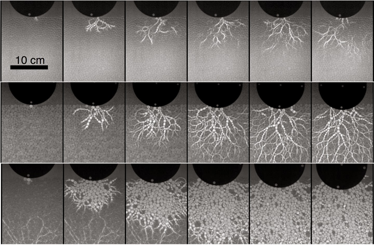
These are frames from a high-speed video of a metal object slamming into a bed of artificial soil, sand or rock. Shown at slow (top), medium (middle) and high impact speeds (bottom), the changing impact forces illuminated in each frame help explain why soil and sand get stronger when they are struck harder. Credit: Photos courtesy of Abram Clark.
When a missile or meteor strikes the earth, the havoc above ground is obvious, but the details of what happens below ground are harder to see.
Duke University physicists have developed techniques that enable them to simulate high-speed impacts in artificial soil and sand in the lab, and then watch what happens underground close-up, in super slow motion.
In a study scheduled to appear this week in the journal Physical Review Letters, they report that materials like soil and sand actually get stronger when they are struck harder.
The findings help explain why attempts to make ground-penetrating missiles go deeper by simply shooting them harder and faster have had limited success, the researchers say. Projectiles actually experience more resistance and stop sooner as their strike speed increases.
Funded by the Defense Threat Reduction Agency, the research may ultimately lead to better control of earth-penetrating missiles designed to destroy deeply buried targets such as enemy bunkers or stockpiles of underground weapons.
To simulate a missile or meteor slamming into soil or sand, the researchers dropped a metal projectile with a rounded tip from a seven-foot-high ceiling into a pit of beads.
During collision, the kinetic energy of the projectile is transferred to the beads and dissipates as they butt into each other below the surface, absorbing the force of the collision.
To visualize these forces as they move away from the point of impact, the researchers used beads made of a clear plastic that transmits light differently when compressed. When viewed through polarizing filters like those used in sunglasses, the areas of greatest stress show up as branching chains of light called “force chains” that travel from one bead to the next during impact, much like lightning bolts snaking their way across the sky.
The metal projectile fell into the beads at a speed of six meters per second, or nearly 15 miles per hour. But by using beads of varying hardness, the researchers were able to generate pulses that surged through the beads at speeds ranging from 67 to 670 miles per hour.
Each impact was too fast to see with the naked eye, so they recorded it with a high-speed video camera that shoots up to 40,000 frames per second. When they played it back in slow motion, they found that the branching network of force chains buried in the beads varied widely over different strike speeds.
At low speeds, a sparse network of beads carries the brunt of the force, said study co-author Robert Behringer, a professor of physics at Duke.
But at higher speeds, the force chains grow more extensive, which causes the impact energy to move away from the point of impact much faster than predicted by previous models.
New contacts form between the beads at high speeds as they are pressed together, and that strengthens the material.
“Imagine you’re trying to push your way through a crowded room,” said study co-author Abram Clark, currently a postdoctoral researcher in mechanical engineering at Yale University. “If you try to run and push your way through the room faster than the people can rearrange to get out of the way, you’re going to end up applying a lot of pressure and ramming into a lot of angry people.”
Video
Reference:
“Nonlinear Force Propagation During Granular Impact,” A. Clark, A. Petersen, L. Kondic and R. Behringer. Physical Review Letters, April 10. DOI: 10.1103/PhysRevLett.114.144502
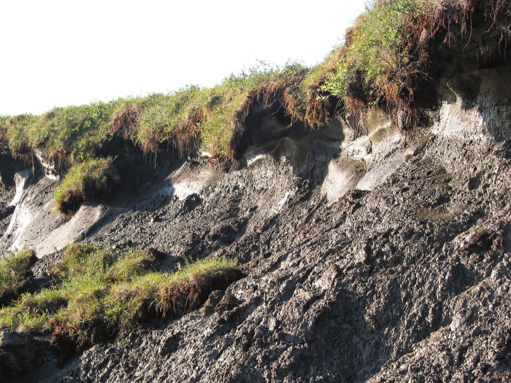
Degrading permafrost with frozen permafrost carbon and ice wedges near Noatak, Alaska. Photo by Ted Schuur
As the Earth’s climate continues to warm, researchers are working to understand how human-driven emissions of carbon dioxide will affect the release of naturally occurring greenhouse gases from arctic permafrost. As the perennially frozen soil continues to thaw, the increase of greenhouse gas emissions could significantly accelerate warming conditions changes on Earth.
An estimated 1,330 billion to 1,580 billion tons of organic carbon are stored in permafrost soils of Arctic and subarctic regions with the potential for even higher quantities stored deep in the frozen soil. The carbon is made up of plant and animal remnants stored in soil for thousands of years. Thawing and decomposition by microbes cause the release of carbon dioxide and methane greenhouse gases into the atmosphere.
“Our big question is how much, how fast and in what form will this carbon come out,” said Ted Schuur, NAU biology professor and lead author on a paper published in Nature.
The rate of carbon release can directly affect how fast climate change happens.
Schuur and fellow researchers coalesced new studies to conclude that thawing permafrost in the Artic and sub-Arctic regions will likely produce a gradual and prolonged release of substantial quantities of greenhouse gases spanning decades as opposed to an abrupt release in a decade or less.
Modern climate change is often attributed to human activities as a result of fossil fuel burning and deforestation, but natural ecosystems also play a role in the global carbon cycle. “Human activities might start something in motion by releasing carbon gases but natural systems, even in remote places like the Arctic, may add to this problem of climate change,” Schuur said. During the past 30 years, temperatures in the Arctic have increased twice as fast as other parts of the planet.
Schuur and his team of researchers from around the world also present next steps for improving knowledge of permafrost carbon and how the dynamics will affect the global carbon cycle. Approaches include improving climate change models by integrating newly created databases, changing models to differentiate between carbon and methane emissions and improved observations of carbon release from the landscape as the Arctic continues to warm.
Reference:
Climate change and the permafrost carbon feedback
E. A. G. Schuur, A. D. McGuire, C. Schädel,G. Grosse, J. W. Harden, D. J. Hayes,G. Hugelius, C. D. Koven, P. Kuhry,D. M. Lawrence, S. M. Natali, D. Olefeldt,V. E. Romanovsky, K. Schaefer, M. R. Turetsky, C. C. Treat& J. E. Vonk. DOI:10.1038/nature14338
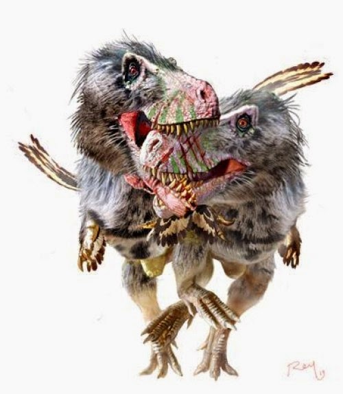
This is an artist’s reconstruction of combat between two Daspletosaurus. Credit: Copyright Luis Rey
A new study documents injuries inflicted in life and death to a large tyrannosaurine dinosaur. The paper shows that the skull of a genus of tyrannosaur called Daspletosaurus suffered numerous injuries during life, at least some of which were likely inflicted by another Daspletosaurus. It was also bitten after death in an apparent event of scavenging by another tyrannosaur. Thus there’s evidence of combat between two large carnivores as well as one feeding on another after death.
Daspletosaurus was a large carnivore that lived in Canada and was only a little smaller than its more famous cousin Tyrannosaurus. Like other tyrannosaurs it was most likely both an active predator and scavenger. The individual in question, from Alberta Canada, was not fully grown and would be considered a ‘sub-adult’ in dinosaur terms (approximately equivalent to an older teenager in human terms). It would have been just under 6 m long and around 500 kg when it died.
Researchers found numerous injuries on the skull that occurred during life. Although not all of them can be attributed to bites, several are close in shape to the teeth of tyrannosaurs. In particular one bite to the back of the head had broken off part of the skull and left a circular tooth-shaped puncture though the bone. The fact that alterations to the bone’s surface indicate healing means that these injuries were not fatal and the animal lived for some time after they were inflicted.
Lead author Dr David Hone from Queen Mary, University of London said “This animal clearly had a tough life suffering numerous injuries across the head including some that must have been quite nasty. The most likely candidate to have done this is another member of the same species, suggesting some serious fights between these animals during their lives.”
There is no evidence that the animal died at the hands (or mouth) of another tyrannosaur. However, the preservation of the skull and other bones, and damage to the jaw bones show that after the specimen began to decay, a large tyrannosaur (possibly of the same species) bit into the animal and presumably ate at least part of it.
Combat between large carnivorous dinosaurs is already known and there is already evidence for cannibalism in various groups, including tyrannosaurs. This is however an apparently unique record with evidence of both pre- and post-mortem injuries to a single individual.
Reference:
Hone and Tanke. Pre- and postmortem tyrannosaurid bite marks on the remains of Daspletosaurus (Tyrannosaurinae: Theropoda) from Dinosaur Provincial Park, Alberta, Canada. PeerJ, 2015 DOI: 10.7717/peerj.885
Note: The above story is based on materials provided by PeerJ.
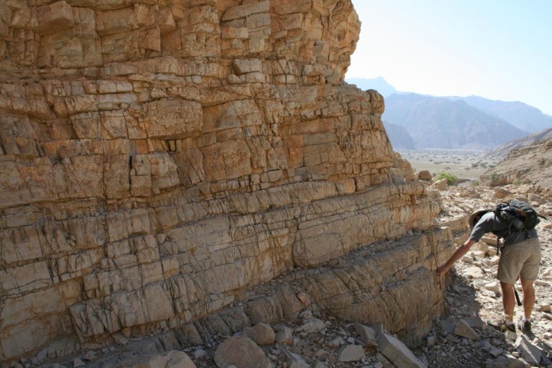
This image shows field work in the United Arab Emirates. Credit: D. Astratti
Changes to the Earth’s oceans, caused by extreme volcanic activity, triggered the greatest extinction of all time, a study suggests.
The event, which took place 252 million years ago, wiped out more than 90 per cent of marine species and more than two-thirds of the animals living on land.
It happened when Earth’s oceans absorbed huge amounts of carbon dioxide from volcanic eruptions, researchers say.
This changed the chemical composition of the oceans — making them more acidic — with catastrophic consequences for life on Earth, the team says.
The study, co-ordinated by the University of Edinburgh, is the first to show that highly acidic oceans were to blame.
The findings are helping scientists understand the threat posed to marine life by modern-day ocean acidification. The amount of carbon added to the atmosphere that triggered the mass extinction was probably greater than today’s fossil fuel reserves, the team says.
However, the carbon was released at a rate similar to modern emissions. This fast rate of release was a critical factor driving ocean acidification, researchers say.
The Permian-Triassic Boundary extinction took place over a 60,000 year period, researchers say. Acidification of the oceans lasted for around 10,000 years.
Ocean acidification was the driving force behind the deadliest phase of the extinction, which dealt a final blow to an already unstable ecosystem, researchers say. Increased temperatures and widespread loss of oxygen in the oceans had already put the environment under pressure.
Oceans can absorb some carbon dioxide but the large volume released — at such a fast rate — changed the chemistry of the oceans, the team says.
The mass extinction of both marine and land-based animals demonstrates that extreme change took place in all of Earth’s ecosystems, the team says.
The team analysed rocks unearthed in the United Arab Emirates — which were on the ocean floor at the time — to develop a climate model to work out what drove the extinction. The rocks preserve a detailed record of changing oceanic conditions at the time.
The study, published in the journal Science, was carried out in collaboration with the University of Bremen, Germany, and the University of Exeter, together with the Universities of Graz, Leeds, and Cambridge.
Funding was provided by the International Centre for Carbonate Reservoirs, Natural Environment Research Council, The Leverhulme Trust, German Research Foundation and the Marsden Fund.
Dr Matthew Clarkson, of the University of Edinburgh’s School of GeoSciences, who co-ordinated the study, said: “Scientists have long suspected that an ocean acidification event occurred during the greatest mass extinction of all time, but direct evidence has been lacking until now. This is a worrying finding, considering that we can already see an increase in ocean acidity today that is the result of human carbon emissions.”
Professor Rachel Wood, of the University of Edinburgh’s School of GeoSciences, said: “This work was highly collaborative and the results were only possible because we assembled a unique team of geochemists, geologists and modellers to tackle an important and long-standing problem.”
Reference:
M. O. Clarkson, S. A. Kasemann, R. A. Wood, T. M. Lenton, S. J. Daines, S. Richoz, F. Ohnemueller, A. Meixner, S. W. Poulton, E. T. Tipper. Ocean acidification and the Permo-Triassic mass extinction. Science, 2015 DOI: 10.1126/science.aaa0193
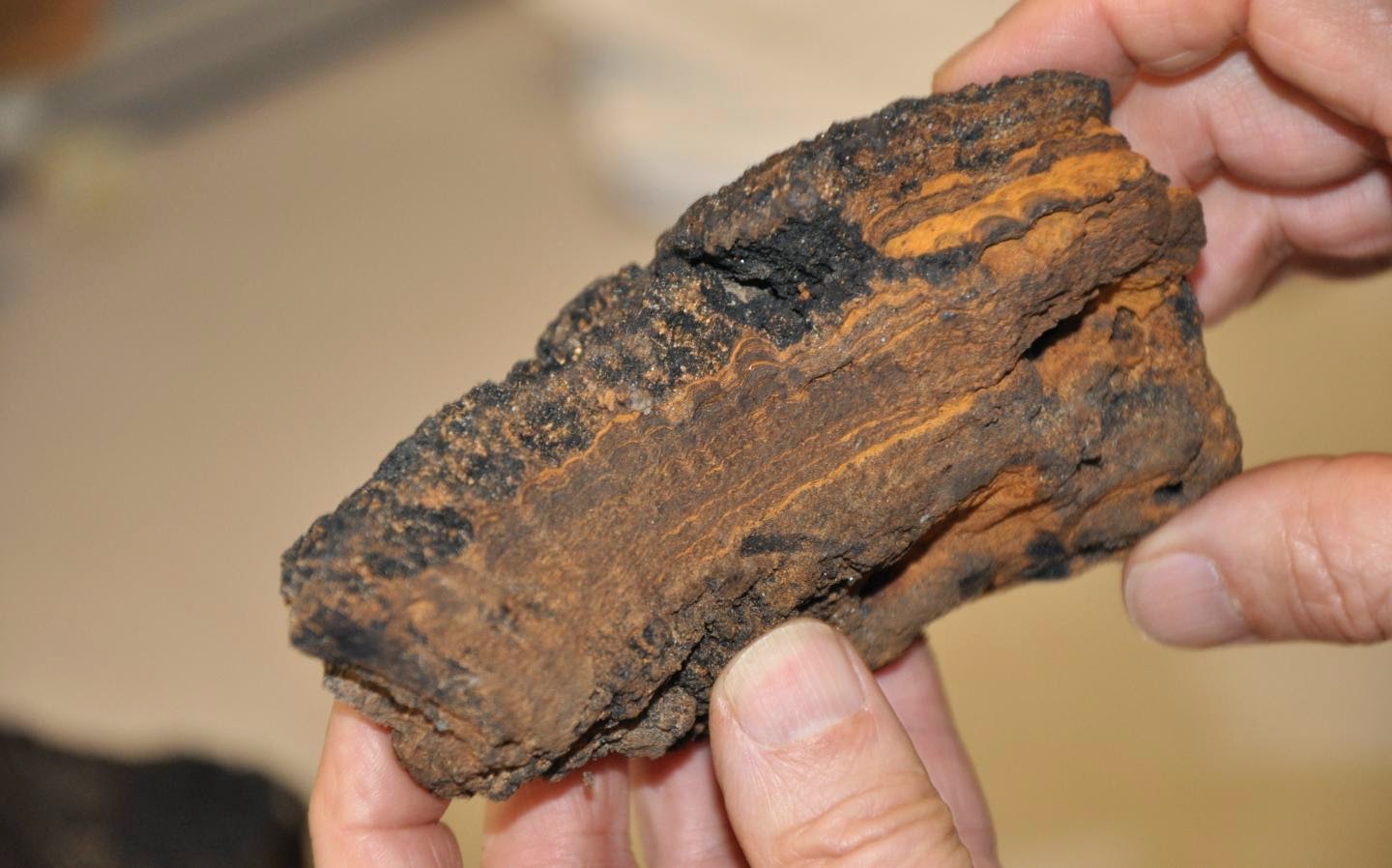
These are ferromanganese crusts with typical band structure. Credit: Source: Buczkowski, USGS.
In the past decades ferromanganese crusts have been the focus of interest due to their resource potential of valuable metals such as cobalt, nickel or rare earth elements, which are highly enriched in these crusts. For the moment, however, the cost of underwater mining outweighs their cost of recovery. Future price development will change this and deep-sea mining may one day become profitable. In their new study, the German marine scientists show that their metal content is not the only value of these crusts but that they are also archives of past climate changes.
Ferromanganese crusts are up to 26 centimeters in thickness showing laminated growth, comparable to tree rings, but on a much longer time scale. Crusts grow at incredibly slow growth rates of only a few millimeters per million years. Forming on the summit and slopes of submarine mountains these chemical sediments thus record changes in ocean chemistry reflecting the evolution of ocean currents and climate on the continents over the course of millions of years.
But how is the information stored in the crusts? The main ultimate sources of chemical substances in seawater are the rocks of the continents. Weathering erodes and dissolves the rocks and transfers the chemical components to the oceans. Some of these substances inherit the “geochemical fingerprints” of their source regions and travel around the globe together with the ocean currents. Changes in climatic conditions, such as the emergence of large-scale glaciations on the continents during the ice ages, have led to a change in the chemical composition of seawater. The huge ice shields grind the rocks more efficiently and release greater amounts of certain chemical compounds to the oceans. “This is how we can track how the conditions on glacial North America changed during the establishment of large past glaciations”, Veit Dausmann, lead author of the study, points out.
Three ferromanganese crusts from water depths between 2200 and 3600 meters were analysed in the study. The specimens are only a few centimeters thick and were recovered from the Canada Basin of the Arctic Ocean during a cruise of U.S. Coast Guard icebreaker Healy in 2005 to explore the US Exclusive Economic Zone in the Arctic Ocean. “Seven million years of the ocean’s past are archived in these crusts”, states James R. Hein, Santa Cruz-based geologist at the USGS and co-author of the study. The ages were determined using the naturally occurring radioactive isotope beryllium-10 at ETH Zurich.
The time series of the geochemical fingerprints show that due to the sluggish mixing of deep waters in the Arctic Ocean, changes in climatic conditions on land have left a particularly distinct record.
The new data show that approximately four million years ago large climatic changes started to emerge that promoted increased glaciation of North America. Since one million years ago this effect has even been amplified in response to the drastic alternations between warm and cold phases of the ice ages. “Deciphering the climatic records preserved in these ferromanganese crusts closes a large gap in our knowledge of the Arctic regions’ past” explains Martin Frank, professor at GEOMAR and co-author of the study. “Due to harsh conditions and inaccessibility of Canada Basin’s long sedimentary records, our commonly used archives of long-term climate change, have not up to now been available.”
Reference:
Dausmann, V. M. Frank, C. Siebert, M. Christl, and J. R. Hein, 2015: The evolution of climatically driven weathering inputs into the western Arctic Ocean since the late Miocene: Radiogenic isotope evidence, Earth and Planetary Science Letters, 419, 111-124, ISSN 0012-821X, DOI: 10.1016/j.epsl.2015.03.007.
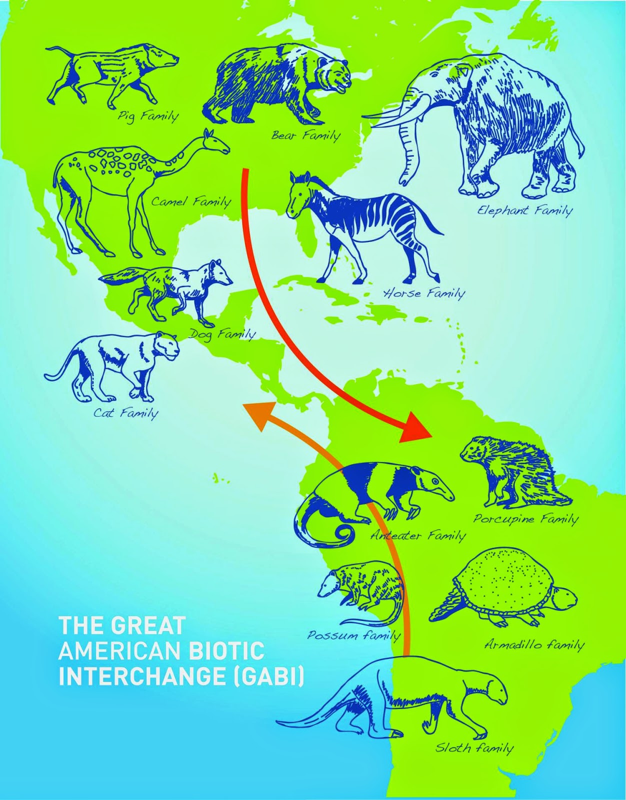
After the Isthmus of Panama formed, animals and plants could move back and forth between continents, the Great American Biological Interchange. Smithsonian scientists are debating when this happened. Credit: Smithsonian Tropical Research Institute
New evidence published in Science by Smithsonian geologists dates the closure of an ancient seaway at 13 to 15 million years ago and challenges accepted theories about the rise of the Isthmus of Panama and its impact on world climate and animal migrations.
A team analyzed zircon grains from rocks representing an ancient sea and riverbeds in northwestern South America. The team was led by Camilo Montes, former director of the Panama Geology Project at the Smithsonian Tropical Research Institute. He is now at the Universidad de los Andes.
The team’s new date for closure of the Central American Seaway, from 13 to 15 million years ago, conflicts with the widely accepted 3 million year date for the severing of all connections between the Atlantic and the Pacific, the result of work done by the Panama Paleontology Project, directed by emeritus scientists Jeremy B.C. Jackson and Anthony Coates, also at the Smithsonian Tropical Research Institute
If a land connection was complete by this earlier date, the rise of the Isthmus of Panama from the sea by tectonic and volcanic action predates the movement of animals between continents known as the Great American Biotic Interchange. The rise of the Isthmus is implicated in major shifts in ocean currents, including the creation of the Gulf Stream that led to warmer temperatures in northern Europe and the formation of a great ice sheet across North America.
“Beds younger than about 13 to 15 million years contain abundant zircon grains with a typically Panamanian age,” said Montes. “Older beds do not. We think these zircons were deposited by rivers flowing from the Isthmus of Panama when it docked to South America, nearly 10 million years earlier than the date of 3 million years that is usually given for the connection.”
The new model sends scientists like the University of Colorado at Boulder’s Peter Molnar off to look for other explanations for climate change. Molnar wrote in the journal Paleoceanography, “…let me state that the closing of the Central America Seaway seems to be no more than a bit player in global climate change. Quite likely it is a red herring.”
“What is left now is to rethink what else could have caused such dramatic global processes nearly 3 million years ago,” said Carlos Jaramillo, Smithsonian Tropical Research Institute scientist and member of the research team.
The Smithsonian Tropical Research Institute, headquartered in Panama City, Panama, is a unit of the Smithsonian Institution. The institute furthers the understanding of tropical nature and its importance to human welfare, trains students to conduct research in the tropics and promotes conservation by increasing public awareness of the beauty and importance of tropical ecosystems.
Refernce:
C. Montes, A. Cardona, C. Jaramillo, A. Pardo, J.C. Silva, V. Valencia, C. Ayala, L.C. Pérez-Angel, L.A. Rodriguez-Parra, V. Ramirez, H. Niño. 2015. Middle Miocene closure of the Central American Seaway. Science. April 10. DOI: 10.1126/science.aaa2815
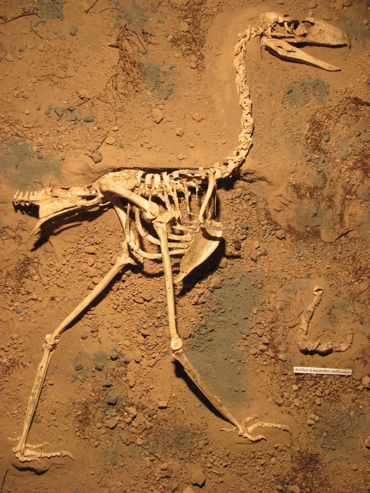
This is a skeleton of Llallawavis scagliai on display at the Museo Municipal de Ciencias Naturales Lorenzo Scaglia, Mar del Plata. Credit: M. Taglioretti and F. Scaglia.
A new species of South American fossil terror bird called Llallawavis scagliai (“Scaglia’s Magnificent Bird”) is shedding light on the diversity of the group and how these giant extinct predators interacted with their environment. The new species, described in the latest issue of the Journal of Vertebrate Paleontology, is the most complete terror bird ever discovered, with more than 90% of the skeleton exquisitely preserved. The new specimen also reveals details of anatomy that rarely preserve in the fossil record, including the auditory region of the skull, voice box, complete trachea, bones for focussing the eye, and the complete palate, allowing an unprecedented understanding of the sensory capabilities of these extinct predatory birds.
“The mean hearing estimated for this terror bird was below the average for living birds,” said Dr. Federico “Dino” Degrange, lead author of the study from the Centro de Investigaciones en Ciencias de la Tierra (CICTERRA), CONICET and the Universidad Nacional de Córdoba, Argentina. “This seems to indicate that Llallawavis may have had a narrow, low vocalization frequency range, presumably used for intraspecific acoustic communication or prey detection.” This is the first time that the structures which indicate hearing sensitivity have been reconstructed for any terror bird, and they may help explain the evolution, behavior, and ecology of this group of fossil birds.
Terror birds, or phorusracids as they are known scientifically, were carnivorous flightless birds up to 3 meters (10 ft) in height with tall hooked beaks. These birds were the predominant predators during the Cenozoic Age in South America and certainly one of the most striking groups that lived during that time. “The discovery of this new species provides new insights for studying the anatomy and phylogeny of phorusrhacids and a better understanding of this group’s diversification,” said Dr. Claudia Tambussi, also of CICTERRA and one of the co-authors of the study. The new species stood 4 feet tall and lived in Argentina approximately 3.5 million years ago in the Pliocene Epoch, towards the end of the reign of the group.
“The discovery of this species reveals that terror birds were more diverse in the Pliocene than previously thought. It will allow us to review the hypothesis about the decline and extinction of this fascinating group of birds” said Degrange.
Reference:
The Journal of Vertebrate Paleontology (JVP) is the leading journal of professional vertebrate paleontology and the flagship publication of the Society. It was founded in 1980 by Dr. Jiri Zidek and publishes contributions on all aspects of vertebrate paleontology.
Citation: Federico J. Degrange, Claudia P. Tambussi, Matías L. Taglioretti, Alejandro Dondas & Fernando Scaglia (2015): A new Mesembriornithinae (Aves, Phorusrhacidae) provides new insights into the phylogeny and sensory capabilities of terror birds, Journal of Vertebrate Paleontology, e912656. DOI: 10.1080/02724634.2014.912656