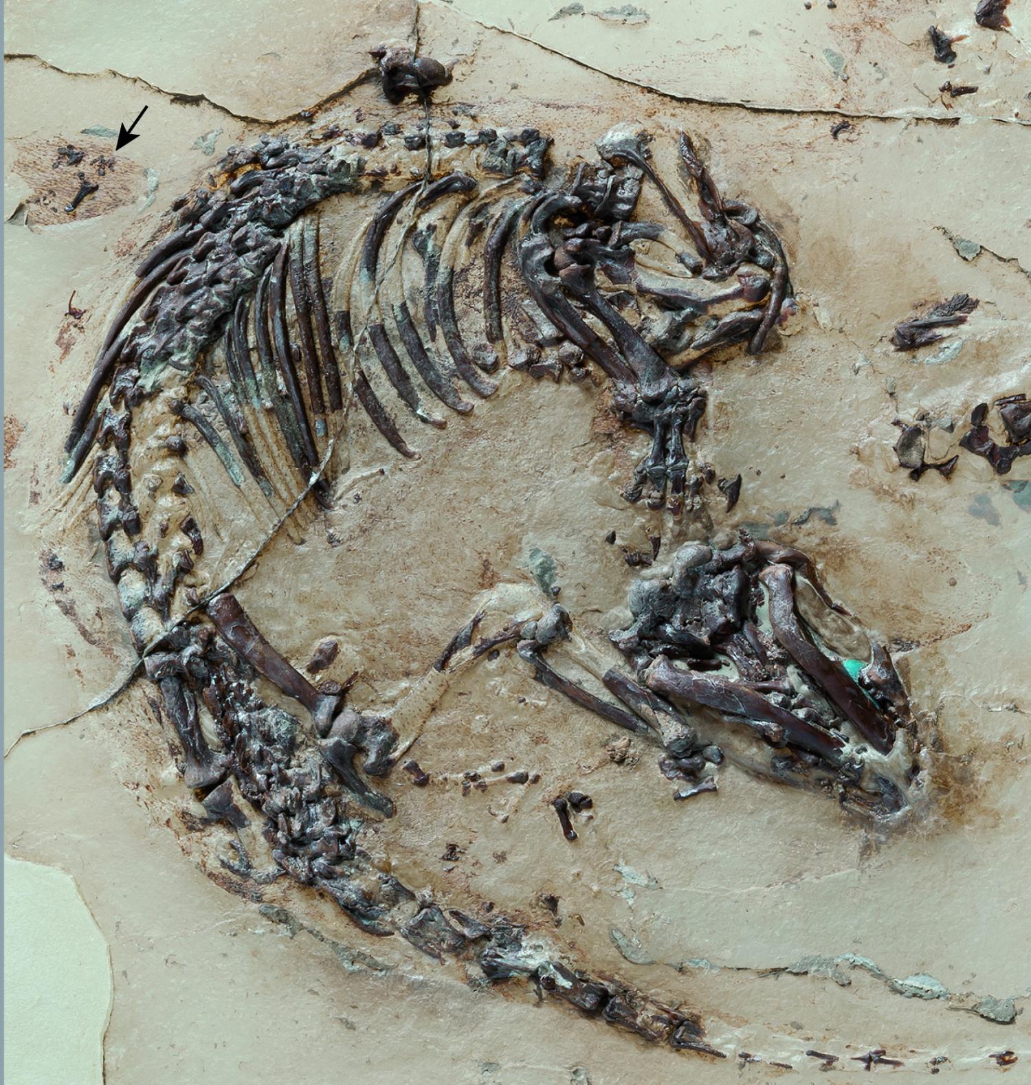
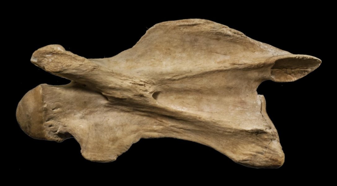
Skeleton of the Cretaceous mammal Spinolestes with preserved fur shadows. The outer ear can be seen at the upper edge of the photo (arrow). During preparation, the skeleton was transferred to a plastic matrix. Credit: Georg Oleschinski. With permission of Nature Publishing Group
The discovery of a new 125-million-year-old fossil mammal in Spain has pushed back the earliest record of preserved mammalian hair structures and inner organs by more than 60 million years.
The specimen, named Spinolestes xenarthrosus, was fossilized with remarkably intact guard hairs, underfur, tiny hedgehog-like spines and even evidence of a fungal hair infection. The unusually well-preserved fossil also contains an external ear lobe, soft tissues of the liver, lung and diaphragm, and plate-like structures made of keratin known as dermal scutes. The microscopic structures of hair and spines in Spinolestes are the earliest-known examples in mammalian evolutionary history.
The findings are described by scientists from the Autonomous University of Madrid, University of Bonn and the University of Chicago in a study published in Nature on Oct. 15.
“Spinolestes is a spectacular find. It is stunning to see almost perfectly preserved skin and hair structures fossilized in microscopic detail in such an old fossil,” said study co-author Zhe-Xi Luo, PhD, professor of organismal biology and anatomy at the University of Chicago. “This Cretaceous furball displays the entire structural diversity of modern mammalian skin and hairs.”
The Las Hoyas Quarry in east-central Spain was once a lush wetland with a thriving diversity of life around 125 million years ago during the early Cretaceous period. Spanish paleontologists have studied the site since 1985 and found hundreds of fossils, including important birds and dinosaurs. In 2011, the first mammal fossil at the site was discovered by a team led by Angela D. Buscalioni, PhD, professor of paleontology at the Autonomous University of Madrid, who partnered with collaborators including Luo and Thomas Martin, PhD, professor of paleontology at the University of Bonn, to study the rare specimen.
Cretaceous furball
Spinolestes xenarthrosus lived in the Cretaceous period and belonged to an extinct lineage of early mammals known as triconodonts. The specimen measured roughly 24 cm in length and is estimated to have weighed around 50 to 70 grams, about the size of a modern-day juvenile rat. Its teeth and skeletal features indicate it was a ground-dweller that ate insects. Its soft tissues, with discernable microscopic structures, were preserved through a rare process known as phosphatic fossilization. Individual hair follicles and bulbs, as well as the composition of individual hair shafts, could be identified using an electron scanning microscope.
Spinolestes had remarkably modern mammalian hair and skin structures, such as compound follicles in which multiple hairs emerge from the same pore. It had small spines around a tenth of a millimeter in diameter on its back, similar to modern hedgehogs and African spiny mice, which appeared to be formed by the fusion of filaments at follicles during development. The team even found abnormally truncated hairs that are evidence of a fungal skin infection known as dermatophytosis, which is widely seen among living mammals.
“Hairs and hair-related integumentary structures are fundamental to the livelihood of mammals, and this fossil shows that an ancestral, long-extinct lineage had grown these structures in exactly the same way that modern mammals do,” Luo said. “Spinolestes gives us a spectacular revelation about this central aspect of mammalian biology.”
Spinolestes is also the first example of a Mesozoic mammal in which soft tissues in the thoracic and abdominal cavities are fossilized. The team noted microscopic bronchiole structures of the lung, as well as iron-rich residues associated with the liver. These areas were separated by a curved boundary that is thought to be a muscular diaphragm for respiration. This represents the earliest-known record of mammalian organ systems.
The fossil of Spinolestes contains a large external ear, the earliest-known example in the mammalian fossil record, as well as dermal scutes — plate-like structures made of skin keratin. A more developed form of scutes can be seen in modern armadillos and pangolins.
Spinolestes had extra articulations between vertebrae, which strengthened its spinal column — modern-day mammals such as armored shrews and armadillos possess similar articulations. The authors speculate that this might provide a clue as to the lifestyle of Spinolestes. Armored shrews, for example, use their exceptional vertebral strength to push apart logs or dead palm leaves to feed on insects within.
“With the complex structural features and variation identified in this fossil, we now have conclusive evidence that many fundamental mammalian characteristics were already well-established some 125 million years, in the age of dinosaurs,” Luo said.
Reference:
Thomas Martin, Jesús Marugán-Lobón, Romain Vullo, Hugo Martín-Abad, Zhe-Xi Luo, Angela D. Buscalioni. A Cretaceous eutriconodont and integument evolution in early mammals. Nature, 2015; 526 (7573): 380 DOI: 10.1038/nature14905
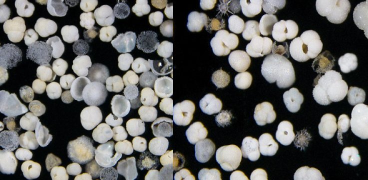
Left: Marine sediment core sample from the South Atlantic with fossilised partially dissolved shells of planktonic organisms. Right: Well-preserved plankton shells. Credit: Julia Gottschalk
A new study of the relationship between ocean currents and climate change has found that they are tightly linked, and that changes in the polar regions can affect the ocean and climate on the opposite side of the world within one to two hundred years, far quicker than previously thought.
The study, by an international team of scientists led by the University of Cambridge, examined how changes in ocean currents in the Atlantic Ocean were related to climate conditions in the northern hemisphere during the last ice age, by examining data from ice cores and fossilised plankton shells. It found that variations in ocean currents and abrupt climate events in the North Atlantic region were tightly linked in the past, and that changes in the polar regions affected the ocean circulation and climate on the opposite side of the world.
The researchers determined that as large amounts of fresh water were emptied into the North Atlantic as icebergs broke off the North American and Eurasian ice sheets, the deep and shallow currents in the North Atlantic rapidly slowed down, which led to the formation of sea ice around Greenland and the subsequent cooling of the Northern Hemisphere. It also strongly affected conditions in the South Atlantic within a matter of one to two hundred years. The results, published in the journal Nature Geoscience, show how climate events in the Northern Hemisphere were tightly coupled with changes in the strength of deep ocean currents in the Atlantic Ocean, and how that may have affected conditions across the globe.
During the last ice age, which took place from 70,000 to 19,000 years ago, the climate in the Northern Hemisphere toggled back and forth between warm and cold states roughly every 1000 to 6000 years. These events, known as Dansgaard-Oeschger events, were first identified in data from Greenland ice cores in the early 1990s, and had far-reaching impacts on the global climate.
The ocean, which covers 70% of the planet, is a huge reservoir of carbon dioxide and heat. It stores about 60 times more carbon than the atmosphere, and can release or take up carbon on both short and long timescales. As changes happen in the polar regions, they are carried around the world by ocean currents, both at the surface and in the deep ocean. These currents are driven by winds, ocean temperature and salinity differences, and are efficient at distributing heat and carbon around the globe. Ocean currents therefore have a strong influence on whether regions of the world are warm (such as Europe) or whether they are not (such as Antarctica) as they modulate the effects of solar radiation. They also influence whether CO2 is stored in the ocean or the atmosphere, which is very important for global climate variability.
“Other studies have shown that the overturning circulation in the Atlantic has faced a slowdown during the last few decades,” said Dr Julia Gottschalk of Cambridge Department of Earth Sciences, the paper’s lead author. “The scientific community is only beginning to understand what it would mean for global climate should this trend continue, as predicted by some climate models.”
Analysing new data from marine sediment cores taken from the deep South Atlantic, between the southern tip of South America and the southern tip of Africa, the researchers discovered that during the last ice age, deep ocean currents in the South Atlantic varied essentially in unison with Greenland ice-core temperatures. “This implies that a very rapid transmission process must have operated, that linked rapid climate change around Greenland with the otherwise sluggish deep Atlantic Ocean circulation,” said Gottschalk. Best estimates of the delay between these two records suggest that the transmission happened within about 100 to 200 years.
Digging through metres of ocean mud from depths of 3,800 metres, the team studied the dissolution of fossil plankton shells that was closely linked to the chemical signature of different water masses. Water masses originating in the North Atlantic are less corrosive than water masses from the South Atlantic.
“Periods of very intense North Atlantic circulation and higher Northern Hemisphere temperatures increased the preservation of microfossils in the sediment cores, whereas those with slower circulation, when the study site was primarily influenced from the south, were linked with decreased carbonate ion concentrations at our core site which led to partial dissolution,” said co-author Dr Luke Skinner, also from Cambridge’s Department of Earth Sciences.
To better understand the physical mechanisms of rapid ocean adjustment, the data was compared with a climate model simulation which covers the same period. “The data of the model simulation was so close to the deep ocean sediment data, that we knew immediately, we were on the right track,” said co-author Dr Laurie Menviel from the University of New South Wales, Australia, who conducted the model simulation.
The timescales of these large-scale adjustments found in the palaeoceanographic data agree extremely well with those predicted by the model. “Waves between layers of different density in the deep ocean are responsible for quickly transmitting signals from North to South. This is a paradigm shift in our understanding of how the ocean works,” said Axel Timmermann, Professor of Oceanography at the University of Hawaii.
Although conditions at the end of the last ice age were very different to those of today, the findings could shed light on how changing conditions in the polar regions may affect ocean currents. However, much more research is needed in this area. The study’s findings could help test and improve climate models that are run for both past and future conditions.
The sediment cores were recovered by Dr Claire Waelbroeck and colleagues aboard the French research vessel Marion Dufresne.
The research was supported by the Gates Cambridge Trust, the Natural Environmental Research Council of the UK, the Royal Society, the European Research Council, the Australian Research Council and the National Science Foundation of the United States of America.
Reference:
Julia Gottschalk, Luke C. Skinner, Sambuddha Misra, Claire Waelbroeck, Laurie Menviel, Axel Timmermann. Abrupt changes in the southern extent of North Atlantic Deep Water during Dansgaard–Oeschger events. Nature Geoscience, 2015; DOI: 10.1038/ngeo2558
Note: The above post is reprinted from materials provided by University of Cambridge. The original story is licensed under a Creative Commons Licence.
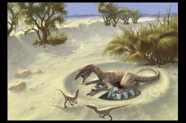
This is an artist’s rendering of oviraptorid theropods. Credit: Doyle Trankina and Gerald Grellet-Tinner
Were dinosaurs really fast, aggressive hunters like the ones depicted in the movie “Jurassic World”? Or did they have lower metabolic rates that made them move more like today’s alligators and crocodiles? For 150 years, scientists have debated the nature of dinosaurs’ body temperatures and how those temperatures influenced their activity levels.
New research by UCLA scientists indicates that some dinosaurs, at least, had the capacity to elevate their body temperature using heat sources in the environment, such as the sun. They also believe the animals were probably more active than modern-day alligators and crocodiles, which can be active and energetic, but only for brief spurts.
The researchers also found evidence that other dinosaurs they studied had lower body temperatures than modern birds, their only living relatives, and were probably less active.
The research is published in the journal Nature Communications.
Led by Robert Eagle, a researcher in the department of earth, planetary and space sciences in the UCLA College, the scientists examined fossilized dinosaur eggshells from Argentina and Mongolia. Analyzing the shells’ chemistry allowed them to determine the temperature at which the eggshells formed — information that had not been previously known.
“This technique tells you about the internal body temperature of the female dinosaur when she was ovulating,” said Aradhna Tripati, a co-author of the study and a UCLA assistant professor of geology, geochemistry and geobiology. “This presents the first the direct measurements of theropod body temperatures.”
The Argentine eggshells, which are approximately 80 million years old, are from large, long-necked titanosaur sauropods, members of a family that include the largest animals to ever roam Earth. The shells from Mongolia’s Gobi desert, 71 million to 75 million years old, are from oviraptorid theropods, much smaller dinosaurs that were closely related to Tyrannosaurus rex and birds.
Sauropods’ body temperatures were warm — approximately 100 degrees Fahrenheit, according to the study. The smaller dinosaurs had substantially lower temperatures, probably below 90 degrees.
Warm-blooded animals, or endotherms, produce heat internally and typically maintain their body temperature, regardless of the temperature of their environment; they do so mainly through metabolism. Humans and other mammals fall into this category.
Cold-blooded animals, or ectotherms, including alligators, crocodiles and lizards, rely on external environmental heat sources to regulate their body temperature. Lizards, for example, often sit on rocks in the sun to absorb heat, which enables them to be more active.
Scientists have debated since the 19th century whether dinosaurs were endotherms or ectotherms. The UCLA research indicates that the answer could lie somewhere in between. The dinosaurs, at least the oviraptorid theropods, had the ability to elevate their body temperature above the environmental temperature.
“The temperatures we measured suggest that at least some dinosaurs were not fully endotherms like modern birds,” Eagle said. “They may have been intermediate — somewhere between modern alligators and crocodiles and modern birds; certainly that’s the implication for the oviraptorid theropods.”
“This could mean that they produced some heat internally and elevated their body temperatures above that of the environment but didn’t maintain as high temperatures or as controlled temperatures as modern birds,” he added. “If dinosaurs were at least endothermic to a degree, they had more capacity to run around searching for food than an alligator would.”
The study was the first direct measurement of body temperatures in two types of dinosaurs. Tripati said it shows clearly that they are different from each other.
The researchers also analyzed fossil soils, including minerals that formed in the upper layer of the soil on which the oviraptorid theropods’ nests were built. This enabled them to estimate that the environmental temperature in Mongolia shortly before the dinosaurs went extinct was approximately 79 degrees Fahrenheit.
“The oviraptorid dinosaur body temperatures were higher than the environmental temperatures — suggesting they were not truly cold-blooded, but intermediate,” Tripati said.
Eagle, Tripati and their colleagues initially measured modern eggshells from 13 bird species and nine reptiles to establish their ability to measure body temperature from the chemistry of eggshells.
The researchers measured, in calcium carbonate minerals, the subtle differences in the abundance of chemical bonding between two rare, heavy isotopes: carbon-13 and oxygen-18. They studied the extent to which these heavy isotopes clustered together using a mass spectrometer — a technique that enabled them to determine mineral formation temperatures. Mineral forming inside colder bodies has more clustering of isotopes.
The scientists analyzed six fossilized eggshells from Argentina, three of which were well-preserved, and 13 eggshells from Mongolia’s Gobi desert, again selecting three that are well-preserved. They determined whether the fossilized eggshells maintain their original chemistry or were altered over tens of millions of years. They also analyzed fossilized dinosaur eggshells from France, but found these were not well-preserved, and excluded them.
The researchers acquired the Argentine eggshells from the Los Angeles County Natural History Museum, and the eggshells from Mongolia’s Gobi desert from New York’s American Natural History Museum.
Eagle, Tripati and colleagues published the first analysis of fossilized dinosaur teeth in the journal Science in 2011. They studied the chemistry of fossil teeth to measure the body temperature of titanosaur sauropods, and determined their body temperature was between approximately 95 and 100.5 degrees Fahrenheit. The new research on eggshells is consistent with the 2011 findings, and adds new body temperature data on oviraptorid theropods.
Reference:
Robert A. Eagle, Marcus Enriquez, Gerald Grellet-Tinner, Alberto Pérez-Huerta, David Hu, Thomas Tütken, Shaena Montanari, Sean J. Loyd, Pedro Ramirez, Aradhna K. Tripati, Matthew J. Kohn, Thure E. Cerling, Luis M. Chiappe, John M. Eiler. Isotopic ordering in eggshells reflects body temperatures and suggests differing thermophysiology in two Cretaceous dinosaurs. Nature Communications, 2015; 6: 8296 DOI: 10.1038/ncomms9296
Note: The above post is reprinted from materials provided by University of California – Los Angeles. The original item was written by Stuart Wolpert.
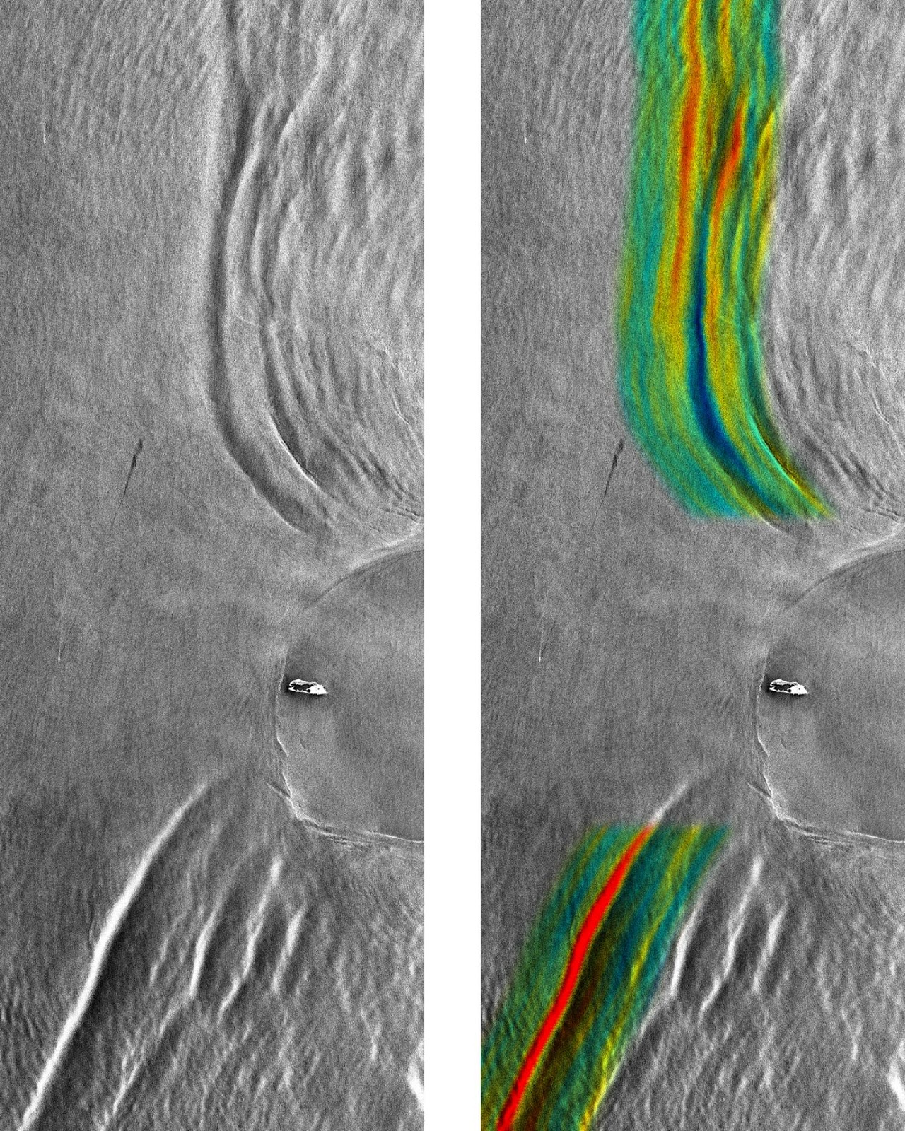
These two figures show the internal waves at Dongsha Island on April 23, 2010, as seen by the radar on TerraSAR-X in its conventional mode of operation (left) and in the experimental new mode that permits direct velocity measurements (right), with the measured surface velocities shown in color. Red and blue colors indicate surface velocities of about 0.5 m/s to the left and to the right, respectively. The shown area is 30 km × 80 km. Dongsha Island, which is about 2.7 km × 0.9 km (1.7 mi × 0.6 mi) in size, can be seen near the center of the image. Credit: German Aerospace Center (DLR) 2010.
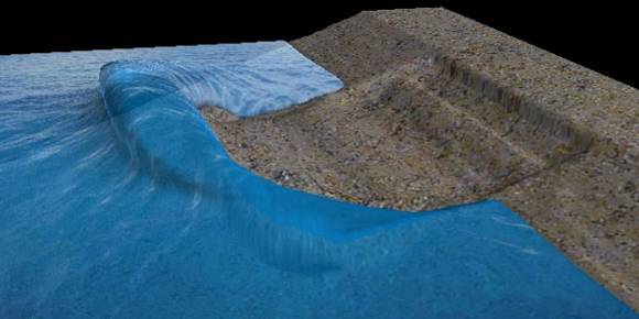
For the first time researchers directly measured the speed of a wave located 80 meters below the ocean’s surface from a single satellite image. The new technique developed by researchers from the University of Miami (UM) Rosenstiel School of Marine and Atmospheric Science is a major advancement in the study of these skyscraper-high internal waves that rarely break the ocean surface.
“This is the first time internal wave velocities could be calculated from data acquired during a single overpass of a satellite,” said Roland Romeiser, associate professor of ocean sciences at the UM Rosenstiel School. “This allows us to obtain more accurate information from a satellite that we could in the past.”
Using a single satellite image collected at UM’s Center for Southeastern Tropical Remote Sensing (CSTARS), the research team was able to determine that a roughly 60-meter high internal wave was traveling at a speed of three miles per hour (1.4 meters per second) near Dongsha Island in the South China Sea. The region is considered to have some of the most powerful internal waves on the planet.
“This is a significant breakthrough using a single image to determine the velocity of a wave below the surface,” said Hans Graber, UM Rosenstiel School professor of ocean sciences and director of CSTARS. “This technology offers new opportunities to track the speed of ocean currents or objects moving on or below the ocean surface.”
Radar satellites can detect the surface ripples produced by internal waves and the data collected allow researchers to calculate the speed of internal waves traveling below the surface. Prior to the development of this new technology, researchers would have to compare several images taken during multiple satellite overpasses to estimate internal wave velocities. The radar affixed to the German satellite TerraSAR-X is the first to measure velocities directly during a single overpass but with significant noise. Romeiser and Graber developed a new method to process the data that enhances the internal wave patterns to extract the velocities with unprecedented accuracy. CSTARS is the only place besides the German Aerospace Center (DLR) that is capable of processing these types of images.
Internal waves move huge volumes of heat, salt, and nutrient rich-water across the ocean, which is important to fish, industrial fishing operations and the global climate. In addition, they are important to monitor for safe surface and sub-surface marine operations.
Graber was part of an international research team that spent seven years tracking the movements of internal waves to understand how these waves develop, move and dissipate underwater. The team discovered that internal waves are generated daily from internal tides, which also occur below the ocean surface, and grow larger as the water is pushed westward through the Luzon Strait into the South China Sea. Their findings were published in the May 7 issue of the journal Nature.
A research team led by Romeiser was the first to accurately measure currents from a space shuttle platform between islands off the Dutch coast and the first to make current measurements using the radar on the TerraSAR-X satellite.
The study, titled “Advanced Remote Sensing of Internal Waves by Spaceborne Along-Track InSAR—A Demonstration With TerraSAR-X,” appears in the Dec. 2015 issue of the journal Transactions on Geoscience and Remote Sensing, a publication of the Institute of Electronic and Electrical Engineers (IEEE). The study’s authors are Roland Romeiser and Hans Graber of the UM Rosenstiel School. The work was supported by grants from the U.S. Office of Naval Research.
Reference:
The study, titled “Advanced Remote Sensing of Internal Waves by Spaceborne Along-Track InSAR—A Demonstration With TerraSAR-X,” appears in the Dec. 2015 issue of the journal Transactions on Geoscience and Remote Sensing, a publication of the Institute of Electronic and Electrical Engineers (IEEE). DOI: 10.1109/TGRS.2015.2447547.
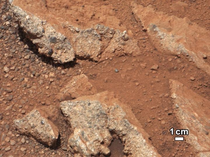
The presence of rounded pebbles on Mars was evidence of a prior history of water on the planet. In a new study, researchers have used the pebbles’ shape to extrapolate how far they must have traveled down an ancient riverbed. The analysis suggests they moved approximately 30 miles, indicating that Mars once had an extensive river system. Credit: NASA/JPL-Caltech/MSSS
While new evidence suggests that Mars may harbor a tiny amount of liquid water, it exists today as a largely cold and arid planet. Three billion years ago, however, the situation may have been much different.
In 2012 the Mars Curiosity rover beamed images back to Earth containing some of the most concrete evidence that water once flowed in abundance on the planet. Small, remarkably round and smooth pebbles suggested that an ancient riverbed had once carried these rocks and abraded them as they traveled.
To Douglas Jerolmack, a geophysicist at the University of Pennsylvania, and his collaborator Gábor Domokos, a mathematician at Budapest University of Technology and Economics, Curiosity’s findings raised a fundamental geological question: Can we use shape alone to interpret the transport history of river pebbles — on Mars, Earth or any planet?
“Thousands of years ago, Aristotle pondered the question of pebbles on the beach and how they become rounded,” Jerolmack said. “But until recently, descriptions of pebble shape have been qualitative, and we lacked a basic understanding of the rounding process.”
Now that has changed. In a new report in Nature Communications, Jerolmack, Domokos and colleagues report the first-ever method to quantitatively estimate the transport distance of river pebbles from their shape alone. The researchers’ estimate that the Martian pebbles traveled roughly 30 miles from their source, providing additional evidence for the idea that Mars once had an extensive river system, conditions that could support life.
Determining how far pebbles have traveled could also be useful for studies on Earth, for example in identifying sources of river-transported resources, such as gold.
Jerolmack, an associate professor in the Department of Earth and Environmental Science in Penn’s School of Arts & Sciences and senior author on the paper, contributed expertise in geophysics to the study, while co-author Domokos developed the mathematical models on which the study was based. Tímea Szabó, the lead author, worked with Domokos as a graduate student and was then a postdoctoral researcher in Jerolmack’s lab. John P. Grotzinger, at the California Institute of Technology, was until recently the lead scientist for NASA’s Curiosity mission and collaborated on the work.
The development of a quantitative understanding of pebble shapes began with the work of Domokos, whose research was triggered by the discovery of the Gömböc, a curious three-dimensional object with just two static balance points. A Gömböc shape self-rights on a horizontal surface just like a Weeble Wobble, however, it has no added bottom weight. The self-righting property is the result of the shape alone, which is determined to 0.01 percent accuracy by its unique mechanical properties.
As the number of static balance points on an object tends to be reduced during natural abrasion, the Gömböc represents the ultimate goal of this process and illustrates how shape alone may carry vital information on natural history. Domokos soon realized that recent pioneering work in pure mathematics — the proof of the elusive Poincaré conjecture — could be adapted to describe the geometry of three-dimensional structures and how these shapes evolve.
“An object’s shape can itself tell you a lot,” said Domokos. “If you go to the beach, natural history is written underneath your feet. We started to understand that there is a code that you can read to begin to understand that history.”
Rocks flowing in rivers evolve in shape from being abraded against other rocks in the riverbed, gradually losing mass and taking on a smoother, rounder shape. Existing geophysical theory links a pebble’s transport history to the mass it loses due to collisions with other pebbles. But mass data is not available for Martian pebbles. So the researchers set the ambitious goal of determining the lost mass of a pebble solely based on its current shape.
“When you land a multi-billion dollar rover on Mars, you want to extra as much information from the data as possible,” Jerolmack said.
Domokos’ work showed that, when two particles of similar size bang together, the way in which they influence each other’s shape can be reduced to a purely geometric problem, regardless of the rock’s material or the environment in which it is moving.
The research team went to the lab to test this theory, rolling limestone fragments in a drum and periodically pausing to record their shape changes and mass loss. The pattern of the rocks’ shape change closely followed the curve established by the mathematical theory.
Next the researchers went to a mountain river in Puerto Rico.
“We started at the headwaters, where chunks of angular rock are breaking off from the walls of the stream, and went downstream,” Jerolmack said. “Every few hundred meters we would pull thousands of rocks out and take images of their silhouette and record their weight.”
Plotting the data, they again found a trend between shape evolution and mass loss that agreed with the geometric model Domokos had developed.
As an additional confirmation, they performed a similar analysis on rocks in an alluvial fan, the characteristic fan-shaped sediment deposits built up by stream flows, at the mouth of a canyon in New Mexico, an environment that more closely mirrors the location where round pebbles were found on Mars. With these data, they demonstrated that they can infer the distance a pebble traveled from its source using only the silhouette of the pebble.
With lab and field data in hand, they turned to the extraterrestrial. Using publicly available images of rounded pebbles on Mars from the Curiosity rover mission, Szabó traced their contours and performed an analysis based on the models the team had established. The results suggested that the pebbles had lost approximately 20 percent of their volume.
To translate that mass loss into a distance traveled, they relied on the findings from New Mexico as well as previous lab experiments that involved running rocks of different material through artificial “rivers” and measuring their mass loss.
Applying these calculations to the basalt material found on Mars, with a correction that factored in the reduced Martian gravity, they arrived at the calculation that the pebbles had traveled an estimated 50 kilometers, or about 30 miles from their source. The distance meshed well with what Grotzinger and the Curiosity team had suspected about the pebbles’ origin, based on other analyses of the rock’s composition and clues as to the direction of water flow, that they were sourced from a crater rim located approximately 30 kilometers away.
Jerolmack noted that the study is not only exciting for what it implies about Mars but for opening up a new realm of possibility to quantify what before could only be described qualitatively.
“Now we have a new tool we can use to help reconstruct ancient environments on Earth, Mars and other planetary bodies where rivers are found such as Titan,” Jerolmack said.
The work also shows how a seemingly esoteric piece of mathematics can find application in the real world.
“Once math enters the subject, the subject changes forever,” Domokos said.
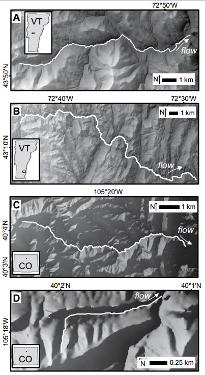
Stream locations (white lines) and topography (shaded relief from 10 m DEM, US Geological Survey [USGS] National Map). A: West Branch of White River, Vermont, USA, watershed area 112 km2, channel relief 632 to 232 m asl (above sea level). B: Saxtons River, Vermont, USA, watershed area 180 km2, channel relief 550 to 120 m asl. C: Fourmile Canyon Creek, Colorado, USA, watershed area 19 km2, channel relief 2419 to 1687 m asl. D: Mount Sanitas, Colorado, USA, watershed area 0.7 km2, channel relief 1953 to 1694 m asl. Credit: Gartner et al. and Geology Catastrophic floods in 2011 in Vermont and 2013 in Colorado devastated many communities. While flood waters were the highest in recorded history, much of the damage done by these floods was not related to inundation by flood water, but instead caused by abundant erosion and sedimentation. These floods provided a rare opportunity to better understand controls on the locations of these different hazards.
In their study for Geology, John D. Gartner and colleagues explore the effects of downstream increases and decreases in stream power, which are linked in part to variations in river slope constrained by underlying geology. A physics-based relationship indicates that river reaches are susceptible to erosion, such as landslides and bank failures, where stream power increases in the downstream direction. Conversely, river reaches are prone to floodplain sedimentation where stream power decreases in the downstream direction, because the river cannot carry the load delivered from upstream.
These predictions are compared with observed locations of erosion and sedimentation along four rivers severely affected by these floods. Gartner and colleagues’ analysis successfully predicts river channel and floodplain responses in almost 90% of cases studied. This direct field evidence highlights the potential role of downstream changes in stream power in connections between river channels and laterally-adjacent banks, slopes, and floodplains.
Reference:
Gradients in stream power influence lateral and down-stream sediment flux in floods
John D. Gartner et al., Department of Earth Science, Dartmouth College, Hanover, New Hampshire 03755, USA. This paper is online at DOI: 10.1130/G36969.1
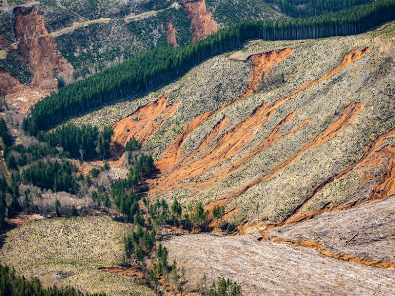
Landslides from recently logged steep slopes dumped millions of tons of mud and debris into Stillman Creek, near Curtis, Wash., in December 2007. Landslides like these may be easier to predict thanks to a new search algorithm derived from quantitative slope stability models. Credit: David Perry
Because landslides can destroy property and reshape landscapes, scientists seek to predict when they will strike and to model their behavior. Previous work revealed that location and size are the most important characteristics that determine the impacts of shallow landslides less than a few meters deep. However, modeling these parameters presents unique challenges to researchers.
One common strategy involves digitally representing the landscape as a grid of adjacent cells or blocks with different physical properties, such as elevation, slope, soil depth, and pore pressure. This approach allows researchers to simulate the landscape in three dimensions, incorporate variation between cells, and account for the lateral effects of friction and plant root reinforcement.
However, the spatial arrangement of groups of unstable grid cells is not known. To overcome this issue, the computer could try to test every possible arrangement of blocks, but this strategy becomes computationally demanding or even impossible as the number of blocks increases. The authors point out that testing a 1-square-kilometer area composed of 1 million blocks generates 21,000,000 possible arrangements—a computational task beyond even our best computers.
To help reduce this burden, Bellugi et al. developed a search algorithm—a sequence of computer operations—that analyzes hillslope properties and outputs clusters of unstable blocks, allowing larger swaths of land to be analyzed using the gridded cell method. The team tested their new model on a virtual hillside as well as on data obtained from a landslide in Coos Bay, Ore. The algorithm performed well in both cases, allowing scientists to predict the location and approximate size of landslides with useful accuracy.
The results should allow future teams to better understand how shallow landslides develop in three dimensions without the need for such arduous computation. They should also give scientists the ability to scout for hazardous conditions that might cause loss of human life or property.
Reference:
hultz, D. (2015), Efficiently predicting shallow landslide size and location, Eos, 96, DOI:10.1029/2015EO037063. Published on 8 October 2015.
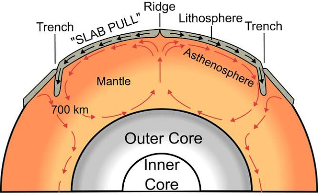
Mantle convection – the process that drives plate tectonics. Credit: Surachit/wikimedia, CC BY-SA
According to recent estimates, the Earth’s solid inner core started forming between half a billion and one billion years ago. However, our new measurements of ancient rocks as they cool from magma have indicated that it may actually have started forming more than half a billion years earlier.
While this is still relatively late in the Earth’s four-and-a-half billion year history, the implication is that the Earth’s deep interior may not have been as hot in the deep past as some have argued. That means the core is transferring heat to the surface more slowly than previously thought, and is less likely to play a big role in shaping the Earth’s surface through tectonic movements and volcanoes.
Just after the Earth formed from collisions in a huge cloud of material that also formed the Sun, it was molten. This was because of the heat generated by the formation process and the fact that it constantly collided with other bodies. But after a while, as the bombardment slowed, the outer layer cooled to form a solid crust.
The Earth’s inner core is, today, a Pluto-sized ball of solid iron at the centre of our planet surrounded by an outer core of molten iron alloyed to some, as yet unknown, lighter element. Despite the Earth being hottest at its centre (about 6,000°C), liquid iron freezes into a solid because of the very high pressures there. As the Earth continues to cool down, the inner core grows at a rate of about 1mm per year by this freezing process.
Knowing the point in time at which the Earth’s centre cooled down sufficiently to first freeze iron gives us a fundamental reference point for the entire thermal history of the planet.
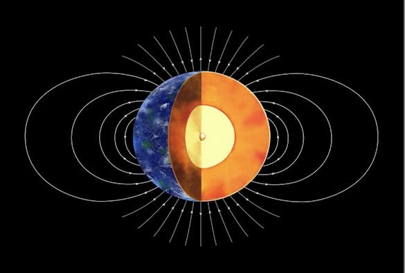
The magnetic field of the Earth is generated by the movement of electrically conducting molten iron in the outer core. This movement is generated by light elements released at the inner core boundary as it grows. Therefore, the time when iron was first frozen also represents a point in time when the outer core received a strong additional source of power.
It is the signature of this boost of the magnetic field – the largest long-term increase in its entire history – that we think we have observed in the magnetic records recovered from igneous rocks formed at this time. Magnetic particles in these rocks “lock-in” the properties of the Earth’s magnetic field at the time and place that they cool down from magma.
The signal can then be recovered in the laboratory by measuring how the magnetisation of the rock changes as it progressively heated up in a controlled magnetic field. Hunting for this signature is not a new idea but has only just become viable – a combination of having increased amounts of measurement data available and new approaches to analysing them.
The Earth has maintained a magnetic field for most of its history through a “dynamo” process. This is similar in principle to a wind-up radio or a bicycle-powered light bulb in that mechanical energy is converted to electromagnetic energy. Before the inner core first started to solidify, this “geodynamo” is thought to have been powered by another entirely different and inefficient “thermal convection” process.
Once iron started to freeze out of the liquid at the base of the core, the remainder became less dense, providing an additional source of buoyancy and leading to much more efficient “compositional convection”. Our results suggest that this efficiency saving happened earlier in the Earth’s history than previously thought, meaning that the magnetic field would have been sustained for longer with less energy overall. Since the energy is mostly thermal, this implies that the core as a whole is likely cooler than it would have been if the inner part formed later.
Heat and plate tectonics
A cooler core implies lower heat flow across the core-mantle boundary. This is important for all of Earth sciences because it could be one of the drivers for making tectonic plates move and is also a source of plume volcanism at the Earth’s surface. We know that these processes are a result of mantle convection produced, ultimately, by the flow of heat out of the planet at a rate that we can measure rather precisely. What we still do not know is how much of this heat lost at the Earth’s surface is from the mantle and how much is from the core.
Heating from the core is thought to produce plumes welling up from just above the core-mantle boundary, which might help drive the flow within the mantle. The suggestion from our findings is that the core contribution to the surface heat flow is lower than implied from other studies and that subduction in the ocean, when one tectonic plate goes under another down into the mantle, are much more important in driving mantle convention than the heat rising from the core.
The debate about the age of the inner core and the resulting thermal evolution of the Earth is not yet over. More palaeomagnetic data are needed to confirm that the sharp increase in magnetic field strength that we have observed is really the largest in the planet’s history. Furthermore, modelling needs to verify whether some other event could have created the magnetic strengthening at this time.
Nevertheless, as things stand, theory and observation combine to indicate that the Earth was two-thirds of its present age before it started growing an inner core – meaning earth scientists may have to revise their understanding of the planet’s history.
Note: The above post is reprinted from materials provided by The Conversation. This story is published courtesy of The Conversation (under Creative Commons-Attribution/No derivatives).The Conversation
Three-dimensional numerical simulation of a tsunamigenic landslide event. Credit: Museum fuer Naturkunde, Berlin
Australia’s coastline may be vulnerable to rare landslides with potentially disastrous consequences, according to ongoing research by the University of Sydney.
Undertaken by the University’s School of Geosciences, the research is detailed in a chapter in Southern Surveyor: Stories from on board Australia’s ocean research vessel, a new book from CSIRO Publishing.
It’s hard to understand how these slopes ever fail yet the evidence is they can, because there are enormous scars, or scoops, along the continental margin from Bateman’s Bay to Fraser Island,” said Associate Professor Tom Hubble, lead researcher on the project.
“One of the largest examples of these continental scars is located off Bulli in New South Wales, and is 16 kilometres long, nine kilometres wide and roughly 300 to 400 metres thick.”
Importantly, the landslide events and the earthquakes that could trigger them are considered to be extremely rare, according to Associate Professor Hubble and his team.
“You might get one landslide every 10,000 years that could generate a wave of more than five metres in height. A wave height of more than 20 metres would only occur every 100,000 or even every million years.
“The big questions for us are how many, how big and how often? And we’re making some progress on this.
“We have actually identified 400 landslides that have occurred over the last 4 million years that are big enough to have generated a tsunami, most of which would have generated a tsunami with a one to two metre wave height.
“Around 50 to 100 of these could have generated something around five to 10 metres in wave height, which is the size of the tsunamis that came through Indonesia and Japan.
“We need to do more investigation to constrain these numbers reliably.”
Researchers believe the landslides could be triggered by large earthquakes, likely of magnitude six to seven, and are now investigating this theory.
“We are interested in conducting further studies in a section referred to as ‘the Block’ near Brisbane, which is about half a kilometre thick and 10 kilometres long, and has noticeable tension cracks.
“If an earthquake of the right magnitude occurred, we believe it could trigger a significant tsunami,” Associate Professor Hubble said.
Understanding these scoops and their potential sites, as well as their tsunami generating capabilities, has so far been restricted by the sonar technology on board the vessel Southern Surveyor, which could only map the sea floor to 3000 metres. The continental slope begins about 50 kilometres off the Australian coast and drops away to the abyssal plain, which is 4000 to 5000 metres deep.
Southern Surveyor: Stories from on board Australia’s ocean research vessel follows the adventures of the men and women on board the CSIRO Marine National Facility research vessel over the course of a year, as told by author Michael Veitch.
For 10 years, the Southern Surveyor represented the vanguard of Australian blue water marine science. On more than 100 voyages, this former North Sea fishing trawler with her distinctive blue and white livery carried scientists and technicians across the Southern, Pacific and Indian Oceans as well as the waters off northern Australia.
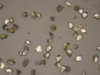
This is a photo of nano-diamonds using an optical microscope. The purpose is to characterize the size of nano-diamonds. Credit: Photo by Ewa Rej, the University of Sydney
Physicists from the University of Sydney have devised a way to use diamonds to identify cancerous tumours before they become life threatening.
Their findings, published in Nature Communications, reveal how a nanoscale, synthetic version of the precious gem can light up early-stage cancers in non-toxic, non-invasive Magnetic Resonance Imaging (MRI) scans.
Targeting cancers with tailored chemicals is not new but scientists struggle to detect where these chemicals go since, short of a biopsy, there are few ways to see if a treatment has been taken-up by a cancer.
Led by Professor David Reilly from the School of Physics, researchers from the University investigated how nanoscale diamonds could help identify cancers in their earliest stages.
“We knew nano diamonds were of interest for delivering drugs during chemotherapy because they are largely non-toxic and non-reactive,” says Professor Reilly.
“We thought we could build on these non-toxic properties realising that diamonds have magnetic characteristics enabling them to act as beacons in MRIs. We effectively turned a pharmaceutical problem into a physics problem.”
Professor Reilly’s team turned its attention to hyperpolarising nano-diamonds, a process of aligning atoms inside a diamond so they create a signal detectable by an MRI scanner.
“By attaching hyperpolarised diamonds to molecules targeting cancers the technique can allow tracking of the molecules’ movement in the body,” says Ewa Rej, the paper’s lead author.
“This is a great example of how quantum physics research tackles real-world problems, in this case opening the way for us to image and target cancers long before they become life-threatening,” says Professor Reilly.
The next stage of the team’s work involves working with medical researchers to test the new technology on animals. Also on the horizon is research using scorpion venom to target brain tumours with MRI scanning.
Reference:
Ewa Rej, Torsten Gaebel, Thomas Boele, David E.J. Waddington, David J. Reilly. Hyperpolarized nanodiamond with long spin-relaxation times. Nature Communications, 2015; 6: 8459 DOI: 10.1038/ncomms9459
Note: The above post is reprinted from materials provided by University of Sydney.
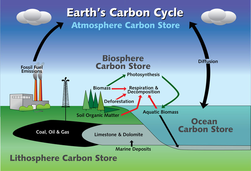
Earth’s Carbon Cycle Credit to NYS Department of Environmental Conservation
Making predictions about climate variability often means looking to the past to find trends. Now paleoclimate researchers from the University of Missouri have found clues in exposed bedrock alongside an Alabama highway that could help forecast climate variability. In their study, the researchers verified evidence suggesting carbon dioxide decreased significantly at the end of the Ordovician Period, 450 million years ago, preceding an ice age and eventual mass extinction. These results will help climatologists better predict future environmental changes.
The Ordovician geologic period included a climate characterized by high atmospheric carbon dioxide (CO2) levels, warm average temperatures and flourishing life. Near the end of the period, CO2 levels dropped significantly but precisely when and how fast is poorly known. Kenneth MacLeod, a professor in the Department of Geological Sciences in the MU College of Arts and Science, directed a research team studying the climate changes 450 million years ago to better understand the interactions among the biosphere, the oceans, atmospheric CO2 levels, and temperature.
“Climate is not a simple science; many small factors determine what exactly leads to global warming and cooling trends,” MacLeod said. “By understanding the deep past, we have better information about historic trends that lead to better predictions. Understanding carbon cycles adds value to our knowledge base of climate change.”
During the Late Ordovician period, most of North America was covered in a shallow tropical sea. What is now Alabama was on the margin of that sea where local environmental effects likely did significantly impact carbon cycling. Page Quinton, a doctoral student in MU’s geological sciences program, led a field research team in northeastern Alabama that collected rock samples from rock formations exposed when workers cut highways through hills in the region. Using the samples, Quinton analyzed them for chemical clues that can be related to CO2 levels at specific time periods.
“After examining rocks 450 million years old or older, we believe the drop was caused by a massive burial of organic carbon during the time period,” Quinton said. “We’re trying to determine whether or not there was an increase in plant productivity, or huge algae blooms in the ocean, that died and fell to the sea floor, basically burying CO2. This burial, coupled with the mountain building event that created the Appalachian Mountains, could have contributed to the resulting ice age.”
A drop in CO2 due to the burial of organic carbon in the Late Ordovician is the exact opposite of what is happening now as massive amounts of CO2 are being released; yet, understanding how the historic events occurred can help with future models and predictions, Macleod said.
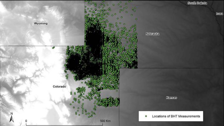
This is spatial extent of temperature data in the Denver-Julesberg basin, obtained from the National Geothermal Data System. Green points represent the locations of the 36,861 wells used for bottom-hole temperature and geothermal gradient calculations. Credit: Anna Crowell and Will Gosnold and Geosphere.
To offset the need for fuel imports, to decrease greenhouse gas emissions, and to increase U.S. energy independence, geothermal energy has emerged as an important part of the U.S. energy portfolio. This well-illustrated study, published in Geosphere this week, presents a new and inexpensive method using Geographic information system (GIS) and National Geothermal Data System data to evaluate a region for geothermal energy exploration.
Authors Anna Crowell and Will Gosnold gathered and analyzed free-access GIS data for trends that could help geoscientists assess whether a sedimentary basin could be economically utilized for geothermal power production. In their article, they identify several counties in the states of Colorado, Illinois, Michigan, and North Dakota where geothermal energy could be used for different energy production scenarios.
In particular, they find that the Denver-Julesberg Basin (which spans Wyoming, Nebraska, and Colorado, and has a surface area of approx. 155,000 square kilometers) has the highest capacity for large-scale, economically feasible geothermal power production. They write that, “assuming an adequate, sustainable water supply,” high-population areas west of Denver, near the depocenter of the basin and the Golden fault along the Front Range of the Rocky Mountains, are of greatest interest because costly infrastructure is already in place.
Reference:
Integrating geophysical data in GIS for geothermal power prospecting
Anna Crowell and Will Gosnold, University of North Dakota, Harold Hamm School of Geology and Geological Engineering, Grand Forks, North Dakota 58202, USA. This article is online at http://geosphere.gsapubs.org/content/early/2015/10/02/GES01161.1.abstract. Themed issue: Geothermal Energy from Sedimentary Basins: Challenges, Potential, and Ways Forward.
A view from the Kimberley formation looking south. The strata in the foreground dip towards the base of Mount Sharp, indicating the ancient depression that existed before the larger bulk of the mountain formed. Credit: NASA/JPL-Caltech.
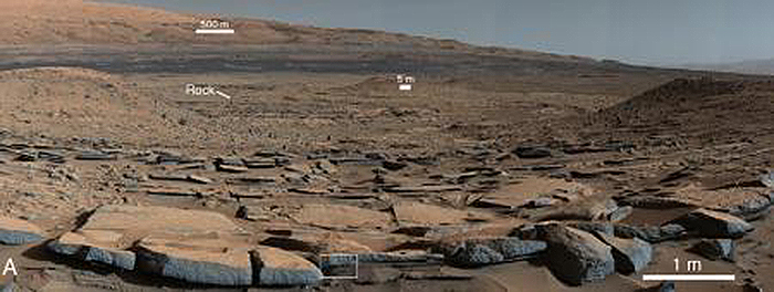
We have heard the Mars exploration mantra for more than a decade: follow the water. In a new paper published October 9, 2015, in the journal Science, the Mars Science Laboratory (MSL) team presents recent results of its quest to not just follow the water but to understand where it came from, and how long it lasted on the surface of Mars so long ago.
The story that has unfolded is a wet one: Mars appears to have had a more massive atmosphere billions of years ago than it does today, with an active hydrosphere capable of storing water in long-lived lakes. The MSL team has concluded that this water helped to fill Gale Crater, the MSL rover Curiosity’s landing site, with sediment deposited as layers that formed the foundation for the mountain found in the middle of the crater today.
Curiosity has been exploring Gale Crater, which is estimated to be between 3.8 billion and 3.6 billion years old, since August 2012. In mid-September 2014, the rover reached the foothills of Aeolis Mons, a three-mile-high layered mountain nicknamed “Mount Sharp” in honor of the late Caltech geologist Robert Sharp. Curiosity has been exploring the base of the mountain since then.
“Observations from the rover suggest that a series of long-lived streams and lakes existed at some point between 3.8 billion to 3.3 billion years ago, delivering sediment that slowly built up the lower layers of Mount Sharp,” says Ashwin Vasavada (PhD ’98), MSL project scientist. “However, this series of long-lived lakes is not predicted by existing models of the ancient climate of Mars, which struggle to get temperatures above freezing,” he says.
This mismatch between the predictions of Mars’s ancient climate that arise from models developed by paleoclimatologists and indications of the planet’s watery past, as interpreted by geologists, bears similarities to a century-old scientific conundrum–in this case, about Earth’s ancient past.
At the time, geologists first began to recognize that the shapes of the continents matched each other, almost like scattered puzzle pieces, explains John Grotzinger, Caltech’s Fletcher Jones Professor of Geology, chair of the Division of Planetary and Geological Sciences, and lead author of the paper. “Aside from the shapes of the continents, geologists had paleontological evidence that fossil plants and animals in Africa and South America were closely related, as well as unique volcanic rocks suggestive of a common spatial origin. The problem was that the broad community of earth scientists could not come up with a physical mechanism to explain how the continents could plow their way through Earth’s mantle and drift apart. It seemed impossible. The missing component was plate tectonics,” he says. “In a possibly similar way, we are missing something important about Mars.”
As Curiosity has trekked across Gale Crater, it has stopped to examine numerous areas of interest. All targets are imaged, and soil samples have been scooped from some; the rocks in a select few places have been drilled for samples. These samples are deposited into the rover’s onboard laboratories. Using data from these instruments, as well as visual imaging from the onboard cameras and spectroscopic analyses, MSL scientists have pieced together an increasingly coherent and compelling story about the evolution of this region of Mars.
Before Curiosity landed on Mars, scientists proposed that Gale Crater had filled with layers of sediments. Some hypotheses were “dry,” implying that the sediments accumulated from wind-blown dust and sand, whereas others focused on the possibility that sediment layers were deposited in ancient streams and lakes. The latest results from Curiosity indicate that these wetter scenarios were correct for the lower portions of Mount Sharp. Based on the new analysis, the filling of at least the bottom layers of the mountain occurred mostly by ancient rivers and lakes.
“During the traverse of Gale, we have noticed patterns in the geology where we saw evidence of ancient fast-moving streams with coarser gravel as well as places where streams appear to have emptied out into bodies of standing water,” Vasavada says. “The prediction was that we should start seeing water-deposited, fine-grained rocks closer to Mount Sharp. Now that we’ve arrived, we’re seeing finely laminated mudstones in abundance.” These silty layers in the strata are interpreted as ancient lake deposits.
“These finely laminated mudstones are very similar to those we see on Earth,” says Woody Fischer, professor of geobiology at Caltech and coauthor of the paper. “The scale of lamination–which occurs both at millimeter and centimeter scale–represents the settling of plumes of fine sediment through a standing body of water. This is exactly what we see in rocks that represent ancient lakes on Earth. “The mudstone indicates the presence of bodies of standing water in the form of lakes that remained for long periods of time, possibly repeatedly expanding and contracting during hundreds to millions of years. These lakes deposited the sediment that eventually formed the lower portion of the mountain.
“Paradoxically, where there is a mountain today there was once a basin, and it was sometimes filled with water,” says Grotzinger. “Curiosity has measured about 75 meters of sedimentary fill, but based on mapping data from NASA’s Mars Reconnaissance Orbiter and images from Curiosity’s cameras, it appears that the water-transported sedimentary deposition could have extended at least 150-200 meters above the crater floor, and this equates to a duration of millions of years in which lakes could have been intermittently present within the Gale Crater basin” Grotzinger says. Furthermore, the total thickness of sedimentary deposits in Gale Crater that indicate interaction with water could extend higher still–up to perhaps 800 meters above the crater floor, and possibly representing tens of millions of years.
But layers deposited above that level do not require water as an agent of deposition or alteration. “Above 800 meters, Mount Sharp shows no evidence of hydrated strata, and that is the bulk of what forms Mount Sharp. We see another 4,000 meters of nothing but dry strata,” Grotzinger says. He suggests that perhaps this segment of the crater’s history may have been dominated by eolian, or wind-driven, deposition, as was once imagined for the lower part explored by Curiosity. This occurred after the wet period that built up the base of the mountain.
A lingering question surrounds the original source of the water that carried sediment into the crater. For flowing water to have existed on the surface, Mars must have had a thicker atmosphere and warmer climate than has been theorized for the time frame bookending the intense geological activity in Gale Crater. Evidence for this ancient, wetter climate exists in the rock record. However, current models of this paleoclimate–factoring in estimates of the early atmosphere’s mass, composition, and the amount of energy it received from the sun–come up, quite literally, dry. Those models indicate that the atmosphere of Mars could not have sustained large quantities of liquid water.
Yet the rock record discovered at Gale Crater suggests a different scenario. “Whether it was snowfall or rain, you have geologic evidence for that moisture accumulating in the highlands of the Gale Crater rim,” Grotzinger says. In the case of Gale Crater, at least some of the water was supplied by the highlands that form the crater rim, but groundwater discharge–a standard explanation to reconcile wet geologic observations with dry paleoclimatic predictions–is unlikely in this area. “Right on the other side of Gale’s northern rim are the Northern Plains. Some have made the argument that there was a northern ocean sitting out there, and that’s one way to get the moisture that you need to match what we are seeing in the rocks.” Pinpointing the possible location of an ocean, however, does not help to explain how that water managed to exist as a liquid for extended periods of time on the surface.
As climatologists try to develop new atmospheric models, help should be coming from the continuing explorations by Curiosity. “There are still many kilometers of Mars history to explore,” says Fischer. He thinks that some of the most exciting data yet may come in the next few years as Curiosity climbs higher on Mount Sharp. “The strata will reveal Gale’s early history, its story. We know there are rocks that were deposited underwater, in the lake. What is the chemistry of these rocks? That lake represented an interface between the water and the atmosphere, and should tell us important things about the environment of the time.”
“We have tended to think of Mars as being simple,” adds Grotzinger. “We once thought of the earth as being simple, too. But the more you look into it, questions come up because you’re beginning to fathom the real complexity of what we see on Mars. This is a good time to go back to reevaluate all our assumptions. Something is missing somewhere.”
Reference:
J. P. Grotzinger, S. Gupta, M. C. Malin, D. M. Rubin, J. Schieber, K. Siebach, D. Y. Sumner, K. M. Stack, A. R. Vasavada, R. E. Arvidson, F. Calef, L. Edgar, W. F. Fischer, J. A. Grant, J. Griffes, L. C. Kah, M. P. Lamb, K. W. Lewis, N. Mangold, M. E. Minitti, M. Palucis, M. Rice, R. M. E. Williams, R. A. Yingst, D. Blake, D. Blaney, P. Conrad, J. Crisp, W. E. Dietrich, G. Dromart, K. S. Edgett, R. C. Ewing, R. Gellert, J. A. Hurowitz, G. Kocurek, P. Mahaffy, M. J. McBride, S. M. McLennan, M. Mischna, D. Ming, R. Milliken, H. Newsom, D. Oehler, T. J. Parker, D. Vaniman, R. C. Wiens, S. A. Wilson. Deposition, exhumation, and paleoclimate of an ancient lake deposit, Gale crater, Mars. Science, 2015; 350 (6257): aac7575 DOI: 10.1126/science.aac7575
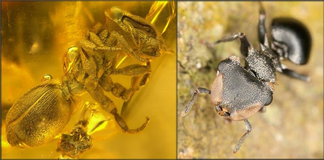
An ant preserved in amber and its modern counterpart. Credit: OIST
“Imagine I could send an ecologist to Europe back tens of millions of years ago. Then, ask them to look at the ants and to tell me where they think they have landed… They would say South East Asia,” explains Prof. Evan Economo of the Okinawa Institute of Science and Technology Graduate University (OIST). His team compared a database of modern ants with a database of fossil ants. The analysis has shown in which locations fossilized ants are more related to the ants now living in the same area of the world. Interestingly, ants which lived in Europe 45 to 10 million years ago were more similar to modern ants now living in South East Asia than their European counterparts. The study has been published in the Journal of Biogeography.
The team, including Economo’s former post-doc and now assistant professor at the University of Hong Kong Benoit Guénard and associate professor Vincent Perrichot of the Université de Rennes, is studying why we encounter certain groups of ants, in specific regions on Earth, and how their distribution has changed over time. Understanding the worldwide distribution of biodiversity is one of the biggest challenges for biogeographers and ecologists. “Many biologists tend to perceive biodiversity as a fixed image while in fact it is a very long movie and we don’t understand the full story yet. Getting more snapshots of this movie will help us to reconstruct the teaser trailer of life” Guénard said.
Today’s biodiversity evolved over millions of years and although invertebrates count for two thirds of Earth life, large scale analyses are still scarce. “To understand the present we need to consider history,” suggests Prof Economo. The three biologists combined a fossil ant database with a modern ant database including 1,060 publications, over 4,000 worldwide sites and several fossil deposits to compare the geographical distribution of modern ants with their ancestors. “Until recently scientists were able to talk about the characteristics of ants fossils, but it is only thanks to new informatics tools that we are able to combine and quantify a huge amount of data” continues Economo.
The integration of these two databases shows interesting differences and similarities between the geographical distribution of ancient and modern ants. For example, fossil ants which once lived in Europe were more comparable with modern South East Asian, Indian or even Australian ants, rather than with the ants currently populating Europe or Africa. During most of the Cenozoic era and especially at its earliest period, around 60 to 5 million years ago, the Earth was much warmer. Tropical forests covered most of the globe, including Europe, and even Antarctica was covered with vegetation. In those days Europe was a tropical rainforest with a completely different ecosystem from the one we see today. Then, climate shifts, continent re-arrangements, and ecological variations caused large scale extinctions in some parts of the world. Ants adapted to warm climate were not able to survive in cooler temperatures. The data also showed evidence of continent-wide extinctions. For example, ants that were once globally widespread are now restricted only to Sri Lanka.
These results help scientists to go a step closer into the interpretation of the “tree of life,” that is the network of the relationships between living and extinct organisms across the globe. “If we can get a better understanding of the climate in the past, of the consequences of climate change and of how it shaped communities, then we might be able to interpret the future of biodiversity under the current climate change scenario,” says Guénard.
Reference:
Benoit Guénard, Vincent Perrichot, Evan P. Economo. Integration of global fossil and modern biodiversity data reveals dynamism and stasis in ant macroecological patterns. Journal of Biogeography, 2015; DOI: 10.1111/jbi.12614
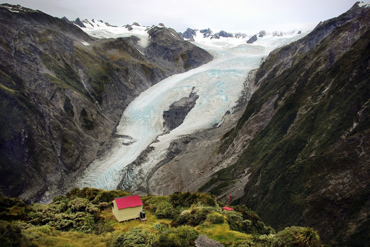
Franz Josef Glacier (Kā Roimata o Hine Hukatere). Credit: B Lehmann, University of Lausanne, Switzerland
It’s a truism that mathematical relationships are present nearly everywhere in nature, probably more than we realise. The latest place they have turned up is on the underside of glaciers.
A group of international scientists working on Franz Josef Glacier (Kā Roimata o Hine Hukatere) in the South Island has found that the rate of glacial erosion is proportional to the square of the glacier’s speed. They describe this as non-linear behaviour.
In other words, fast moving glaciers or portions of glaciers erode much more rock than slow moving glaciers. The finding confirms a theoretical model that was first proposed in the 1970s.
It means that as the Earth gets warmer and glaciers accelerate, the rate of glacial erosion will increase. A result will be more rapid carving of our landscape by glaciers with a corresponding increase in the levels of sediment and mud carried in alpine streams and rivers.
The finding applies to faster-moving glaciers in mountainous mid-latitude regions, but may not apply to polar glaciers that move more slowly.
The research is the cover story in this week’s issue of the prestigious journal Science, and involved a collaboration among scientists from Switzerland, France, the United States, and New Zealand.
Co-author on the paper, Dr Simon Cox of GNS Science, said non-linear behaviour explained the wide range of observed glacial erosion rates and also the profound impact of glaciation on mountainous landscapes during the past few millions years.
“The erosive power of glaciers varies considerably, with some of the most rapid glacial erosion happening in mid-latitude climates,” Dr Cox said.
“This research confirms that fast glaciers are more effective at gouging landscapes than slow-moving ones.”
Although the process of glaciation is widespread in the landscape, scientists don’t fully understand it, partly because of the great difficulty accessing the ice-bedrock interface underneath glaciers.
In the study of the Franz Josef Glacier (Kā Roimata o Hine Hukatere), which took place over a five-month period in 2013 and 2014, the scientists used a combination of two techniques to shed light on the glacier’s behaviour.
First they used satellite imagery to measure the speed of the glacier at its surface, which reaches up to 3 m/day. At the same time, they analysed the crystalline structure of carbon-bearing particles – mostly graphite – collected from the meltwater river below the glacier.
To do this they used a method called Raman spectroscopy which involves measuring the way light is scattered when it interacts with carbonaceous particles. They then used the ‘Raman signature’ to track particles back to the bands of Alpine Schist rocks from where each particle was eroded.
This enabled them to quantify erosion rates beneath the glacier. From the results, they have developed a law for glacial erosion that captures the variability seen globally, in different climate zones.
Their work shows erosion is highly sensitivity to small variations in topographic slope and rainfall.
Dr Cox said the power demonstrated by the combination of techniques will enable scientists to better understand glacial erosion and how this will change as our glaciers respond to global warming.
Note: The new law for the erosive power of glaciers is redolent of Einstein’s famous E = MC2 equation. The glacier equivalent is E = KV2 where E is the erosion rate of the glacier, K is the erodibility or strength of the underlying rock, and V is the speed of the glacier, or part of the glacier, in meters per day.
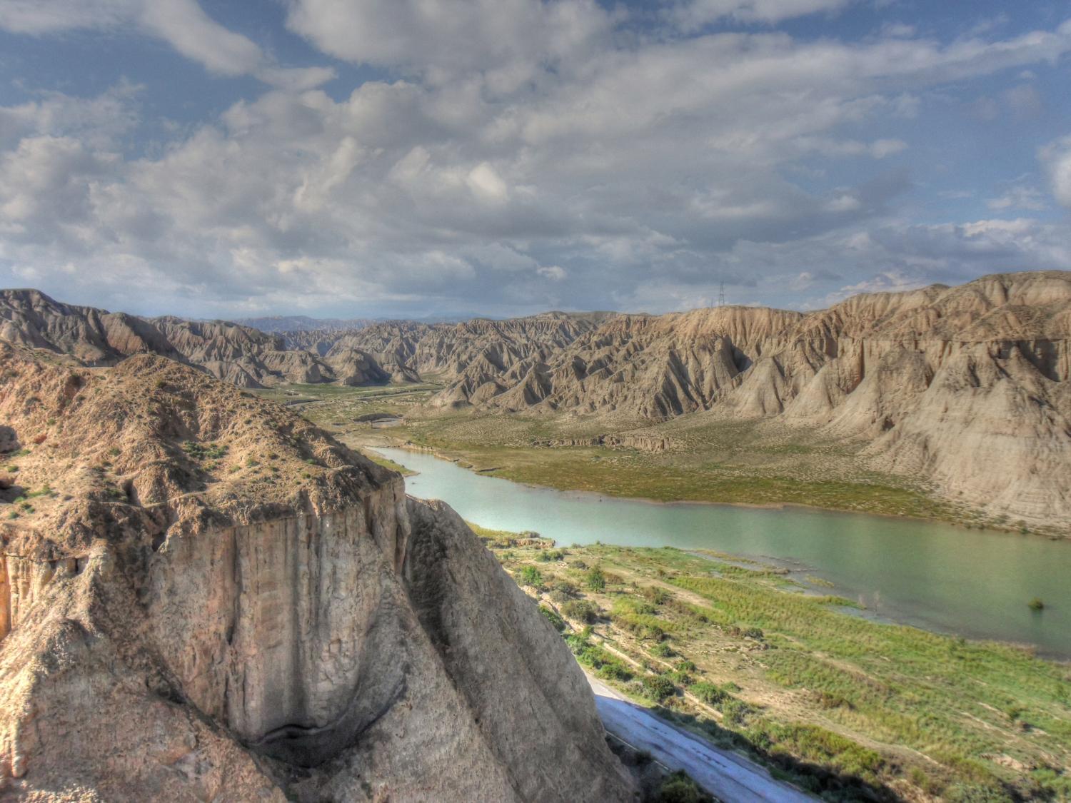
This is a side branch of the Yellow River on the north east edge of the Tibetan plateau. Our recent work shows that the Yellow River eroded and incised the uplifting Tibetan plateau and provided the wind-blown dust material that forms the Chinese Loess Plateau, one of the worlds most important past climate archives. Credit: Thomas Stevens
By meticulously examining sediments in China’s Yellow River, a Swedish-Chinese research group are showing that the history of tectonic and climate evolution on Earth may need to be rewritten. Their findings are published today in the highly reputed journal Nature Communications.
To reconstruct how the global climate and topography of the Earth’s surface have developed over millions of years, deposits of eroded land sediment transported by rivers to ocean depths are often used. This process is assumed to have been rapid and, by the same token, not to have resulted in any major storages of this sediment as large deposits along the way.
However, knowledge gaps and contradictory data in research to date are impeding an understanding of climate and landscape history. In an attempt to fill the gaps and reconcile the contradictions, the researchers have been investigating present-day and ancient sediment deposits in the world’s most sediment-rich river: the Yellow River in China.
The researchers, from Uppsala University (led by Dr. Thomas Stevens) and Lanzhou University (led by Dr. Junsheng Nie), China, analysed Yellow River sediment from source to sink and determined its mineral composition. They also determined the age of mineral grains of zircon, a very hard silicate mineral that is highly resistant to weathering.
Zircon ages serve as a unique fingerprint that yields information about the sources of these sediment residues from mountain chains, according to Thomas Stevens of Uppsala University’s Department of Earth Sciences, one of the principal authors of the study.
The Yellow River is believed to gain most of its sediment from wind-blown mineral dust deposits called loess, concentrated on the Chinese Loess Plateau. This plateau is the largest and one of the most important past climate archives on land, and also records past atmospheric dust activity: a major driver of climate change.
The scientists found that the composition of sediment from the Yellow River underwent radical change after passing the Chinese Loess Plateau. Contrary to their expectations, however, the windborne loess was not the main source of the sediment. Instead, they found that the Loess Plateau acts as a sink for Yellow River material eroded from the uplifting Tibetan plateau.
This finding completely changes our understanding of the origin of the Chinese Loess Plateau. It also demonstrates large scale sediment storage on land, which explains the previously contradictory findings in this area.
‘Our results suggest that a major change in the monsoon around 3.6 million years ago caused the onset of Yellow River drainage, accelerated erosion of the Tibetan plateau and drove loess deposition,’ Thomas Stevens writes.
Weathering of this eroded material also constitutes a further mechanism that may explain the reduced levels of atmospheric carbon dioxide at the beginning of the Ice Age. The researchers’ next step will be to compare terrestrial and marine records of erosion to gauge how far sediment storage on land has impacted the marine record.
‘Only then will we be able to assess the true rates of erosion and its effect on atmospheric CO2 and thus the climate in geologic time,’ says Stevens.
Reference:
Junsheng Nie, Thomas Stevens, Martin Rittner, Daniel Stockli, Eduardo Garzanti, Mara Limonta, Anna Bird, Sergio Andò, Pieter Vermeesch, Joel Saylor, Huayu Lu, Daniel Breecker, Xiaofei Hu, Shanpin Liu, Alberto Resentini, Giovanni Vezzoli, Wenbin Peng, Andrew Carter, Shunchuan Ji & Baotian Pan. Loess Plateau storage of Northeastern Tibetan Plateau-derived Yellow River sediment. DOI:10.1038/ncomms9511
Note: The above post is reprinted from materials provided by Uppsala University.
Experts have described one of the most complete sauropod dinosaur braincases ever found in Europe. The find could help scientists uncover some of the mysteries of how dinosaur brains operated, including their intellectual and sensory abilities.
The team have digitally reconstructed the cavity where the brain lay, the passages of the cranial nerves and certain blood vessels as well as the labyrinth of the inner ear.
In a paper published today in the journal PLOS ONE, the team led by a senior research fellow from The University of Manchester, and including Larry Witmer (Ohio University), Ryan Ridgely (Ohio University), Francisco Ortega (UNED) and Jose Luis Sanz (UAM) describes the rare find. Skulls, and particularly the braincases, are very fragile so not many have survived. That is not the case with this find, which is remarkably complete.
The skull, from a titanosaur, a type of sauropod, was found at a dig site in eastern Spain in 2007 and experts have spent the last few years studying it to see what secrets it may reveal.
Lead author of the paper Dr Fabien Knoll, of The University of Manchester, said: “This is such a rare finding that is why it is so exciting. Usually we find vertebrae or other bones, very rarely the braincase and this one is complete. I was present on the dig site when it was uncovered and it was a very special moment.
“Currently we know very little about the brain of dinosaurs. Research such as this is fundamental if we want to get an idea about the cognitive skills of these animals or if they had keen hearing or good eyesight and plenty of other information.”
The titanosaur lived about 72 million years ago. Like all sauropods it was four-legged with a long neck and a long tail and herbivorous. It was a distant relative of Diplodocus but, with about 14m in length, was only half its size. The study shows that its brain fitted in a diminutive cavity of only 6.3 cm in length.
Dr Knoll, who made the first digital reconstruction of a dinosaur endocranial cavity in the late 1990s, said: “In a few years’ time if more finds like this come to light and, above all, if they are studied with the modern imaging technologies then we could really start to understand more about dinosaur brains.”
Reference:
Fabien Knoll et al. “A New Titanosaurian Braincase from the Cretaceous “Lo Hueco” Locality in Spain Sheds Light on Neuroanatomical Evolution within Titanosauria,” PLOS ONE (2015). DOI: 10.1371/journal.pone.0138233
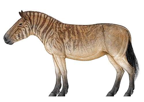
Fig. 1 Reconstruction of Hipparion tchikoicum. Credit: Chen Yu
Hipparionine horses were extensively distributed in North America and the Old World, and they were especially abundant during the Late Miocene and Pliocene in Eurasia. As a result, Hipparion fossils are important biological markers for stratigraphic correlations as well as climatic and environmental reconstructions. The fossils of the genus Hipparion are the most representative in the Late Miocene and Pliocene terrestrial strata of China, and their rich specimens are found in many fossil localities. Like most localities bearing Hipparion in China, the Hipparion fossils in central Inner Mongolia were collected from the red clay deposits, such as Tuchengzi in Huade County and Wulanhua in Siziwang Banner. From the fluvial and lacustrine deposits of central Inner Mongolia, a great number of micromammalian localities have been discovered, in which sporadic Hipparion fossils were mentioned, without specific reports and detailed descriptions.
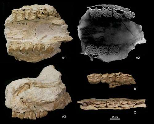
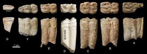
Deng and his colleagues reported Hipparion (Baryhipparion) tchikoicum from the Late Miocene deposits at Baogeda Ula in Abag Banner, Inner Mongolia, China in the latest issue of Historical Biology online, an international journal of paleobiology. The deep ectoflexids of the premolars and the rounded double-knots of the lower cheek teeth place the Baogeda Ula specimens in the primitive forms of Hipparion in Eurasia. The two North American species of Hipparion, H. shirleyi and H. tehonense with deep ectoflexids and rounded double-knots in the lower premolars, may be the ancestral forms of the subgenus Baryhipparion. The new discovery made the Eurasian expansion of this subgenus clear: it first appeared in North China during the latest Miocene, and then spread northward to the Mongolian Plateau and Transbaikalia; it migrated westward into Europe through Kazakhstan and Caucasus in the Pliocene; and it survived in Transbaikalia until the Early Pleistocene.
The Baogeda Ula site is located 6 km from Baogeda Ula Sumu (Sumu means Township in Mongolian) in Abag Banner, Inner Mongolia. The exposed strata are a series of variegated fluvial and lacustrine mudstones, with a visible thickness of more than 100 m, covered by a thick layer of basalts on the top. Baogeda Ula has the only Hipparion record in eastern Asia that is associated with a layer of basalt. In the field work of 2007, the IVPP team found a maxillary and some isolated teeth of Hipparion from Baogeda Ula. In 2009, an excavation found more Hipparion fossils, including upper and lower jaws of juvenile individuals, isolated teeth, and bone fragments from this site. The main features of these specimens include large size, short and rounded protocones, deep ectoflexids in lower premolars, and rounded double-knots. These characters are consistent with the diagnosis of Hipparion (Baryhipparion) tchikoicum.
Hipparion tchikoicum belongs to the subgenus Baryhipparion, a primitive group of hipparionine horses that occurs mostly in the Pliocene of northern Eurasia. The discovery of more localities bearing H. tchikoicum is beneficial for us to understand the zoogeographical significance of the subgenus Baryhipparion. Furthermore, the Baogeda Ula Hipparion connects the distribution of this species in the Yushe Basin and Mongolia.
H. tchikoicum was earlier than H. insperatum chronologically, and the distribution of the former started from the latest Baodean because the specimens of H. tchikoicum were collected from the variegated clays at the top of the Mahui Formation at Ouniwa. At the type locality of H. insperatum, the exposed strata are the top of the Gaozhuang and Mazegou formations. The geological age of the late Cenozoic strata has been well dated, with concluded that the boundary between the Mahui and Gaozhuang formations being at 5.7 Ma, so the first appearance of H. tchikoicum should be around 6 Ma. This age is a good reference for the Baogeda Ula Hipparion. Combining the dating of the basalts and the micromammalian fossils below the horizon of the Hipparion layer, the age of the Hipparion bed at Baogeda Ula should be 6 Ma.
Fig. 3 Juvenile maxillary and deciduous teeth of Hipparion tchikoicum from Baogeda UlaFig. 4 Lower teeth of Hipparion tchikoicum from Baogeda Ula
The inner core is Earth’s deepest layer. It is a ball of solid iron just larger than Pluto which is surrounded by a liquid outer core. The inner core is a relatively recent addition to our planet and establishing when it was formed is a topic of vigorous scientific debate with estimates ranging from 0.5 billion to 2 billion years ago. Credit: Kay Lancaster, Department of Earth, Ocean and Ecological Sciences
There have been many estimates for when the earth’s inner core was formed, but scientists from the University of Liverpool have used new data which indicates that the Earth’s inner core was formed 1 — 1.5 billion years ago as it “froze” from the surrounding molten iron outer core.
The inner core is Earth’s deepest layer. It is a ball of solid iron just larger than Pluto which is surrounded by a liquid outer core. The inner core is a relatively recent addition to our planet and establishing when it was formed is a topic of vigorous scientific debate with estimates ranging from 0.5 billion to 2 billion years ago
In a new study published in Nature, researchers from the University’s School of Environmental Sciences analysed magnetic records from ancient igneous rocks and found that there was a sharp increase in the strength of the Earth’s magnetic field between 1 and 1.5 billion years ago.
This increased magnetic field is a likely indication of the first occurrence of solid iron at Earth’s centre and the point in Earth’s history at which the solid inner core first started to “freeze” out from the cooling molten outer core.
Liverpool palaeomagnetism expert and the study’s lead author, Dr Andy Biggin, said: “This finding could change our understanding of the Earth’s interior and its history.”
“The timing of the first appearance of solid iron or “nucleation” of the inner core is highly controversial but is crucial for determining the properties and history of the Earth’s interior and has strong implications for how the Earth’s magnetic field — which acts as a shield against harmful radiation from the sun, as well as a useful navigational aid — is generated.
“The results suggest that the Earth’s core is cooling down less quickly than previously thought which has implications for the whole of Earth Sciences. It also suggests an average growth rate of the solid inner core of approximately 1mm per year which affects our understanding of the Earth’s magnetic field.”
The Earth’s magnetic field is generated by the motion of the liquid iron alloy in the outer core, approximately 3,000 km beneath the Earth’s crust. These motions occur because the core is losing heat to the overlying solid mantle that extends up to the crust on which we live producing the phenomenon of convection.
Once the inner core started to freeze, this convection received a strong boost in power because light, non-metallic elements remained molten in the outer core and were buoyant relative to the overlying liquid. The process continues today and is thought to be the main source of “fuel” for generating the Earth’s magnetic field.
Dr Biggin added: “The theoretical model which best fits our data indicates that the core is losing heat more slowly than at any point in the last 4.5 billion years and that this flow of energy should keep the Earth’s magnetic field going for another billion years or more.
“This contrasts sharply with Mars which had a strong magnetic field early in its history which then appears to have died after half a billion years.”
The study, published in the journal Nature, is a collaboration between scientists at the Universities of Liverpool, Helsinki, Michigan Tech, UC San Diego, and the Chinese Academy of Sciences.
Reference:
A. J. Biggin, E. J. Piispa, L. J. Pesonen, R. Holme, G. A. Paterson, T. Veikkolainen, L. Tauxe. Palaeomagnetic field intensity variations suggest Mesoproterozoic inner-core nucleation. Nature, 2015; 526 (7572): 245 DOI: 10.1038/nature15523
The third cervical vertebra of the modern giraffe. This species underwent both stages of elongation, which are responsible for its extremely long neck. Credit: Nikos Solounias
Scientists have long theorized that the long neck of modern-day giraffes evolved to enable them to find more vegetation or to develop a specialized method of fighting.
A new study of fossil cervical vertebrae reveals the evolution likely occurred in several stages as one of the animal’s neck vertebrae stretched first toward the head and then toward the tail a few million years later. The study’s authors say the research shows, for the first time, the specifics of the evolutionary transformation in extinct species within the giraffe family.
“It’s interesting to note that that the lengthening was not consistent,” said Nikos Solounias, a giraffe anatomy expert and paleontologist at NYIT College of Osteopathic Medicine. “First, only the front portion of the C3 vertebra lengthened in one group of species. The second stage was the elongation of the back portion of the C3 neck vertebra. The modern giraffe is the only species that underwent both stages, which is why it has a remarkably long neck.”
The study, which includes a computational tracking model of the evolutionary elongation, is published in Royal Society Open Science.
Solounias and Melinda Danowitz, a medical student in the school’s Academic Medicine Scholars program, studied 71 fossils of nine extinct and two living species in the giraffe family. The bones, discovered in the late 1800s and early 1900s, were housed at museums around the world, including those in England, Austria, Germany, Sweden, Kenya, and Greece.
“We also found that the most primitive giraffe already started off with a slightly elongated neck,” said Danowitz. “The lengthening started before the giraffe family was even created 16 million years ago.”
But the main discovery came after the researchers analyzed anatomical features of the various fossils and compared them to the evolutionary tree.
“That’s when we saw the stages playing out,” said Danowitz.
Solounias and Danowitz found the cranial end of the vertebra stretched initially around 7 million years ago in the species known as Samotherium, an extinct relative of today’s modern giraffe. That was followed by a second stage of elongation on the back or caudal portion around one million years ago. The C3 vertebra of today’s giraffe is nine times longer than its width — about as long as an adult human’s humerus bone, which stretches from the shoulder to the elbow.
As the modern day giraffe’s neck was getting longer, the neck of another member of the giraffe family was shortening. The okapi, found in central Africa, is the only other living member of the giraffe family. Yet, rather than evolving a long neck, Danowitz said this species is one of four with a “secondarily shortened neck,” placing it on a different evolutionary pathway.
The researchers next study area is the evolution of the giraffe’s long leg bones.
Reference:
Melinda Danowitz, Aleksandr Vasilyev, Victoria Kortlandt, Nikos Solounias. Fossil evidence and stages of elongation of the Giraffa camelopardalis neck. Royal Society Open Science, 2015 DOI: 10.1098/rsos.150393