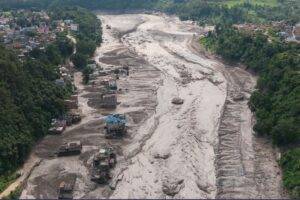
Stringer/Reuters
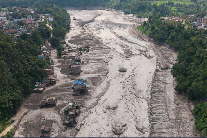
On August 26, 2026, a catastrophic flash flood swept through the Himalayan border region of Nepal and Tibet, causing severe destruction along the Lhende Khola–Bhote Koshi–Trishuli river system. Settlements, roads, bridges, hydropower infrastructure, and sections of the trans-Himalayan transport corridor were damaged or destroyed, while rescue operations continued amid extensive loss of life and large numbers of missing people.
The disaster was unusual because available hydrological evidence does not support an intense local rainstorm as its primary trigger. Nepal’s Department of Hydrology and Meteorology reported that there had not been heavy rainfall in the affected Rasuwa area immediately before the flood. Instead, satellite imagery, seismic observations, and preliminary assessments point toward a large high-altitude ice-rock mass movement that entered the Lhende Khola catchment and initiated a cascading sequence of processes.
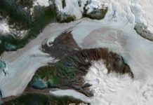
Satellite imagery reviewed by scientists indicates that a substantial portion of the lower part of a glacier detached at approximately 5,200 metres elevation and descended roughly 1,200 vertical metres toward the valley floor. The collapsing ice appears to have entrained rock and sediment, creating an ice-rock avalanche rather than a simple fall of clean glacier ice.
Preliminary satellite analysis by Nepal’s Department of Hydrology and Meteorology further suggests that the avalanche and associated debris may have temporarily blocked the river about 20 km upstream of the Miteri Bridge, producing an impoundment that subsequently released water downstream. This river-blockage interpretation is plausible and supported by early imagery, but it remains a preliminary reconstruction rather than a fully resolved post-event model.
The Nepal flash flood of August 2026 is therefore best understood, at present, as a cascading cryospheric and geomorphic disaster: an initial glacier or ice-rock instability generated a large mass movement, the mass movement interacted with the river system, water and sediment were rapidly mobilized, and the resulting flood transformed as it moved through steep Himalayan valleys.
This distinction is important. The event was not simply “a glacier melting” and it should not yet be described uncritically as a conventional glacial lake outburst flood. Its destructive power appears to have emerged from the interaction of ice, rock, water, steep relief, temporary river obstruction, sediment entrainment, and confined valley geometry.
What Caused the August 2026 Nepal Flash Flood?
The Initial Ice-Rock Avalanche
The best available evidence indicates that the disaster began with the failure of a high-altitude glacier or glacier-associated slope in the Langtang–Nepal/Tibet border region.
Before-and-after Planet Labs imagery showed a major change in the source area. Researchers examining the images identified a substantial collapse from the lower glacier, followed by extensive deposits of fragmented ice, rock, and sediment on the valley floor. Reuters reported that Nepal’s National Disaster Risk Reduction and Management Authority described the event as a glacier-involved flood associated with a snow-rock or ice-rock mass movement in the upper Lhende drainage.
An ice-rock avalanche is a rapid gravitational mass movement containing substantial quantities of both glacier ice and rock debris. Such events can be extraordinarily mobile because fragmentation, ice deformation, entrained water, snow, and fine sediment reduce internal resistance during movement.
The physical process begins with gravitational potential energy:
Ep=mghE_p = mgh
where:
- EpE_p is gravitational potential energy
- mm is the mass of unstable material
- gg is gravitational acceleration
- hh is the vertical drop
For the August 2026 event, the reported vertical fall of approximately 1.2 km implies an enormous potential-energy release. However, a defensible event-specific energy calculation cannot yet be made because the three-dimensional failure volume, average thickness, rock-to-ice ratio, density, and entrained mass remain insufficiently constrained.
This is an important scientific limitation. Mapping the surface area of a collapse scar is not equivalent to determining the volume or mass of the failed material.
From Glacier Failure to a Valley-Scale Mass Flow
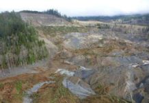
Once ice and rock began accelerating downslope, the moving avalanche likely fragmented and entrained additional material from the slope and valley floor.
Possible entrained materials include:
- unconsolidated glacial sediment
- moraine debris
- talus
- weathered bedrock
- snow
- channel sediment
- and river water
The result can be a rapidly evolving multiphase flow whose behavior changes with distance.
A comparable process was documented during the 2021 Chamoli disaster in the Indian Himalaya, when approximately 27 million m³ of rock and glacier ice collapsed and transformed into an exceptionally mobile debris flow. Shugar et al. (2021) showed that entrainment and flow transformation were fundamental to the downstream disaster. The Chamoli event should not be treated as an exact analogue for the 2026 Nepal flood, but it demonstrates the physical plausibility of an ice-rock avalanche evolving into a highly destructive valley-confined flow.
How River Blockage May Have Amplified the Disaster
Formation of a Temporary Natural Dam
One of the most significant findings in the preliminary reconstruction is evidence that ice and debris may have blocked the river.
Nepal’s Department of Hydrology and Meteorology reported that satellite images supplied by Chinese authorities showed a blockage approximately 20 km upstream of the Miteri Bridge. Officials interpreted the images as showing an icefall or landslide, formation of an impounded water body behind debris, and subsequent release.
A temporary blockage produced by an avalanche is known as a landslide dam, avalanche dam, or, where glacier ice is an important component, an ice-debris dam.
Unlike an engineered dam, such barriers are highly heterogeneous. They may contain a poorly sorted mixture of:
- boulders
- fractured bedrock
- gravel
- sand
- silt
- snow
- glacier ice
- and organic material
Their internal permeability and mechanical strength can vary dramatically over very short distances.
Why Temporary Landslide Dams Can Fail Rapidly
Water accumulating behind an avalanche deposit increases hydrostatic loading on the barrier. Failure may occur through several mechanisms, including overtopping, erosion of the downstream face, piping through permeable sediment, internal collapse, melting of ice-rich portions, or progressive channel incision.
Once overtopping begins, flowing water can rapidly erode an unconsolidated dam. As the breach deepens and widens, discharge rises, which accelerates erosion still further.
This positive feedback can generate an abrupt flood wave.
For the August 2026 event, the temporary-dam hypothesis is strongly supported by preliminary satellite interpretation, but researchers still need to determine the dimensions of the blockage, duration of impoundment, volume of stored water, breach mechanism, and relative contribution of other water sources.
Was the Nepal Flash Flood Caused by an Earthquake?
The Early Earthquake Interpretation
During the first hours after the disaster, a seismic signal detected near the Nepal–Tibet border was reported as a magnitude 4.4 earthquake. This immediately raised the possibility that tectonic shaking had destabilized the glacier or slope.
That interpretation changed as more data became available.
The U.S. Geological Survey subsequently revised the event, concluding that the seismic energy was generated by the glacier collapse and associated debris movement rather than by tectonic fault rupture. Reports based on the USGS reassessment state that the source was revised to a seismic magnitude of about 5.2 and classified as a glacial collapse/debris-flow event rather than an earthquake.
This distinction is fundamental.
A magnitude assigned to a seismic source describes the size of the recorded seismic signal; it does not automatically mean that the source was an earthquake produced by fault slip.
How Seismologists Distinguish Landslides from Earthquakes
Large landslides, rock avalanches, and glacier collapses can generate seismic waves detectable hundreds or even thousands of kilometres away.
The source physics, however, differs from that of a conventional tectonic earthquake.
In a typical tectonic earthquake, elastic strain is suddenly released by slip on a fault. The seismic source is commonly represented by a double-couple moment tensor.
A large landslide or avalanche instead produces ground forces as a moving mass accelerates, interacts with topography, changes direction, impacts the valley floor, and decelerates. For sufficiently large events, these dynamics can often be approximated using time-dependent single-force or centroid-force models.
Ekström and Stark (2013) demonstrated that long-period seismic waves produced by very large landslides can be inverted to estimate properties such as the duration, momentum, direction, potential-energy loss, and approximate mass of the moving material.
Scientists therefore do not identify a glacier collapse using one simple signal characteristic. Instead, they integrate seismic waveform and spectral behavior, arrival characteristics, long-period source modeling, event location, and independent geomorphic observations such as satellite imagery.
For the August 2026 event, reports indicate that the USGS reassessment incorporated data from nearby seismic stations, long-period seismic observations, and satellite evidence.
This multi-dataset approach is more robust than interpreting the seismic magnitude alone.
Was the August 2026 Event a Glacial Lake Outburst Flood?
What Is a GLOF?
A glacial lake outburst flood, commonly abbreviated GLOF, occurs when water stored in a glacier-related lake is released suddenly.
The lake may be dammed by:
- moraine
- glacier ice
- bedrock
- landslide debris
- or combinations of these materials
A GLOF can be triggered by an ice avalanche entering a lake, rockfall, moraine failure, intense rainfall, rapid snowmelt, earthquake shaking, internal piping, or progressive instability.
Why the Classification of the 2026 Flood Requires Caution
Calling the August 2026 Nepal event a conventional GLOF may be premature.
Early investigations considered whether a pre-existing glacial lake had burst, partly because the region contains glacial lakes and has experienced previous outburst floods. However, the more recent preliminary reconstruction emphasizes an ice-rock avalanche followed by river blockage and temporary impoundment. Nepalese officials have stated that whether an additional glacial lake outburst occurred remains under investigation.
At present, the most scientifically cautious terminology is:
an ice-rock-avalanche-triggered cascading flash flood, potentially involving temporary river damming and outburst.
If later investigations demonstrate that the dominant floodwater originated from a pre-existing glacier-fed lake, classification as a GLOF would become more appropriate.
If instead the main reservoir formed only after avalanche debris blocked the river, the process would be more accurately described as an avalanche-dammed or landslide-dam outburst flood.
The distinction is not semantic. Different mechanisms require different monitoring strategies.
Why Was the Flood So Destructive?
Extreme Himalayan Relief
The Himalaya provides ideal topographic conditions for rapid conversion of gravitational potential energy into destructive mass movement.
The suspected source material fell approximately 1,200 vertical metres from the glacier toward the valley below. Such relief allows an avalanche to accelerate rapidly before reaching the channel system.
Once the moving mass enters a narrow valley, it can maintain substantial momentum while simultaneously entraining sediment and water.
Sediment Entrainment and Flow Bulking
A flood originating upstream does not necessarily maintain a constant volume as it travels downstream.
In steep mountain channels, energetic flows can erode:
- channel banks
- river terraces
- alluvium
- landslide deposits
- moraines
- road embankments
- and previously deposited debris
This process is known as entrainment or bulking
As more sediment becomes incorporated, the flow may increase in density and destructive power.
The preliminary Nepalese assessment specifically noted that the large quantity of sediment transported with the flood substantially increased its destructive effect compared with a clear-water flood.
Transition Between Flood and Debris-Flow Behavior
Mountain floods exist along a continuum.
At relatively low sediment concentrations, the flow behaves predominantly as turbulent water. As sediment concentration increases, interactions between particles become increasingly important.
Conceptually, the system may evolve through:
water flood → sediment-laden flood → hyperconcentrated flow → debris-flow-like behavior
These categories should not be assigned to the August 2026 event without quantitative sediment-concentration measurements, but imagery clearly indicates that the surge transported large quantities of mud, rock, and boulders.
Such sediment-rich flows can exert enormous impact forces on bridges, hydropower structures, buildings, and retaining walls.
Why Did the Flood Remain Powerful Far Downstream?
Channel Confinement
The Bhote Koshi and upper Trishuli systems pass through steep, confined Himalayan valleys.
In a broad floodplain, floodwater can spread laterally, reducing depth and velocity. In a narrow gorge, the same discharge is concentrated into a much smaller cross-sectional area.
This confinement can maintain high flow velocities and depths for substantial distances.
Rapid Flood-Wave Propagation
Hydrological observations illustrate the unusual speed of the August 2026 surge.
According to ICIMOD information reported by Reuters, water levels at Galchhi on the Trishuli River rose by as much as approximately nine metres within about 30 minutes.
Such a rapid change is consistent with an abrupt upstream release rather than slowly developing rainfall runoff.
The flood also propagated through the Bhote Koshi into the Trishuli system and altered river corridors well downstream from its source.
Why the Lhende–Bhote Koshi Region Is Particularly Hazardous
Active Tectonics and Extreme Relief
The Himalaya exists because of the ongoing convergence between the Indian and Eurasian plates.
Continued crustal shortening and uplift, combined with rapid river incision, maintain very high topographic relief. The resulting landscape contains steep slopes, deeply incised valleys, fractured bedrock, and large volumes of unconsolidated sediment.
These conditions naturally favor:
- landslides
- rock avalanches
- debris flows
- glacier avalanches
- river blockage
- and catastrophic sediment transport
This does not mean tectonic activity directly triggered the August 2026 collapse. Rather, tectonics creates the steep and mechanically complex landscape in which such gravitational hazards occur.
Cryospheric Instability
High Himalayan valleys contain glaciers, seasonal snow, permafrost, moraines, and glacier-fed lakes. These components respond differently to temperature, precipitation, and long-term climate change.
A destabilized glacier can therefore interact with an unstable slope, a river, or a lake to create compound or cascading hazards.
The 2026 disaster illustrates why hazard assessment cannot treat glaciers, landslides, and floods as independent processes.
Previous Glacier-Related Floods in the Central Himalaya
The Poiqu–Bhote Koshi Transboundary Hazard Corridor
The broader central Himalayan border region has a documented history of glacier-related flooding.
Wang et al. (2024) reconstructed the 2002 Poiqu No. 1 GLOF and the 2016 Gongbatongsha Co GLOF in the transboundary Poiqu River basin. Their analysis showed that ice avalanches were the dominant triggers for both events and that the resulting floods underwent complex downstream flow transformations.
This is directly relevant to the August 2026 disaster because it demonstrates that ice avalanches can serve as the first stage of destructive transboundary flood cascades in the central Himalaya.
The historical events do not prove the precise mechanism of the 2026 flood, but they provide an important geological framework for understanding the region’s susceptibility.
Lessons from the 2021 Chamoli Disaster
The 2021 Chamoli event provides another useful comparison.
Shugar et al. documented how a large rock-and-ice avalanche transformed into a highly mobile debris-rich flow that devastated downstream hydropower infrastructure. The study demonstrated how a hazard beginning on a remote high-altitude slope can rapidly evolve into a completely different process downstream.
The key lesson is that hazard classification at the source does not necessarily describe the hazard experienced downstream.
An ice avalanche can become a debris flow.
A landslide can form a dam.
A temporary lake can generate an outburst flood.
A flood can entrain enough sediment to acquire debris-flow-like characteristics.
This process chain is what geologists mean by a cascading hazard.
Did Climate Change Cause the Nepal Flash Flood?
What We Know About Himalayan Glacier Change
There is strong scientific evidence that Himalayan glaciers have undergone substantial mass loss during recent decades.
Maurer et al. (2019), using historical satellite imagery and modern digital elevation models across a roughly 2,000-km Himalayan transect, found that average glacier ice-loss rates approximately doubled between 1975–2000 and 2000–2016, consistent with regional atmospheric warming as the dominant large-scale driver.
Climate-driven changes can modify high-mountain hazards through several physical pathways:
- glacier thinning
- changing glacier geometry
- increased meltwater production
- changing subglacial water pressure
- loss of ice support from valley walls
- permafrost degradation
- changing freeze–thaw conditions
- and growth or formation of glacier-fed lakes
These mechanisms make a climatic influence on Himalayan slope and glacier stability scientifically plausible.
Why Event Attribution Requires More Evidence
However, there is an important difference between saying that climate change modifies the regional hazard environment and claiming that it directly caused one particular collapse.
The exact trigger of the August 2026 initial failure remained under investigation on August 27. Scientists quoted by Reuters cautioned against attributing the collapse to climate change as a single immediate cause.
Possible controlling factors include glacier geometry, bed conditions, meltwater pressure, rock structure, snow conditions, preceding temperature, progressive deformation, and other local processes.
Some of these variables may themselves be influenced by long-term warming, but a scientifically defensible attribution requires event-specific evidence.
The safest conclusion is therefore:
Climate change is altering the physical conditions of the Himalayan cryosphere and can increase susceptibility to some glacier and slope failures, but the specific causal contribution of climate change to the August 2026 collapse has not yet been quantified.
What Previous Glacier Collapses Tell Us
The possibility of climate and hydrological forcing influencing glacier collapse is well established scientifically.
Kääb et al. (2018) investigated two enormous glacier collapses in western Tibet in 2016. They found that climate- and weather-related forcing interacted with unusual glacier-bed properties, subglacial water, and glacier dynamics to produce catastrophic failure.
This demonstrates that climate can be one component of a glacier-instability mechanism without functioning as a simple, isolated trigger.
That distinction should also guide interpretation of the 2026 Nepal flood.
The Role of Permafrost and Rock-Slope Instability
Frozen Ground as Part of Mountain Strength
High mountain bedrock commonly contains fractures filled with ice.
Where permafrost is present, ice within fractures can contribute to the mechanical behavior of rock slopes. Warming and thawing may change fracture-water pressure, reduce ice bonding, and promote progressive rock-mass instability.
However, the presence, depth, and thermal state of permafrost at the exact 2026 source zone have not yet been sufficiently documented to claim that permafrost degradation triggered the event.
It should therefore be treated as a possible regional process, not an established event-specific cause.
Glacier Debuttressing
As glaciers thin or retreat, they can expose valley walls that were previously in contact with glacier ice.
This process is commonly termed debuttressing.
The mechanical importance of glacier buttressing differs greatly between sites. Retreat does not automatically produce slope failure, but changing boundary conditions may contribute to long-term instability in already fractured mountain slopes.
Again, whether this process was important in the August 2026 source area remains to be tested.
What Satellite Imagery Reveals About the Disaster
Mapping the Source Scar
High-resolution satellite imagery is especially important in remote Himalayan disasters because the source area may be inaccessible for days or weeks.
Before-and-after imagery can identify:
- newly exposed failure scars
- missing glacier sections
- avalanche deposits
- newly formed lakes
- channel blockages
- sediment fans
- altered river courses
- and downstream inundation
Planet Labs imagery provided some of the first strong evidence that a major glacier-associated collapse had occurred during the August 2026 event.
Why Satellite Imagery Must Be Combined With Other Data
Satellite imagery alone cannot fully determine:
- the exact timing of failure
- the total avalanche volume
- water discharge
- subsurface conditions
- dam-breach dynamics
- or the complete sequence of events
A robust reconstruction therefore combines remote sensing with:
- seismic records
- river-stage measurements
- digital elevation models
- field mapping
- sedimentological evidence
- eyewitness videos
- and numerical flow models
This multidisciplinary strategy was successfully used after the 2021 Chamoli event and in reconstructions of previous central Himalayan GLOFs.
What Geological Evidence Will Researchers Look for Next?
Source-Area Reconstruction
Scientists will need high-resolution topographic data to calculate the true three-dimensional geometry of the failed glacier and slope.
Comparing pre- and post-event digital elevation models can constrain:
- failure volume
- ice-versus-rock proportions
- vertical displacement
- erosion
- and deposit thickness
These values are necessary for credible energy and mass-balance calculations.
Sedimentological Evidence
Downstream deposits can reveal how the flow changed with distance.
Geologists will examine:
- grain-size distributions
- boulder imbrication
- matrix-supported versus clast-supported textures
- scour surfaces
- mud drapes
- high-water marks
- channel erosion
- and sediment thickness
These observations can help distinguish sections dominated by debris flow, hyperconcentrated flow, and conventional flooding.
Evidence of Temporary Damming
If a temporary landslide dam controlled the flood, researchers should be able to identify geomorphic evidence such as:
- remnants of the blockage
- upstream sediment or water-level marks
- a breach channel
- erosional scarps
- lacustrine sediment
- and post-event channel reorganization
This evidence will be critical for determining whether the early dam-outburst interpretation is correct.
Can Similar Himalayan Flash Floods Be Predicted?
Hazard Identification Is Easier Than Exact Prediction
Scientists can identify unstable glaciers and potentially dangerous slopes, but predicting the exact time of catastrophic failure remains extremely difficult.
Possible indicators include:
- accelerating glacier motion
- widening crevasses
- progressive slope deformation
- growth of supraglacial ponds
- changing drainage pathways
- increasing rockfall
- unstable moraine dams
- and anomalous seismic activity produced by cracking or mass movement
No individual signal guarantees that failure will occur.
Monitoring Must Extend Beyond Glacial Lakes
Traditional Himalayan cryospheric hazard programs have often focused heavily on identifying large glacial lakes.
That remains essential, but events such as Chamoli and the preliminary reconstruction of the August 2026 Nepal flood demonstrate that catastrophic floods can originate without the straightforward failure of a previously mapped large lake.
Monitoring strategies should therefore include:
- hanging glaciers
- steep glacier termini
- ice-rock avalanche source zones
- permafrost slopes
- landslide dams
- supraglacial lakes
- glacier drainage systems
- and downstream sediment stores
The key concept is source-to-river connectivity.
Why Transboundary Monitoring Is Essential
Flood Basins Ignore Political Borders
The August 2026 disaster affected both Nepal and Tibet and propagated through a river system crossing politically sensitive mountainous terrain.
Upstream mass movements can generate downstream hazards before communities have enough time to understand what happened.
Effective warning therefore depends on rapid exchange of:
- seismic information
- river-gauge data
- satellite observations
- glacier monitoring
- meteorological measurements
- and reports of upstream blockage
The transboundary nature of previous Poiqu–Bhote Koshi GLOFs makes this need particularly clear.
Cascading-Hazard Warning Systems
A conventional flood warning system may detect rising river levels only after a catastrophic release has begun.
A more advanced system would integrate multiple sensors.
For example, a large mass movement detected seismically could automatically trigger analysis of satellite imagery and downstream river gauges. If both an avalanche signal and sudden river-stage rise were detected, alerts could be issued to communities farther downstream.
Such integrated systems are increasingly important in steep glacierized mountain regions.
Frequently Asked Questions About the August 2026 Nepal Flash Flood
What caused the Nepal flash flood in August 2026?
The best available evidence indicates that a large ice-rock avalanche associated with the collapse of part of a high-altitude glacier initiated the disaster. Preliminary satellite analysis also suggests that debris temporarily blocked the Lhende river system, allowing water to accumulate before a sudden downstream release. The detailed sequence is still being investigated.
Was an earthquake responsible for the flood?
Current USGS interpretation indicates no tectonic earthquake triggered the event recorded by its network. A signal initially catalogued as a magnitude 4.4 earthquake was subsequently reinterpreted as seismic energy generated by the glacier collapse and debris movement, with the source revised to approximately magnitude 5.2.
Does magnitude 5.2 mean there was a magnitude 5.2 earthquake?
No. Seismic magnitude does not by itself identify the physical source as an earthquake. Very large landslides and glacier collapses can generate strong seismic signals. Source modeling and independent geological evidence are needed to determine whether the signal resulted from fault rupture or gravitational mass movement.
Was the event a GLOF?
Possibly in a broad glacier-related sense, but a conventional pre-existing glacial lake outburst has not yet been conclusively demonstrated. The strongest current preliminary interpretation involves an ice-rock avalanche and temporary river blockage. It is therefore safer to describe the disaster as an ice-rock-avalanche-triggered cascading flood pending detailed investigation.
Did heavy rainfall cause the flood?
Heavy local rainfall does not currently appear to have been the primary trigger. Nepal’s Department of Hydrology and Meteorology reported that substantial rainfall had not occurred in the Rasuwa area immediately before the disaster.
Did climate change cause the glacier collapse?
The answer is not yet known. Climate warming is clearly driving major glacier changes across the Himalaya and can modify conditions controlling glacier and slope stability. However, determining how much climate change contributed to this specific collapse requires detailed event attribution.
Why was the flood carrying so much mud and rock?
The initial mass movement supplied large quantities of debris, while the high-energy downstream flow could also erode and entrain additional sediment from channels, riverbanks, terraces, and existing slope deposits. Preliminary observations indicate that sediment and boulders were a major component of the destructive surge.
What the August 2026 Nepal Flood Teaches Us About Himalayan Geology
The central scientific lesson from the disaster is that extreme Himalayan floods often cannot be explained by a single process.
The current evidence points toward a sequence resembling:
glacier or ice-rock instability → catastrophic mass movement → river interaction → probable temporary obstruction → rapid water release → sediment entrainment → debris-rich flood → downstream geomorphic transformation
Each stage can amplify the next.
This is why the term cascading geohazard is so important.
The August 2026 Nepal flash flood demonstrates that a failure beginning high on an isolated mountain slope can propagate through the landscape and become a regional hydrological disaster.
It also demonstrates why geological hazards cannot always be neatly separated into categories such as “landslide,” “glacial hazard,” and “flood.”
In steep mountain systems, they are dynamically connected.
References
- Shugar, D. H., Jacquemart, M., Shean, D., et al. (2021). A massive rock and ice avalanche caused the 2021 disaster at Chamoli, Indian Himalaya. Science, 373(6552), 300–306. doi: 10.1126/science.abh4455.
- Kääb, A., Leinss, S., Gilbert, A., et al. (2018). Massive collapse of two glaciers in western Tibet in 2016 after surge-like instability. Nature Geoscience, 11, 114–120. doi: 10.1038/s41561-017-0039-7.
- Maurer, J. M., Schaefer, J. M., Rupper, S., & Corley, A. (2019). Acceleration of ice loss across the Himalayas over the past 40 years. Science Advances, 5(6), eaav7266. doi: 10.1126/sciadv.aav7266.
- Ekström, G., & Stark, C. P. (2013). Simple scaling of catastrophic landslide dynamics. Science, 339(6126), 1416–1419. doi: 10.1126/science.1232887.
- Wang, X., Zhang, G., Veh, G., Sattar, A., Wang, W., Allen, S. K., Bolch, T., Peng, M., & Xu, F. (2024). Reconstructing glacial lake outburst floods in the Poiqu River basin, central Himalaya. Geomorphology, 449, 109063. doi: 10.1016/j.geomorph.2024.109063.