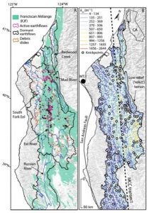
Landscapes are formed by a combination of uplift and erosion. Uplift from plate tectonics raises the land surface; erosion by rivers and landslides wears the land surface back down. In this study, Georgina L. Bennett and colleagues examine the interplay of uplift and erosion along the coast range of Northern California to understand how the modern topography is built.
This region is unique in that a wave of uplift is sweeping north through the Coast Range, allowing geoscientists to document the erosional response and assess the timescale of the process. Bennett and colleagues find that rivers cut down through the uplifting land surface, steepening surrounding hillslopes and triggering landslides when hillslope angles reach a limit.
Landslides are the main erosional process balancing uplift in the region. However, intriguingly, they may also have a negative feedback to ongoing erosion, through the delivery of large resistant rocks to rivers that act to armor the riverbed from ongoing erosion. Thus the erosion of parts of the Coast Ranges in response to uplift may be delayed. These findings have implications for understanding landscape evolution, as well as hazards such as landslides.
Reference:
Georgina L. Bennett, Scott R. Miller, Joshua J. Roering, David A. Schmidt. Landslides, threshold slopes, and the survival of relict terrain in the wake of the Mendocino Triple Junction. Geology, 2016; G37530.1 DOI: 10.1130/G37530.1
Note: The above post is reprinted from materials provided by Geological Society of America.


