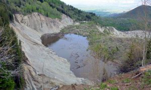
On 25 May 2014, a rain-on-snow-induced rock avalanche occurred in the West Salt Creek valley on the northern flank of Grand Mesa in western Colorado (United States). The avalanche mobilized from a preexisting rock slide in the Green River Formation and traveled 4.6 km down the confined valley, killing three people.
The 54.5 million cubic meter slide traveled those 4.6 km in about 3.5 minutes, with average velocities ranging up to 36 meters per second. The mobility of the avalanche was likely enhanced by liquefied valley-floor sediment.
This type and size of avalanche happens only rarely in the United States. To study the dynamics of the avalanche, Jeffrey A. Coe and colleagues from the U.S. Geological Survey used a novel combination of large-scale field mapping, unmanned aerial system (UAS) imagery, eyewitness accounts, and data from seismic stations located at distances up to 650 km away from the avalanche.
Their research shows that the avalanche had a complex series of movement phases, starting with a cascade of landslide/debris flow beginning about 10 hours before the catastrophic rock slide-avalanche phases, and ending with rock slides and rock falls from an oversteepened headscarp. These rock slides and rock falls are ongoing.
The results of this study can be applied to rock avalanche modeling and warning, monitoring of ongoing hazards at the site, and interpreting the emplacement velocity of paleo-landslide deposits.
Reference:
Rock-avalanche dynamics revealed by large-scale field mapping and seismic signals at a highly mobile avalanche in the West Salt Creek valley, western Colorado GEOSPHERE (2016). DOI: 10.1130/GES01265.1
Note: The above post is reprinted from materials provided by Geological Society of America.


. The av)