Hidden under the vegetation and crops of the Eria Valley, in León (Spain), there is a gold mining network created by the Romans two thousand years ago, as well as complex hydraulic works, such as river diversions, to divert water to the mines of the precious metal. Researchers from the University of Salamanca made the discovery from the air with an airborne laser teledetection system.
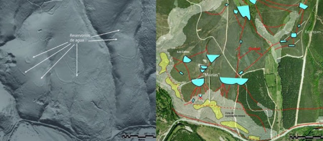
Las Médulas in León is considered to be the largest opencast goldmine of the Roman Empire, but the search for this metal extended many kilometres further south-east to the Erica river valley. Thanks to a Light Detection and Ranging (LiDAR) laser system attached to an aircraft, the ancient mining works of the area and the complex hydraulics system used by the Romans in the 1st century BC to extract gold (including channels, reservoirs and a double river diversion) have been discovered.
“The volume of earth exploited is much greater than previously thought and the works performed are impressive, having achieved actual river captures, which makes this valley extremely important in the context of Roman mining in the north-east of the Iberian Peninsula,” as Javier Fernández Lozano, geologist at the University of Salamanca and co-author of this study published in the Journal of Archaeological Science, said.
The specialists consider that the systems for the transport and storage of water were copied from those already existing in North Africa, where the Egyptians had been employing them for centuries. Some details of the methodology used appear in texts such as those of the Pliny the Elder, the Roman procurator in charge of overseeing mining in Hispania.
“We have established that the labour that went into extracting the resource until its exhaustion was so intensive that after removing the gold from surface sediments, operations continued until reaching the rocks with the auriferous quartz veins underneath,” explains Fernández Lozano.
The researcher stresses that the real discoverer was the LiDAR technology: “Unlike traditional aerial photography, this airborne laser detection system allows the visualisation of archaeological remains under vegetation cover or intensely ploughed areas.”
From aircraft or drones
LiDAR comprises a laser sensor which scans the ground from an aircraft or drone with geographical references provided by GPS ground stations. The data obtained is represented by point clouds, which are processed with a piece of software to construct a cartographic model where the forms are identified, such as old reservoirs or channels.
This technology was developed by NASA in the sixties to analyse the retreating sea ice in the Arctic and composition of the oceans. Since then their use has been extended to topography, cadastral mapping, geology and archaeology. According to the authors, the study of Roman mining in the Eria valley is the first piece of ‘geo-archaeology’ performed with LiDAR in Spain.
“Our intention is to continue working with this technique to learn more about mineral mining in the Roman Empire and clear up any mysteries such as why Rome abandoned such a precious resource as gold from one day to the next,” concludes the researcher.
Reference:
Javier Fernández-Lozano, Gabriel Gutiérrez-Alonso, Miguel Fernández-Morán. Using airborne LiDAR sensing technology and aerial orthoimages to unravel roman water supply systems and gold works in NW Spain (Eria valley, León). Journal of Archaeological Science, 2014. DOI:10.1016/j.jas.2014.11.003
Note: The above story is based on materials provided by Plataforma SINC.


, there is a gold mining network created by the Romans two thousand ye)