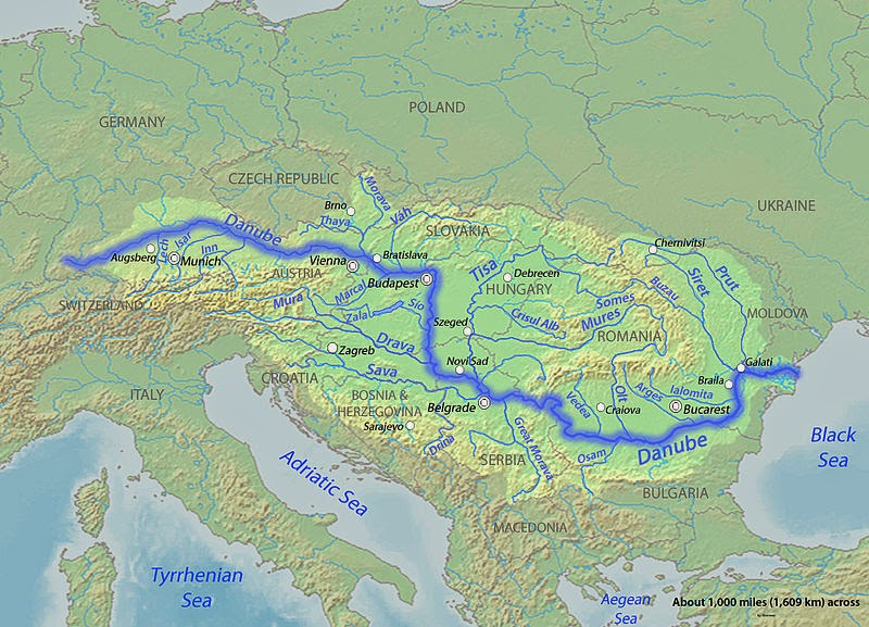
The Danube is a river in Central and Eastern Europe, the European Union’s longest and the continent’s second longest (after the Volga).
Classified as an international waterway, it originates in the town of Donaueschingen—which is in the Black Forest of Germany—at the confluence of the rivers Brigach and Breg. The Danube then flows southeast for 2,872 km (1,785 mi), passing through four capital cities before emptying into the Black Sea via the Danube Delta in Romania and Ukraine.
Once a long-standing frontier of the Roman Empire, the river passes through or touches the borders of ten countries: Romania (29.0% of basin area), Hungary (11.6%), Serbia (10.2%), Austria (10.0%), Germany (7.0%), Bulgaria (5.9%), Slovakia (5.9%), Croatia (4.4%), Ukraine (3.8%), and Moldova (1.6%). Its drainage basin extends into nine more.
Names and etymology
The name Dānuvius is presumably a loan from a Scythian language, or possibly Gaulish. It is one of a number of river names derived from a Proto-Indo-European language word *dānu, apparently a term for “river”, but possibly also of a primeval cosmic river, and of a Vedic river goddess (see Danu), perhaps from a root *dā “to flow/swift, rapid, violent, undisciplined.” Other river names with the same etymology include Don, Donets, Dnieper and Dniestr. Dniepr (pre-Slavic Danapir by Gothic historian Jordanes) and Dniestr, from Danapris and Danastius, are presumed from Scythian Iranian *Dānu apara “river afar” and *Dānu nazdya- “river near”, respectively.
The Danube was known in Latin as Danubius, Danuvius, Ister, in Ancient Greek as Ἴστρος (Istros). The Dacian/Thracian name was Donaris/Donaris (Τάναις in Greek, upper Danube) and Istros (lower Danube). Its Thraco-Phrygian name was Matoas, “the bringer of luck”. The Ancient Greek Istros was a borrowing from Thracian/Dacian meaning “strong, swift”, akin to Sanskrit iṣiras “swift”.
Since the Norman conquest of England, the English language has used the Latin-derived word Danube.
Geology
Although the headwaters of the Danube are relatively small today, geologically, the Danube is much older than the Rhine, with which its catchment area competes in today’s southern Germany. This has a few interesting geological complications. Since the Rhine is the only river rising in the Alps mountains which flows north towards the North Sea, an invisible line beginning at Piz Lunghin divides large parts of southern Germany, which is sometimes referred to as the European Watershed.
Before the last ice age in the Pleistocene, the Rhine started at the southwestern tip of the Black Forest, while the waters from the Alps that today feed the Rhine were carried east by the so-called Urdonau (original Danube). Parts of this ancient river’s bed, which was much larger than today’s Danube, can still be seen in (now waterless) canyons in today’s landscape of the Swabian Alb. After the Upper Rhine valley had been eroded, most waters from the Alps changed their direction and began feeding the Rhine. Today’s upper Danube is but a meek reflection of the ancient one.
The Iron Gate, on the Serbian-Romanian border (Iron Gates natural park and Đerdap national park)
Since the Swabian Alb is largely shaped of porous limestone, and since the Rhine’s level is much lower than the Danube’s, today subsurface rivers carry much water from the Danube to the Rhine. On many days in the summer, when the Danube carries little water, it completely oozes away noisily into these underground channels at two locations in the Swabian Alp, which are referred to as the Donauversickerung (Danube Sink). Most of this water resurfaces only 12 km south at the Aachtopf, Germany’s wellspring with the highest flow, an average of 8500 liters per second, north of Lake Constance—thus feeding the Rhine. The European Water Divide applies only for those waters that pass beyond this point, and only during the days of the year when the Danube carries enough water to survive the sink holes in the Donauversickerung.
Since such large volumes of underground water erode much of the surrounding limestone, it is estimated that the Danube upper course will one day disappear entirely in favor of the Rhine, an event called stream capturing.
The hydrological parameters of Danube are regularly monitored in Croatia at Batina, Dalj, Vukovar and Ilok.
Note : The above story is based on materials provided by Wikipedia


.)