The Indus River is a major river in Asia which flows through Pakistan. It also has courses through western Tibet and Northern India. Originating in the Tibetan Plateau in the vicinity of Lake Mansarovar, the river runs a course through the Ladakh region of Jammu and Kashmir, towards Gilgit and Baltistan and then flows in a southerly direction along the entire length of Pakistan to merge into the Arabian Sea near the port city of Karachi in Sindh. The total length of the river is 3,180 km (1,980 mi). It is Pakistan’s longest river.
The river has a total drainage area exceeding 1,165,000 km2 (450,000 sq mi). Its estimated annual flow stands at around 207 km3 (50 cu mi), making it the twenty-first largest river in the world in terms of annual flow. The Zanskar is its left bank tributary in Ladakh. In the plains, its left bank tributary is the Chenab which itself has four major tributaries, namely, the Jhelum, the Ravi, the Beas and the Sutlej. Its principal right bank tributaries are the Shyok, the Gilgit, the Kabul, the Gomal and the Kurram. Beginning in a mountain spring from Nepal and fed with glaciers and rivers in the Himalayas, the river supports ecosystems of temperate forests, plains and arid countryside.
The Indus forms the delta of present-day Pakistan mentioned in the Vedic Rigveda as Sapta Sindhu and the Iranian Zend Avesta as Hapta Hindu (both terms meaning “seven rivers”). The river has been a source of wonder since the Classical Period, with King Darius of Persia sending Scylax of Caryanda to explore the river as early as 510 BC.
Description
The Indus River provides key water resources for the economy of Pakistan – especially the Breadbasket of Punjab province, which accounts for most of the nation’s agricultural production, and Sindh. The word Punjab means “land of five rivers” and the five rivers are Jhelum, Chenab, Ravi, Beas and Sutlej, all of which finally merge in Indus. The Indus also supports many heavy industries and provides the main supply of potable water in Pakistan.
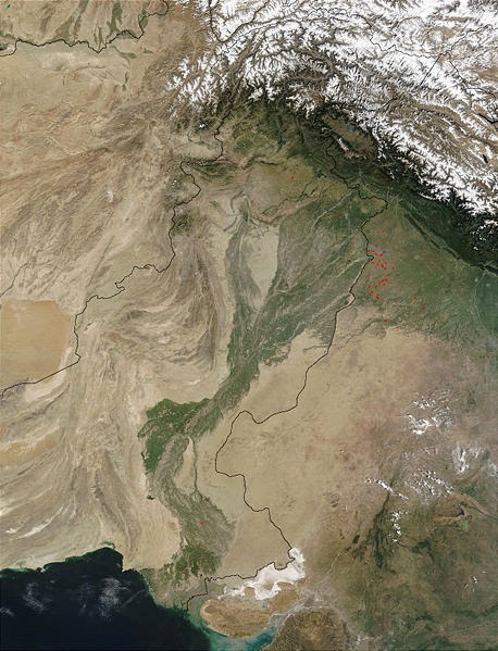
The ultimate source of the Indus is in Tibet; it begins at the confluence of the Sengge and Gar rivers that drain the Nganglong Kangri and Gangdise Shan mountain ranges. The Indus then flows northwest through Ladakh and Baltistan into Gilgit, just south of the Karakoram range. The Shyok, Shigar and Gilgit rivers carry glacial waters into the main river. It gradually bends to the south, coming out of the hills between Peshawar and Rawalpindi. The Indus passes gigantic gorges 4,500–5,200 metres (15,000–17,000 feet) deep near the Nanga Parbat massif. It flows swiftly across Hazara and is dammed at the Tarbela Reservoir. The Kabul River joins it near Attock. The remainder of its route to the sea is in the plains of the Punjab and Sindh, where the flow of the river becomes slow and highly braided. It is joined by the Panjnad at Mithankot. Beyond this confluence, the river, at one time, was named the Satnad River (sat = “seven”, nadī = “river”), as the river was now carrying the waters of the Kabul River, the Indus River and the five Punjab rivers. Passing by Jamshoro, it ends in a large delta to the east of Thatta.
The Indus is one of the few rivers in the world to exhibit a tidal bore. The Indus system is largely fed by the snows and glaciers of the Himalayas, Karakoram and the Hindu Kush ranges of Tibet, the Indian state of Jammu and Kashmir and the Northern Areas of Pakistan respectively. The flow of the river is also determined by the seasons – it diminishes greatly in the winter, while flooding its banks in the monsoon months from July to September. There is also evidence of a steady shift in the course of the river since prehistoric times – it deviated westwards from flowing into the Rann of Kutch and adjoining Banni grasslands after the 1816 earthquake.
The traditional source of the river is the Senge Khabab or “Lion’s Mouth”, a perennial spring, not far from the sacred Mount Kailash, and is marked by a long low line of Tibetan chortens. There are several other tributaries nearby which may possibly form a longer stream than Senge Khabab, but unlike the Senger Khabab, are all dependent on snowmelt. The Zanskar River which flows into the Indus in Ladakh has a greater volume of water than the Indus itself before that point.
“That night in the tent [next to Senge Khabab] I ask Sonmatering which of the Indus tributaries which we crossed this morning is the longest. All of them, he says, start at least a day’s walk away from here. The Bukhar begins near the village of Yagra. The Lamolasay’s source is in a holy place: there is a monastery there. The Dorjungla is a very difficult and long walk, three days perhaps, and there are many sharp rocks; but it its water is clear and blue, hence the tributary’s other name, Zom-chu, which Karma Lama translates as ‘Blue Water’. The Rakmajang rises from a dark lake called the Black Sea.
One of the longest tributaries — and thus a candidate for the river’s technical source — is the Kla-chu, the river we crossed yesterday by bridge. Also known as the Lungdep Chu, it flows into the Indus from the south-east, and rises a day’s walk from Darchen. But Sonamtering insists that the Dorjungla is the longest of the ‘three types of water’ that fall into the Seng Tsanplo [‘Lion River’ or Indus].”
Geography
Tributaries
- Nagar River
- Astor River
- Balram River
- Dras River
- Gar River
- Ghizar River
- Gilgit River
- Gomal River
- Kabul River
- Kurram River
- Panjnad River
- Shigar River
- Shyok River
- Soan River
- Tanubal River
- Zanskar River
- Jhelum River
- Ravi River
- Chenab River
- Beas River
- Satluj River
Geology
The Indus river feeds the Indus submarine fan, which is the second largest sediment body on the Earth at around 5 million cubic kilometres of material eroded from the mountains. Studies of the sediment in the modern river indicate that the Karakoram Mountains in northern Pakistan and India are the single most important source of material, with the Himalayas providing the next largest contribution, mostly via the large rivers of the Punjab (Jhelum, Ravi, Chenab, Beas and Sutlej). Analysis of sediments from the Arabian Sea has demonstrated that prior to five million years ago the Indus was not connected to these Punjab rivers which instead flowed east into the Ganges and were captured after that time. Earlier work showed that sand and silt from western Tibet was reaching the Arabian Sea by 45 million years ago, implying the existence of an ancient Indus River by that time. The delta of this proto-Indus river has subsequently been found in the Katawaz Basin, on the Afghan-Pakistan border.
In the Nanga Parbat region, the massive amounts of erosion due to the Indus river following the capture and rerouting through that area is thought to bring middle and lower crustal rocks to the surface.
Note : The above story is based on materials provided by Wikipedia


