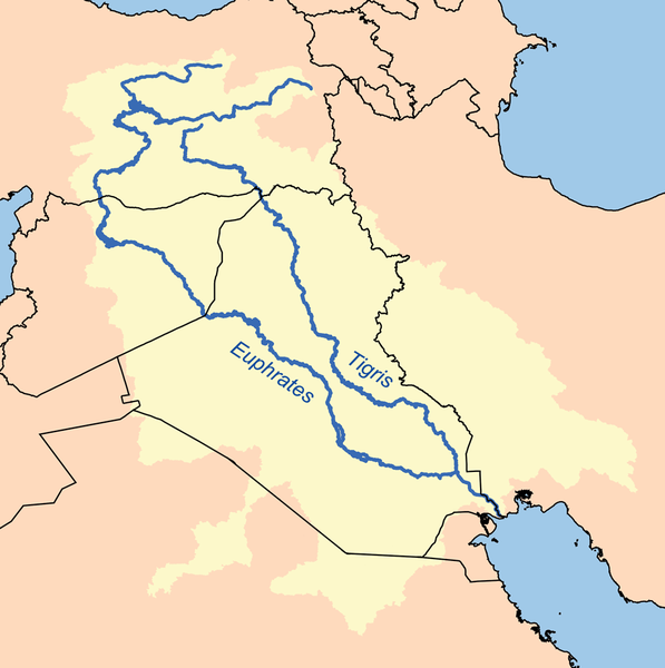
The Euphrates is the longest and one of the most historically important rivers of Western Asia. Together with the Tigris, it is one of the two defining rivers of Mesopotamia. Originating in eastern Turkey, the Euphrates flows through Syria and Iraq to join the Tigris in the Shatt al-Arab, which empties into the Persian Gulf.
Etymology
The Ancient Greek form Euphrátēs (Ancient Greek: Εὐφράτης) was borrowed from Old Persian Ufrātu, itself from Elamite ú-ip-ra-tu-iš. In Akkadian the river was similarly called Purattu, which has been perpetuated in Semitic languages (cf. Syriac P(ə)rāṯ, Arabic al-Furrāt) and in other nearby languages of the time (cf. Hurrian Puranti, Sabarian Uruttu). The Elamite, Akkadian, and possibly Sumerian forms are from an unrecorded substrate language.
The earliest references to the Euphrates come from cuneiform texts found in Shuruppak and pre-Sargonic Nippur in southern Iraq and date to the mid-3rd millennium BCE. In these texts, written in Sumerian, the Euphrates is called Buranuna (logographic: UD.KIB.NUN). The name could also be written KIB.NUN.(NA) or dKIB.NUN, with the prefix “d” indicating that the river was a divinity. In Sumerian, the name of the city of Sippar in modern-day Iraq was also a written UD.KIB.NUN, indicating a historically strong relationship between the city and the river.
Course
The Euphrates is the longest river of Western Asia. It emerges from the confluence of the Kara Su or Western Euphrates (450 kilometres (280 mi)) and the Murat Su or Eastern Euphrates (650 kilometres (400 mi)) 10 kilometres (6.2 mi) upstream from the town of Keban in southeastern Turkey.Daoudy and Frenken put the length of the Euphrates from the source of the Murat River to the confluence with the Tigris at 3,000 kilometres (1,900 mi), of which 1,230 kilometres (760 mi) falls in Turkey, 710 kilometres (440 mi) in Syria and 1,060 kilometres (660 mi) in Iraq. The same figures are given by Isaev and Mikhailova. The length of the Shatt al-Arab, which connects the Euphrates and the Tigris with the Persian Gulf, is given by various sources as 145–195 kilometres (90–121 mi).
Both the Kara Su and the Murat Su rise northwest from Lake Van at elevations of 3,290 metres (10,790 ft) and 3,520 metres (11,550 ft) amsl, respectively. At the location of the Keban Dam, the two rivers, now combined into the Euphrates, have dropped to an elevation of 693 metres (2,274 ft) amsl. From Keban to the Syrian–Turkish border, the river drops another 368 metres (1,207 ft) over a distance of less than 600 kilometres (370 mi). Once the Euphrates enters the Upper Mesopotamian plains, its grade drops significantly; within Syria the river falls 163 metres (535 ft) while over the last stretch between Hīt and the Shatt al-Arab the river drops only 55 metres (180 ft).
Discharge of the Euphrates
The Euphrates receives most of its water in the form of rainfall and melting snow, resulting in peak volumes during the months April through May. Discharge in these two months accounts for 36 percent of the total annual discharge of the Euphrates, or even 60–70 percent according to one source, while low runoff occurs in summer and autumn. The average natural annual flow of the Euphrates has been determined from early- and mid-twentieth century records as 20.9 cubic kilometres (5.0 cu mi) at Keban, 36.6 cubic kilometres (8.8 cu mi) at Hīt and 21.5 cubic kilometres (5.2 cu mi) at Hindiya. However, these averages mask the high inter-annual variability in discharge; at Birecik, just above the Syro–Turkish border, annual discharges have been measured that ranged from a low volume of 15.3 cubic kilometres (3.7 cu mi) in 1961 to a high 42.7 cubic kilometres (10.2 cu mi) in 1963.
The discharge regime of the Euphrates has changed dramatically since the construction of the first dams in the 1970s. Data on Euphrates discharge collected after 1990 show the impact of the construction of the numerous dams in the Euphrates and of the increased withdrawal of water for irrigation. Average discharge at Hīt after 1990 has dropped to 356 cubic metres (12,600 cu ft) per second (11.2 cubic kilometres (2.7 cu mi) per year). The seasonal variability has equally changed. The pre-1990 peak volume recorded at Hīt was 7,510 cubic metres (265,000 cu ft) per second, while after 1990 it is only 2,514 cubic metres (88,800 cu ft) per second. The minimum volume at Hīt remained relatively unchanged, rising from 55 cubic metres (1,900 cu ft) per second before 1990 to 58 cubic metres (2,000 cu ft) per second afterward.
Tributaries
In Syria, three rivers add their water to the Euphrates; the Sajur, the Balikh and the Khabur. These rivers rise in the foothills of the Taurus Mountains along the Syro–Turkish border and add comparatively little water to the Euphrates. The Sajur is the smallest of these tributaries; emerging from two streams near Gaziantep and draining the plain around Manbij before emptying into the reservoir of the Tishrin Dam. The Balikh receives most of its water from a karstic spring near ‘Ayn al-‘Arus and flows due south until it reaches the Euphrates at the city of Ar-Raqqah. In terms of length, drainage basin and discharge, the Khabur is the largest of these three. Its main karstic springs are located around Ra’s al-‘Ayn, from where the Khabur flows southeast past Al-Hasakah, where the river turns south and drains into the Euphrates near Busayrah. Once the Euphrates enters Iraq, there are no more natural tributaries to the Euphrates, although canals connecting the Euphrates basin with the Tigris basin exist.
Watershed
The drainage basins of the Kara Su and the Murat River cover an area of 22,000 square kilometres (8,500 sq mi) and 40,000 square kilometres (15,000 sq mi), respectively. The estimates that have been made for the area of the Euphrates drainage basin vary widely; from a low 233,000 square kilometres (90,000 sq mi) to a high 766,000 square kilometres (296,000 sq mi). Recent estimates put the basin area at 388,000 square kilometres (150,000 sq mi), 444,000 square kilometres (171,000 sq mi) and 579,314 square kilometres (223,674 sq mi). The greater part of the Euphrates basin is located in Turkey, Syria and Iraq. According to both Daoudy and Frenken, Turkey’s share is 28 percent, Syria’s is 17 percent and that of Iraq is 40 percent. Isaev and Mikhailova estimate the percentages of the drainage basin lying within Turkey, Syria and Iraq at 33, 20 and 47 percent respectively. Some sources estimate that approximately 15 percent of the drainage basin is located within Saudi Arabia, while a small part falls inside the borders of Kuwait. Finally, some sources also include Jordan in the drainage basin of the Euphrates; a small part of the eastern desert (220 square kilometres (85 sq mi)) drains toward the east rather than to the west.
Note : The above story is based on materials provided by Wikipedia


