Is one of the world’s great cities due to be struck by a serious earthquake? Ekbal Hussain describes how scientists are working to make sure Istanbul is prepared for the dangers that may be on the way.
Straddling the European and Asian borders Istanbul is an ancient and beautiful city. Once known as Constantinople, it has been at the centre of major empires including the Roman, Byzantine, Latin and Ottoman. This great city is inundated with rich culture and history, and with nearly 14 million inhabitants it is also one of the largest cities in the world.
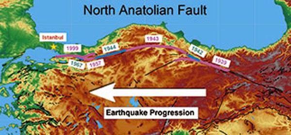
But this thriving metropolis sits on the edge of one of the fastest moving faults in the world: the North Anatolian Fault. This is a system of large fractures within the Earth on which energy, from the motion of the tectonic plates, is stored and released in earthquakes.
The North Anatolian Fault is roughly 1300km long, running along the entire length of northern Turkey from the Aegean Sea in the west to Lake Van in the east. It slips such that central and southern Turkey are moving west relative to northern Turkey at speeds of 20-30mm a year. It is the most active and destructive earthquake-prone fault system in Turkey.
It has been known for a while now that earthquakes on the fault tend to follow a regular sequence. That is, an earthquake will often occur on the section of the fault adjacent to the last rupture. Starting with the 1939 magnitude 7.9 Erzincan earthquake and culminating in the 1999 magnitude 7.4 and 7.2 earthquakes, there have been 12 events with magnitudes greater than 6.4 that together have ruptured almost the entire length of the fault.
The map shows this westward progression of seismic activity. The 1999 Izmit (magnitude 7.4) and Duzce (magnitude 7.2) earthquakes killed about 18,000 people, mostly in the city of Izmit. These events occurred less than 100km east of Istanbul, leading some researchers to predict the next quake will strike Istanbul itself.
Seismologists calculate the chance of an earthquake greater than magnitude 7 occurring near Istanbul in the next 30 years at somewhere between 35 and 70 per cent. And with almost a million people moving to the metropolis every year it is no surprise that Istanbul is a major candidate for the so called ‘million-death quake.’
We need to improve our ability to forecast such quakes by creating realistic models of the fault’s behaviour, and to do this we need to know more about the fault itself.
The NERC-funded FaultLab project based at the University of Leeds is helping address these problems, with support from the University’s Climate and Geohazard Services group. The investigators use data from a multitude of sources including satellite radar and geological observations, as well as data from the densest network of seismic stations ever deployed across a fault.
The project scientists aim to use the seismic data to investigate the deep structure of the fault and to see if there are differences in the crust either side of the fracture. The geologists will be looking at an old fault zone to probe the microscopic structure of minerals inside these large fracture zones. Together, these observations will enable us to better understand what the fault is doing deep in the ground and how this has affected the crust adjacent to it. The geodesy group (earth observation scientists) will use satellite radar to make accurate maps of how the ground surface is moving and relate that to the amount of energy being stored on the fault. Finally, the modelling team will link these observations together to produce an accurate picture of the behaviour of the fault. These results can then feed into models to make a more realistic forecast of the hazard Istanbul faces.
A resilient city
Professor Nicholas Ambraseys, a leading expert in the field, famously said: ‘Earthquakes don’t kill people, buildings do.’
We technically don’t need to know when the earthquake will occur to save lives. Death and injury can be prevented through simple engineering works to reinforce vulnerable buildings and by ensuring new structures are built to earthquake-resilient standards. It’s estimated to cost only 10 per cent more to build a house that is earthquake resistant compared to one that isn’t.
The Turkish government has not been idle. The new Sabiha Gökçen International Airport terminal, which opened in October 2009, is designed to withstand shaking from a magnitude 8 earthquake and, importantly, keep working afterwards – this will be an important entry point for foreign aid after a disaster.
The Marmaray rail tunnel, opened in October 2013, runs beneath the Bosphorus Straits and links the European and Asian sides of the country. The rail tunnel was built to withstand a magnitude 9 earthquake.
In May 2012 a new Urban Transformation Law was passed, stating that all buildings that do not meet current earthquake hazard criteria will be demolished. This means nearly 6.5 million buildings throughout Turkey could be demolished over the next two decades, and will pave the way for more resilient cities.
Ambitions on this scale need strong governance and management, but they also need good science – to help the Turkish government prioritise its engineering projects and work on effective evacuation and mitigation plans. The results from the FaultLab project will help develop and refine their forecast models, so those plans can be put in action the moment there’s a sign that a deadly earthquake is imminent.
Note : The above story is based on materials provided by Ekbal Hussain is a PhD student in the School of Earth and Environment at the University of Leeds. ” © Natural Environment Research Council “


