The Yellow River or Huang He is the second-longest river in Asia, following the Yangtze River, and the sixth-longest in the world at the estimated length of 5,464 km (3,395 mi). Originating in the Bayan Har Mountains in Qinghai province of western China, it flows through nine provinces, and it empties into the Bohai Sea near the city of Dongying in Shandong province. The Yellow River basin has an east–west extent of about 1,900 kilometers (1,180 mi) and a north–south extent of about 1,100 km (680 mi). Its total basin area is about 742,443 square kilometers (286,659 sq mi).
The Yellow River is called “the cradle of Chinese civilization”, because its basin was the birthplace of ancient Chinese civilization, and it was the most prosperous region in early Chinese history. However, frequent devastating floods and course changes produced by the continual elevation of the river bed, sometimes above the level of its surrounding farm fields, has also earned it the unenviable names China’s Sorrow and Scourge of the Sons of Han.
Name
Early Chinese literature including the Yu Gong or Tribute of Yu dating to the Warring States period (475 – 221 BC) refers to the Yellow River as simply 河 (Old Chinese: *C.gˤaj), a character that has come to mean “river” in modern usage. The first appearance of the name 黃河 (Old Chinese: *N-kʷˤaŋ C.gˤaj; Middle Chinese: Hwang Ha) is in the Book of Han written during the Western Han dynasty (206 BC – AD 9). The adjective “yellow” describes the perennial color of the muddy water in the lower course of the river, which arises from soil (loess) being carried downstream.
One of its older Mongolian names was the “Black River”, because the river runs clear before it enters the Loess Plateau, but the current name of the river among Inner Mongolians is Ȟatan Gol (Хатан гол, “Queen River”). In Mongolia itself, it is simply called the Šar Mörön (Шар мөрөн, “Yellow River”).
In Qinghai, the river’s Tibetan name is “River of the Peacock” (Tibetan: རྨ་ཆུ།, Ma Chu; Chinese: s 玛曲, t 瑪曲, p Mǎ Qū).
The name Hwang Ho in English is the Postal Map romanization of the river’s Mandarin name.
Geography
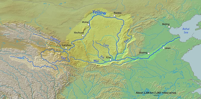
According to the China Exploration and Research Society, the source of the Yellow River is at 34° 29′ 31.1″ N, 96° 20′ 24.6″ E in the Bayan Har Mountains near the eastern edge of the Yushu Tibetan Autonomous Prefecture. The source tributuaries drain into Gyaring Lake and Ngoring Lake on the western edge of Golog Prefecture high in the Bayan Har Mountains of Qinghai. In the Zoige Basin along the boundary with Gansu, the Yellow River loops northwest and then northeast before turning south, creating the “Ordos Loop”, and then flows generally eastward across the North China Plain to the Gulf of Bohai, draining a basin of 752,443 square kilometers (290,520 sq mi) which nourishes 140 million people with drinking water and irrigation.
The Yellow River passes through seven present-day provinces and two autonomous regions, namely (from west to east) Qinghai, Gansu, Ningxia, Inner Mongolia, Shaanxi, Shanxi, Henan, and Shandong. Major cities along the present course of the Yellow River include (from west to east) Lanzhou, Yinchuan, Wuhai, Baotou, Luoyang, Zhengzhou, Kaifeng, and Jinan. The current mouth of the Yellow River is located at Kenli County, Shandong.
The river is commonly divided into three stages. These are roughly the northeast of the Tibetan Plateau, the Ordos Loop and the North China Plain. However, different scholars have different opinions on how the three stages are divided.[citation needed] This article adopts the division used by the Yellow River Conservancy Commission.
Note : The above story is based on materials provided by Wikipedia


