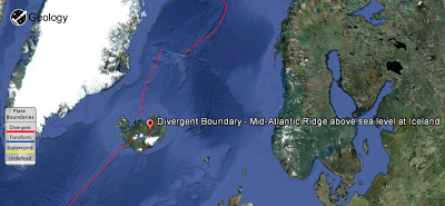
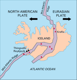
Mid-Atlantic Ridge above sea level at Iceland A geologically young land, Iceland is located on both the Iceland hotspot and the Mid-Atlantic Ridge, which runs right through it. This location means that the island is highly geologically active with many volcanoes, notably Hekla, Eldgjá, Herðubreið and Eldfell.
Iceland has many geysers, including Geysir, from which the English word is derived, and the famous Strokkur, which erupts every 5–10 minutes. After a phase of inactivity, Geysir started erupting again after a series of earthquakes in 2000. Geysir has since then grown quieter and does not erupt often.
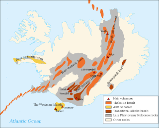
With the widespread availability of geothermal power, and the harnessing of many rivers and waterfalls for hydroelectricity, most residents have access to inexpensive hot water, heating and electricity. The island itself is composed primarily of basalt, a low-silica lava associated with effusive volcanism as has occurred also in Hawaii. Iceland, however, has a variety of volcanic types (composite and fissure), many producing more evolved lavas such as rhyolite and andesite. Iceland has hundreds of volcanoes within approx. 30 volcanic systems active
Surtsey, one of the youngest islands in the world, is part of Iceland. Named after Surtr, it rose above the ocean in a series of volcanic eruptions between 8 November 1963 and 5 June 1968. Only scientists researching the growth of new life are allowed to visit the island.
On 21 March 2010, a volcano in Eyjafjallajökull in the south of Iceland erupted for the first time since 1821, forcing 600 people to flee their homes. Further eruptions on 14 April forced hundreds of people to abandon their homes. The resultant cloud of volcanic ash brought major disruption to air travel across Europe.
Another large eruption occurred on 21 May 2011. This time it was the Grímsvötn volcano, located under the thick ice of Europe’s largest glacier, Vatnajökull. Grímsvötn is one of Iceland’s most active volcanoes and this eruption was much more powerful than the 2010 Eyjafjallajökull activity. The eruption hurled ash and lava 20 km (12.43 mi) up into the atmosphere, creating a large cloud that for a while was thought to pose a danger to jet aircraft over a wide area of northern Europe.
Volcanology of Iceland


