Tectonic explanation of what happened
Turkey is a tectonically active country that experiences frequent destructive earthquakes. On a broad scale, the seismtectonics of the region near the October 23, 2011 earthquake are controlled by the collision of the Arabian Plate and Eurasian plates; at the latitude of this event, the Arabian plate converges with Eurasia in a northerly direction at a rate of approximately 24 mm/yr. West of the October 23, 2011, earthquake tectonics are dominated by strike-slip faulting on the East (in southern Turkey) and North (in northern Turkey) Anatolian fault zones. These large, translational fault systems extend across much of central and western Turkey and accommodate the western motion of the Anatolian block as it is being squeezed by the converging Arabian and Eurasian plates.
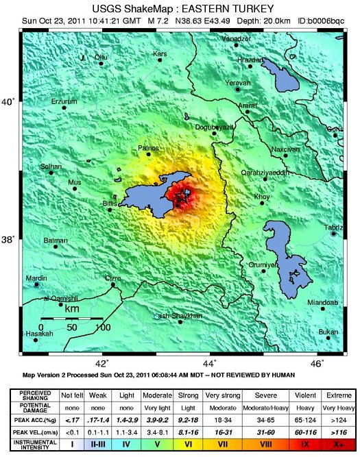
In the area of Lake Van and further east, tectonics are dominated by the Bitlis Suture Zone (in eastern Turkey) and Zagros fold and thrust belt (toward Iran). The October 23, 2011 earthquake occurred in a broad region of convergence beyond the eastern extent of Anatolian strike-slip tectonics. The focal mechanism of today’s earthquake is consistent with oblique-thrust faulting similar to mapped faults in the region.
This earthquake is a reminder of the many deadly seismic events that Turkey has suffered in the recent past. The devastating Izmit earthquake of 1999 (M = 7.6) broke a section of the North Anatolian Fault 1000 km to the west of the October 23 event and killed 17,000 people, injured 50,000, and left 500,000 homeless. Approximately 70 km from this earthquake a M7.3 earthquake occurred on November 11, 1976 destroying several villages near the Turkey and Iran border and killing several thousand people.
A M7.8 earthquake struck Erzincan in 1939, killing an estimated 33,000 people.
A M7.8 earthquake struck Erzincan in 1939, killing an estimated 33,000 people.
Text and images courtesy USGS
copied from earthquake Reports


