The ground east of the Rockies is far more likely to shake this year with damaging though not deadly earthquakes, federal seismologists report in a new risk map for 2016. Much of that is a man-made byproduct of drilling for energy.
Parts of Oklahoma now match northern California for the nation’s most shake prone. One north-central Oklahoma region has a 1 in 8 chance of a damaging quake in 2016, with other parts closer to 1 in 20.
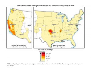
Overall, 7 million people live in areas where the risk has dramatically jumped for earthquakes caused by disposal of wastewater, a byproduct of drilling for oil and gas. That is mostly concentrated in Oklahoma, Texas, New Mexico, Kansas, Colorado and Arkansas.
Natural earthquake risk also increased around the New Madrid fault in Missouri, Tennessee, Kentucky, Arkansas and Illinois.
In a first-of-its-kind effort, the U.S. Geological Survey on Monday released a map for risks of damaging quakes in the current year. Past efforts looked at 50-year risks and didn’t include man-made quakes. The new risks are mostly based on increases in quakes felt last year.
These are not massive quakes that kill hundreds or thousands of people and leave devastation in their wake. Instead, these smaller quakes happen more frequently, said Mark Petersen, chief of the National Seismic Hazard Mapping Project. They damage but don’t topple buildings.
“There’s no question that there’s a lot of shaking going on in Oklahoma, Kansas and Texas,” Petersen said in an interview after a press conference Monday. “These are much higher ground motions” than the last time he created the longer-term map, in 2014.
For example, on that map the risk was low in Dallas; now, after a tenfold increase in risk, Petersen said it compares to places in California. The Dallas-Fort Worth area risk is between 2 to 5 percent this year, he said.
“Oklahoma and Texas have the largest population exposed to induced quakes,” Petersen said.
North-central Oklahoma was said to have a 12 percent risk, and it has already been hit: A 5.1 magnitude quake caused some damage around Fairview in February.
Seismologist Rowena Lohman of Cornell University, who wasn’t part of the map team, said the increase around Oklahoma is easily noticeable and scientists are trying to determine whether these man-made smaller quakes lead to larger events.
Induced quakes are to blame for much of the problem. They result when wastewater is injected deep underground, said USGS seismologist Justin Rubinstein, the deputy chief of the mapping program. That injection is a byproduct of energy drilling, including hydraulic fracturing, a relatively new and controversial process to drill for oil and gas. But he said the fracking process itself mostly doesn’t cause quakes strong enough to be damaging, while injecting fracking waste does.
Rubinstein said there is a scientific consensus “that wastewater disposal does cause earthquakes.”
Arkansas, Kansas and Ohio saw dramatic reductions in man-made quakes when those states tighten restrictions on wastewater injections, Rubinstein said.
In Oklahoma, “the longer we go, the more we pump down there, the more likelihood we have that we’re going to have larger quakes,” Petersen said.
Oklahoma Gov. Mary Fallin said the research justifies action taken by Oklahoma earlier this year to cut back on injections.
“Recent declines in produced wastewater disposal in Oklahoma are not reflected in the USGS map,” Fallin said. “This gives us even a stronger base in going forward and gives state regulators further justification for what they are doing.”
Rubinstein said it’s too early to see any results from Oklahoma’s new efforts.
The increase in the natural quakes in the New Madrid area remains a mystery, Petersen said, but “it’s higher than it’s been in several years.”
Reference:
USGS One-year seismic map: pubs.usgs.gov/of/2016/1035/ofr20161035.pdf
Note: The above post is reprinted from materials provided by The Associated Press.


