Padma is a major river in Bangladesh. It is the main distributary of the Ganges, flowing generally southeast for 120 kilometres (75 mi) to its confluence with the Meghna River near the Bay of Bengal. The city of Rajshahi is situated on the banks of the river.
History
Etymology
The Padma, Sanskrit for lotus flower, is mentioned in Hindu mythology as a byname for the Goddess Lakshmi.
The name Padma is given to the lower part of the course of the Ganges (Ganga) below the point of the off-take of the Bhagirathi River (India), another Ganges River distributary also known as the Hooghly River. Padma had, most probably, flowed through a number of channels at different times. Some authors contend that each distributary of the Ganges in its deltaic part is a remnant of an old principal channel, and that starting from the western-most one, the Bhagirathi (in West Bengal, India), each distributary to the east marks a position of a newer channel than the one to the west of it.
Geographic effects
Eighteenth-century geographer James Rennell referred to a former course of the Ganges north of its present channel, as follows:
- Appearances favour very strongly that the Ganges had its former bed in the tract now occupied by the lakes and morasses between Natore and Jaffiergunge, striking out of the present course by Bauleah to a junction of Burrrampooter or Megna near Fringybazar, where accumulation of two such mighty streams probably scooped out the present amazing bed of the Megna.
The places mentioned by Rennell proceeding from west to east are Rampur Boali, the headquarters of Rajshahi district, Puthia and Natore in the same district and Jaffarganj in the district of Dhaka. The place last named were shown in a map of the Mymensingh district dated 1861, as a subdistrict (thana) headquarters, about 10 kilometres (6 mi) south-east of Bera Upazila police station. It is now known as Payla Jaffarganj and is close to Elachipur opposite Goalunda. According to Rennell’s theory, therefore, the probable former course of the Ganges would correspond with that of the present channel of the Baral River.
Authorities agree that the Ganges has changed its course and that at different times, each of the distributaries might have been the carrier of its main stream.
The bed of the Padma is wide, and the river is split up into several channels flowing between constantly shifting sand banks and islands. During the rains the current is very strong and even steamers may find difficulty in making headway against it. It is navigable at all seasons of the year by steamers and country boats of all sizes and until recently ranked as one of the most frequented waterways in the world. It is spanned near Paksey by the great Hardinge Bridge over which runs one of the main lines of the Bangladesh Railway.
Geography
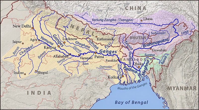
The Padma enters Bangladesh from India near Chapai Nababganj and meets the Jamuna (Bengali: যমুনা Jomuna) near Aricha and retains its name, but finally meets with the Meghna (Bengali: মেঘনা) near Chandpur and adopts the name “Meghna” before flowing into the Bay of Bengal.
Rajshahi, a major city in western Bangladesh, is situated on the north bank of the Padma.
The Ganges originates in the Gangotri Glacier of the Himalaya, and runs through India and Bangladesh to the Bay of Bengal. The Ganges enters Bangladesh at Shibganj in the district of Chapai Nababganj. West of Shibganj, the Ganges branches into two distributaries, the Bhagirathi and the Padma rivers. The Bhagirathi River, which flows southwards, is also known as the Ganga and was named the Hoogly or Hooghly by the British.
Further downstream, in Goalando, 2,200 kilometres (1,400 mi) from the source, the Padma is joined by the Jamuna (Lower Brahmaputra) and the resulting combination flows with the name Padma further east, to Chandpur. Here, the widest river in Bangladesh, the Meghna joins the Padma, continuing as the Meghna almost in a straight line to the south, ending in the Bay of Bengal.
Pabna District
The Padma forms the whole of the southern boundary of the Pabna District for a distance of about 120 kilometres (75 mi).
Kushtia District
The Jalangi River is thrown off at the point where the mighty Padma touches the district at its most northernly corner, and flows along the northern border in a direction slightly southeast, until it leaves the district some miles to the east of Kushtia. It carries immense volumes of water and is very wide at places, constantly shifting its main channel, eroding vast areas on one bank, throwing chars on the other, giving rise to many disputes as to the possession of the chars and islands which are thrown up.
Note : The above story is based on materials provided by Wikipedia.


 to its co)