The Mekong is a trans-boundary river in Southeast Asia. It is the world’s 12th-longest river and the 7th-longest in Asia. Its estimated length is 4,350 km (2,703 mi), and it drains an area of 795,000 km2 (307,000 sq mi), discharging 457 km3 (110 cu mi) of water annually.
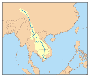
From the Tibetan Plateau this river runs through China’s Yunnan province, Burma (Myanmar), Laos, Thailand, Cambodia and Vietnam. In 1995, Laos, Thailand, Cambodia and Vietnam established the Mekong River Commission to assist in the management and coordinated use of the Mekong’s resources. In 1996 China and Burma (Myanmar) became “dialogue partners” of the MRC and the six countries now work together within a cooperative framework.
The extreme seasonal variations in flow and the presence of rapids and waterfalls in this river have made navigation difficult. The river is a major trading route linking China’s southwestern province of Yunnan to Laos, Burma (Myanmar) and Thailand to the south, an important trade route between western China and Southeast Asia.
Course
The Mekong rises as the Lancang (Lantsang) in the “Three Rivers Area” on the Tibetan Plateau in the Sanjiangyuan National Nature Reserve; the reserve protects the headwaters of, from north to south, the Yellow (Huang He), the Yangtze and the Mekong Rivers. It flows southeast through Yunnan Province, and then through the Three Parallel Rivers Area in the Hengduan Mountains, along with the Yangtze to its north and the Salween River (Nujiang in Chinese) to its south.
The Mekong then meets the tripoint of China, Burma (Myanmar) and Laos. From there it flows southwest and forms the border of Burma and Laos for about 100 kilometres (62 mi) until it arrives at the tripoint of Burma, Laos, and Thailand. This is also the point of confluence between the Ruak River (which follows the Thai-Burma border) and the Mekong. The area of this tripoint is sometimes termed the Golden Triangle, although the term also refers to the much larger area of those three countries that is notorious as a drug producing region.
From the Golden Triangle tripoint, the Mekong turns southeast to briefly form the border of Laos with Thailand. It then turns east into the interior of Laos, flowing first east and then south for some 400 kilometres (250 mi) before meeting the border with Thailand again. Once more, it defines the Laos-Thailand border for some 850 kilometres (530 mi) as it flows first east, passing in front of the capital of Laos, Vientiane, then turns south. A second time, the river leaves the border and flows east into Laos soon passing the city of Pakse. Thereafter, it turns and runs more or less directly south, crossing into Cambodia.
At Phnom Penh the river is joined on the right bank by the river and lake system the Tonlé Sap. When the Mekong is low, the Tonle Sap is a tributary; water flows from the lake and river into the Mekong. When the Mekong floods, the flow reverses; the floodwaters of the Mekong flow up the Tonle Sap.
Immediately after the Sap River joins the Mekong by Phnom Penh, the Bassac River branches off the right (west) bank. The Bassac River is the first and main distributary of the Mekong; thus, this is the beginning of the Mekong Delta. The two rivers, the Bassac to the west and the Mekong to the east, enter Vietnam very soon after this. In Vietnam, the Bassac is called the Hậu River (Sông Hậu or Hậu Giang); the main, eastern, branch of the Mekong is called the Tiền River or Tiền Giang. In Vietnam, distributaries of the eastern (main, Mekong) branch include the Mỹ Tho River, the Ba Lai River, the Hàm Luông River, and the Cổ Chiên River.
Drainage basin
The Mekong Basin can be divided into two parts: the ‘Upper Mekong Basin’ in Tibet and China, and the ‘Lower Mekong Basin’ from Yunnan downstream from China to the South China Sea. From the point where it rises to its mouth, the most precipitous drop in the Mekong occurs in Upper Mekong Basin, a stretch of some 2,200 km (1,400 mi). Here, it drops 4,500 metres (14,800 ft) before it enters the Lower Basin where the borders of Thailand, Laos, China and Burma (Myanmar) come together in the Golden Triangle. Downstream from the Golden Triangle, the river flows for a further 2,600 km (1,600 mi) through Laos, Thailand and Cambodia before entering the South China Sea via a complex delta system in Vietnam.
Upper Mekong Basin
The Upper Basin makes up 24% of the total area and contributes 15 to 20% of the water that flows into the Mekong River. The catchment here is steep and narrow. Soil erosion has been a major problem and approximately 50% of the sediment in the river comes from the Upper Basin.
In Yunnan province in China, the river and its tributaries are confined by narrow, deep gorges. The tributary river systems in this part of the basin are small. Only 14 have catchment areas that exceed 1,000 km2 (390 sq mi), yet the greatest amount of loss of forest cover in the entire river system per square kilometer has occurred in this region due to heavy unchecked demand for natural resources. In the south of Yunnan, in Simao and Xishuangbanna Prefectures, the river changes as the valley opens out, the floodplain becomes wider, and the river becomes wider and slower.
Lower Mekong Basin
Major tributary systems develop in the Lower Basin. These systems can be separated into two groups: tributaries that contribute to the major wet season flows, and tributaries that drain low relief regions of lower rainfall. The first group are left bank tributaries that drain the high-rainfall areas of Lao PDR. The second group are those on the right bank, mainly the Mun and Chi rivers, that drain a large part of Northeast Thailand.
Laos lies almost entirely within the Lower Mekong Basin. Its climate, landscape and land use are the major factors shaping the hydrology of the river. The mountainous landscape means that only 16% of the country is farmed under lowland terrace or upland shifting cultivation. With upland shifting agriculture (slash and burn), soils recover within 10 to 20 years but the vegetation does not. Shifting cultivation is common in the uplands of Northern Laos and is reported to account for as much as 27% of the total land under rice cultivation. As elsewhere in the basin, forest cover has been steadily reduced during the last three decades by shifting agriculture and permanent agriculture. The cumulative impacts of these activities on the river regime have not been measured. However, the hydrological impacts of land-cover changes induced by the Vietnam War were quantified in two sub-catchments of the Lower Mekong River Basin.
Loss of forest cover in the Thai areas of the Lower Basin has been the highest in all the Lower Mekong countries over the past 60 years. On the Korat Plateau, which includes the Mun and Chi tributary systems, forest cover was reduced from 42% in 1961 to 13% in 1993. Although this part of Northeast Thailand has an annual rainfall of more than 1,000 mm, a high evaporation rate means it is classified as a semi arid region. Consequently, although the Mun and Chi Basins drain 15% of the entire Mekong Basin, they only contribute 6% of the average annual flow. Sandy and saline soils are the most common soil types, which makes much of the land unsuitable for wet rice cultivation. In spite of poor fertility, however, agriculture is intensive. Glutinous rice, maize and cassava are the principal crops. Drought is by far the major hydrological hazard in this region.
As the Mekong enters Cambodia, over 95% of the flows have already joined the river. From here on downstream the terrain is flat and water levels rather than flow volumes determine the movement of water across the landscape. The seasonal cycle of changing water levels at Phnom Penh results in the unique “flow reversal” of water into and out of the Great Lake via the Tonle Sap River. Phnom Penh also marks the beginning of the delta system of the Mekong River. Here the mainstream begins to break up into an increasing number of branches.
In Cambodia, the wet rice is the main crop and is grown on the flood plains of the Tonle Sap, Mekong and Bassac (the Mekong delta distributary known as the Hậu in Vietnam) rivers. More than half of Cambodia remains covered with mixed evergreen and deciduous broadleaf forest, but forest cover has decreased from 73% in 1973 to 63% in 1993. Here, the river landscape is flat. Small changes in water level determine the direction of water movement, including the large-scale reversal of flow into and out of the Tonle Sap basin from the Mekong River.
The Mekong Delta in Viet Nam is farmed intensively and has little natural vegetation left. Forest cover is less than 10%. In the Central Highlands of Vietnam, forest cover was reduced from over 95% in the 1950s to around 50% in the mid 1990s. Agricultural expansion and population pressure are the major reasons for land use and landscape change. Both drought and flood are common hazards in the Delta, which many people believe is the most sensitive to upstream hydrological change.
Geology
The internal drainage patterns of the Mekong are unusual when compared to those of other large rivers. Most large river systems that drain the interiors of continents, such as the Amazon, Congo, and Mississippi, have relatively simple dendritic tributary networks that resemble a branching tree.
Typically, such patterns develop in basins with gentle slopes where the underlying geological structure is fairly homogenous and stable, exerting little or no control on river morphology. In marked contrast, the tributary networks of the Salween, Yangtze, and particularly the Mekong, are complex with different sub-basins often exhibiting different, and distinct, drainage patterns. These complex drainage systems have developed in a setting where the underlying geological structure is heterogeneous and active, and is the major factor controlling the course of rivers and the landscapes they carve out.
The elevation of the Tibetan Plateau during the Tertiary period was an important factor in the genesis of the south-west monsoon, which is the dominant climatic control influencing the hydrology of the Mekong Basin. Understanding the nature and timing of the elevation of Tibet (and the Central Highlands of Viet Nam) therefore helps explain the provenance of sediment reaching the delta and the Tonle Sap Great Lake today. Studies of the provenance of sediments in the Mekong Delta reveal a major switch in the source of sediments about eight million years ago (Ma). From 36 to 8 Ma the bulk (76%) of the sediments deposited in the delta came from erosion of the bedrock in the Three Rivers Area. From 8 Ma to the present, however, the contribution from the Three Rivers Area fell to 40%, while that from the Central Highlands rose from 11 to 51%. One of the most striking conclusions of provenance studies is the small contribution of sediment from the other parts of the Mekong Basin, notably the Khorat Plateau, the uplands of northern Lao PDR and northern Thailand, and the mountain ranges south of the Three Rivers Area.
The last glacial period came to an abrupt end about 19,000 years ago (ka) when sea levels rose rapidly, reaching a maximum of about 4.5 m above present levels in the early Holocene at about 8 ka. At this time the shoreline of the South China Sea almost reached Phnom Penh and cores recovered from near Angkor Borei contained sediments deposited under the influence of tides, and salt marsh and mangrove swamp deposits. Sediments deposited in the Tonle Sap Great Lake about this time (7.9–7.3 ka) also show indications of marine influence, suggesting a connection to the South China Sea. Although the hydraulic relationships between the Mekong and the Tonle Sap Great Lake systems during the Holocene are not well understood, it is clear that between 9,000 and 7,500 years ago the confluence of the Tonle Sap and the Mekong was in close proximity to the South China Sea.
The present river morphology of the Mekong Delta developed over the last 6,000 years. During this period, the delta advanced 200 km over the continental shelf of the South China Sea, covering an area of more than 62,500 km2. From 5.3 to 3.5 ka the delta advanced across a broad embayment formed between higher ground near the Cambodian border and uplands north of Ho Chi Minh City. During this phase of its development the delta was sheltered from the wave action of long-shore currents and was constructed largely through fluvial and tidal processes. At this time the delta was advancing at a rate of 17–18 m per year. After 3.5 ka, however, the delta had built out beyond the embayment and became subject to wave action and marine currents. These deflected deposition south-eastwards in the direction of the Cà Mau Peninsula, which is one of the most recent features of the delta.
For much of its length the Mekong flows through bedrock channels, i.e. channels that are confined or constrained by bedrock or old alluvium in the bed and riverbanks. Geomorphologic features normally associated with the alluvial stretches of mature rivers, such as meanders, oxbow lakes, cut-offs, and extensive floodplains are restricted to a short stretch of the mainstream around Vientiane and downstream of Kratie where the river develops alluvial channels that are free of control exerted by the underlying bedrock.
The Mekong Basin is not normally considered a seismically active area as much of the basin is underlain by the relatively stable continental block. Nonetheless, the parts of the basin in northern Laos, northern Thailand, Burma (Myanmar) and China do experience frequent earthquakes and tremors. The magnitude of these earthquakes rarely exceeds 6.5 on the Richter scale and is unlikely to cause material damage.
Note : The above story is based on materials provided by Wikipedia


