When one tectonic plate dives beneath another at a subduction zone, it recycles huge amounts of water and other chemicals into Earth’s mantle. The sinking plate carries seawater trapped in sediments and crust or chemically bound in minerals like serpentine. Later release of this water in the mantle contributes to key geological processes, such as earthquakes and the formation of volcano-feeding magma.
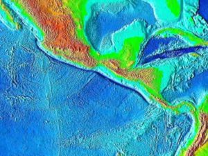
By volume, the largest portion of a subducting plate is its bottom layer, which comprises upper mantle material. Estimates of the amount of water in down-going slabs of upper mantle vary widely: Some suggest that worldwide, subduction zones have swallowed more than two oceans’ worth of water in the past 540 million years. However, new research by Miller et al. suggests that water transport at the Middle America Trench subduction zone is an order of magnitude less than previously estimated.
As a plate approaches a subduction zone, it bends downward, causing faults to form. Models and earlier observations have suggested that this bending and faulting allow seawater to infiltrate into the upper mantle, where it fills cracks in fault zones, reacts with olivine to produce serpentine, and is later carried deeper into the subduction zone.
Previous estimates of how much water reaches the upper mantle along bending faults have relied on measurements of the speed of seismic waves as they pass through a subducting plate. However, those measurements and estimates could not discern whether the upper mantle layer is uniformly hydrated or whether water is confined to bending fault zones.
To address that limitation, the new study accounted for seismic anisotropy characterizing how the speed of seismic waves depends on the direction they travel through a material. The researchers used data collected by seafloor seismometers to measure seismic anisotropy along the Middle America Trench near Nicaragua, which enabled a much more detailed picture of upper mantle hydration.
The data revealed that in the region studied, water storage in the upper mantle is limited to serpentinized fault zones that thin rapidly with depth, suggesting that fault dynamics and serpentinization reaction kinetics prevent seawater from hydrating the mantle between bending faults. New estimates of water transport that incorporate this finding are an order of magnitude lower than previous estimates for the Middle America Trench. Because the same processes occur at other subduction zones, the researchers report that far less water may be transported worldwide than previously estimated.
Reference:
Nathaniel C. Miller et al. Limited Mantle Hydration by Bending Faults at the Middle America Trench, Journal of Geophysical Research: Solid Earth (2020). DOI: 10.1029/2020JB020982
Note: The above post is reprinted from materials provided by American Geophysical Union. The original article was written by Sarah Stanley.


