Under the waters of the eastern Alborán Sea and buried at the shadow of an old volcanic edifice lies a body of sediments that may have been originated by a massive flood that refilled a partially desiccated Mediterranean 5.3 million years ago. This mass of sediments, seen in seismic reflection profiles, represents new possible megaflood deposit of the so-called Zanclean flood, according to a new article published in “Earth-Science Reviews” journal.
This review study summarises the latest stratigraphic pieces of evidence published suporting the Zanclean flood hypothesis. Zanclean flood is an event proposed for the termination of the Messinian Salinity Crisis, during which the Mediterranean Sea underwent a period of isolation from the Atlantic Ocean evolving into giant saline sea about 6 million years ago.
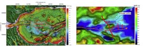
“The identified sediments are compatible with a megaflood event refilling the Mediterranean Sea through the Strait of Gibraltar. It’s an enlarged body deposited in the protected area at the lee side of a submarine volcano”, said Daniel García-Castellanos, researcher at Institute of Earth Sciences Jaume Almera of the Spanish Scientific Research Council (ICTJA-CISC) and leading author of the study.
According to the research, the newly identified deposits form an elongated body up to 163 m thick, 35 km long and 7 km wide. The identification of these deposits is based on seismic reflection profiles of the sea subsurface of the eastern Alborán basin. This deposit is parallel to the main flood erosive channel which was identified in 2009 in the Alborán basin.
This erosive channel extends along 390 km from the Gulf of Cadiz (Atlantic Ocean) until the Algerian Basin, through the Strait of Gibraltar and crossing the deepest parts of the Alboran Sea. An outburst flood erosion may have eroded the channel due to the breaching of the Strait of Gibraltar once the connection between the Atlantic Ocean and the Mediterranean Sea was restored about 5,3 million years ago.
Once the massive inflow of water entered in the Alboran basin, the channel split into two branches to overcome the topographic obstacles in its path. The volcanic edifice may have been one of these topographic obstacles during the flood leading to the deposition of the recently identified sediments along the seamount lee side.
Other pieces of evidence in the Eastern Mediterranean:
These sediments identified in the Alborán Sea can be added to the rest of evidence found and published in recent years that support the hypothesis of a massive flood and are summarised in the present article.
The Noto Canyon, in the northern Malta Escarpment, and a body of sediments of up to 860 m in thickness buried at the east of this canyon are two of the other pieces of evidence proposed in this article that may sustain the megaflood hypothesis. Both parts of evidence were analysed in a previous study published in Scientific Reports in 2018.
However, and despite all summarised pieces of evidence, Daniel García-Castellanos is cautious. “Ten years after publishing the first observations that were related with the Zanclean flood we are still finding new evidences to sustain it, but they are not conclusive. All of the evidences that have been summarised in this article may have other possible interpretations and, before convincing the scientific community it will be necessary to have other studies that consider the hypothesis from other angles”, said García-Castellanos.
Researchers from the University of Malta, the Helmholtz Centre for Ocean Research (GEOMAR), the Instituto de Ciencias del Mar (ICM-CSIC), IstitutoNazionale di oceanografia e di geofisicaSperimentale (OGS) and the University of Sevilla also participated in the study.
Reference:
Garcia-Castellanos, D., Micallef, A., Estrada, F., Camerlenghi, A., Ercilla, G., Periáñez, R., & Abril, J. M. (2020). The Zancleanmegaflood of the Mediterranean – Searching for independent evidence.Earth-Science Reviews, 201, 103061. https://doi.org/10.1016/j.earscirev.2019.103061
Note: The above post is reprinted from materials provided by Institue of Earth Sciences Jaume Almera(ICTJA-CSIC).


