The roles of “climate change” versus “tectonics” that dominate erosion and sediment transport over geological time scales have long been a hot topic in Earth science. How to effectively separate their respective roles is a big challenge, like the famous “chicken or egg” question.
A new study led by Prof. Jin Zhangdong from the Institute of Earth Environment (IEE) of the Chinese Academy of Sciences provided a new insight on the interplay between climate and tectonics from a sediment record in the Zipingpu Reservoir around the 2008 Wenchuan earthquake. The findings were published in Science Advances on June 12.
Infrequent extreme events such as large earthquakes pose hazards and have lasting impacts on landscapes and biogeochemical cycles. Sediments provide valuable records of past events, but unambiguously identifying event deposits is challenging because of nonlinear sediment transport processes and poor age control.
The Zipingpu Reservoir, with annually resolved sediments, provides a unique opportunity to document the link between a large earthquake and its sedimentary signature, because it was completed in September 2004 and is located downstream of the area impacted by the 2008 Wenchuan earthquake.
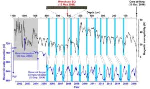
In October 2016, a 10.89-m sediment core back to the river bed was recovered from the Zipingpu Reservoir. An age model for the core was developed based on the correlation between sedimentary magnetic susceptibility and reservoir water level. The boundary of the 2008 Wenchuan earthquake was then assigned to the core depth of 6.20 m (Fig. 1). This is the first time that a 10-year sediment core was dated to annual resolution.
Based on the precise annual chronology, the roles of a single large earthquake and climate on erosion and sediment transfer were evaluated along with sedimentary and hydrometeorological data. The records demonstrated that the grain size and Rb/Sr ratios of the sediments in the Zipingpu Reservoir responded immediately to the earthquake. However, the changes were muted until two years after the event.
The most obvious seismic signals occurred in 2010 when intense monsoonal runoff facilitated fast material export and drove accumulation of coarser grains and lower Rb/Sr sediments, which were then sustained for several years (Fig. 2).
The results indicated that, although the earthquake mobilized very large amounts of sediment by landsliding, hydrological forcing was necessary to transport this debris from hillslopes to downstream sediment stores, even in a location proximal to the mountain front.
The delayed response highlighted the role of intense monsoonal rainfall in propagating tectonic signals into sedimentary archives.
This study provides direct evidence that can inform the interpretation of paleorecords and help to illuminate the ways in which sedimentary archives reflect the complex interaction of tectonics and climate in controlling sediment transfer in tectonically active mountain ranges.
Reference:
Fei Zhang et al, Monsoonal control on a delayed response of sedimentation to the 2008 Wenchuan earthquake, Science Advances (2019). DOI: 10.1126/sciadv.aav7110
Note: The above post is reprinted from materials provided by Chinese Academy of Sciences.


