Zhangye Danxia, China
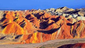
These rainbow mountains look like something out of a painting. The Danxia landforms, found in China’s Gansu Province, are made of strips of red sandstone that were deposited over millions of years, like slices of a layered cake.
Wave Rock, Australia
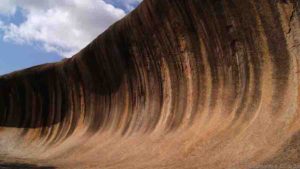
This concave rock is 14 m high and 110 m long. It is part of the northern side of Hyden Rock, a giant granite outcrop over 2.7 billion years old, located in Hyden Wildlife Park in Western Australia.
The wave is believed to have formed by the action of running water on granite. The colourful streaks on its face are made of minerals left behind by rainwater run-off.
Giant’s Causeway, Northern Ireland
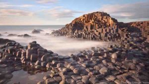
These massive hexagonal black basalt columns rise like steps and interlock neatly. There are over 40,000.
They probably formed after volcanic activity 50-60 million years ago. The sizes of the columns were most likely determined by the speed at which the erupted lava cooled.
How Giant’s Causeway and Devils Postpile were formed
Fingal’s Cave, Scotland
Devils Tower
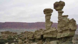
Vermillion Cliffs National Monument, Arizona
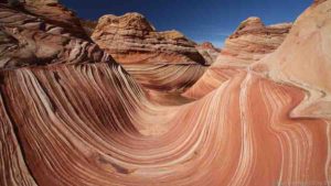
Popular among hikers, Vermillion Cliffs is a treasure trove of deep canyons and steep cliffs. It is also home to “The Wave” (pictured), which is made up of undulating sandstone.
The Monument is located on the Colorado Plateau, and gets its rich reddish hues from the sandstone that formed the landscape. The colours of the site change as the day progresses.
Cave of the Crystals, Mexico
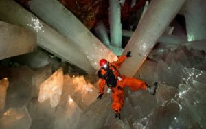
This cave contains gigantic, sword-like gypsum crystals. It is 300m underground in the Naica Mine in the Mexican state of Chihuahua. It was discovered by two brothers drilling for lead and silver.
The enormous crystals are believed to have formed when gypsum-saturated groundwater flowed through the caves, and was heated and cooled by hot magma below. Some of the largest crystals may be over 500,000 years old.
Cave of Crystals “Giant Crystal Cave”
Fairy Chimneys, Turkey
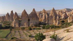
These strange conical spires are found in the Cappadocia region of Turkey.
Several million years ago, active volcanoes spewed volcanic ash that covered the ground. Rainwater and wind eroded the soft compressed volcanic ash, leaving behind the harder overlying basalts, forming the fairy chimneys.
The Great Blue Hole, Belize
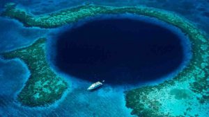
This underwater sinkhole is 320 m wide and 125 m deep, and a major scuba diving attraction. It is part of the Belize Barrier Reef, which is in turn part of the Mesoamerican Reef.
This hole is believed to have formed during the recent ice ages, when a submerged limestone cave system collapsed due to changes in the sea level. Huge stalactites and stalagmites are found in the hole, which contain records of past climates.
Moeraki Boulders, New Zealand
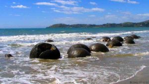
Resembling giant turtle shells, these spherical boulders lie strewn on New Zealand’s Koekohe Beach.
These boulders started forming in sediments on the sea floor over 60 million years ago. Carbonates built up around a central core, similar to the way pearls form around a speck of grit.
According to Maori legends, the boulders are remnants of gourds and eel baskets, washed ashore from the wreck of a sailing canoe.
Stone Forest, China
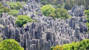
Blade-like columns of limestone, many over 10 m tall, form a landscape that resembles a forest of stones. The region is a UNESCO World Heritage Site.
The stone forests formed some 270 million years ago in what was once a shallow sea. Sandstone and limestone accumulated in the basin, and was eventually pushed up into the air. The rocks were then shaped by wind and water to create these spectacular stone pillars.
Valley of the Moon, Argentina
Arid and rugged, this barren landscape looks like – you guessed it – the surface of the Moon. But it is actually a fossil graveyard.
The site contains undisturbed deposits from 250-200 million years ago. Fossils of some of the oldest dinosaurs, fish, amphibians, reptiles and over 100 species of plants have been found. There are also huge petrified tree trunks.
Chocolate Hills, the Philippines
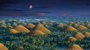
There are about 1500 of these limestone mounds in Bohol province in the Philippines. They are normally covered by grass, but turn a deep-brown colour during the dry season.
In 1988, the Chocolate Hills were declared the Philippines’ third National Geological Monument.
Eye of the Sahara, Mauritania

Formally known as the Richat Structure, the Eye of the Sahara looks like a bullseye from above.
Located in the Sahara desert, it is a dome-shaped rock structure about 50 km across. Once thought to have been caused by a meteorite impact, it is now believed to have formed from uplifted rock that was later eroded.
Bryce Canyon National Park, Utah
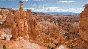
Located on the Colorado Plateau, the Bryce Canyon in southern Utah is a natural amphitheatre filled with spires and hoodoos. The Paiute Native Americans called it “red rocks standing like men in a bowl-shaped canyon”.
The hoodoos were formed when water repeatedly froze and melted in the vertical cracks of sedimentary rocks. Some hoodoos are taller than a 10-storey building.
San Andreas Fault, California
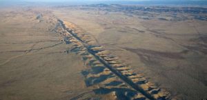
Credit: Wikipedia.
This is one giant fracture on the earth’s crust, nearly 1,300 km long. The fault line began forming over 30 million years ago when two massive tectonic plates – the Pacific and North American – collided.
A major earthquake may well strike the San Andreas Fault in the coming decades.
Blue Lake Cave, Brazil
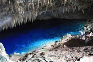
Blue Lake Cave is a cave located in Bonito, Mato Grosso do Sul, Brazil. The cave has been listed as a protected area by IPHAN since 1978.
Gruta Do Lago Azul, or the Blue Lake Grotto, the large cave is filled with a pool of astonishingly clear blue water. Thought to be over 200 feet deep, the water turns a particularly beautiful blue when sunlight shines through a hole in the ceiling of the cave, and makes the water shimmer in the light.
Champagne Pool, New Zealand
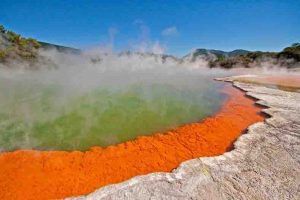
Champagne Pool is a prominent geothermal feature within the Waiotapu geothermal area in the North Island of New Zealand.
Cerro de los Siete Colores “The Hill of Seven Colors”, Argentina
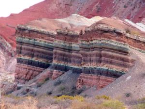
Cerro de los Siete Colores (The Hill of Seven Colors) is one of the hills bordering the Quebrada de Purmamarca which is in turn is a western branch of the Quebrada de Humahuaca up to Cuesta del Lipán, in Jujuy Province, Argentina.
Marble Caves, Chile
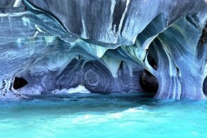
The Marble Caves is geological formation of unusual beauty. These caves have formed in a pure marble and are bathed in the deep blue water of General Carrera Lake
The Paria Mountains, United States
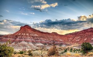
Paria or Pahreah, is a ghost town on the Paria River in Grand Staircase-Escalante National Monument in central Kane County, Utah, United States. It was inhabited from 1870 to 1929, and later used as a filming location.
Travertine Hot Springs at Pamukkale, Turkey
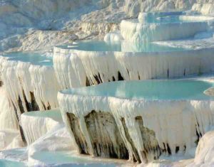
Pamukkale, meaning “cotton castle” in Turkish, is a natural site in Denizli Province in southwestern Turkey. The city contains hot springs and travertines, terraces of carbonate minerals left by the flowing water. It is located in Turkey’s Inner Aegean region, in the River Menderes valley, which has a temperate climate for most of the year.
Travertine terrace formations at Pamukkale, Turkey. May 21, 2011
The Realmonte Salt Mine in Sicily, Italy
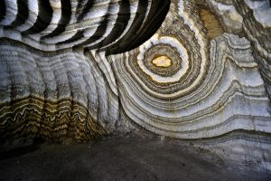
There are currently three salt mines Realmonte in the province of Agrigento and Racalmuto and Petralia, in the province of Palermo, managed by the company Italkali . The Realmonte field, overlooking the southern coast of Sicily, about four
kilometers from Agrigento and a kilometer from Porto Empedocle.
Watermelon Valley, Egypt
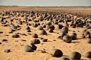
“Watermelon Valley” Chert nodules of the Drunka Formation (Lower Eocene) are mostly spherical, have diameters from 40 to 120 cm, are quasi-uniformly spaced 2–3 m apart in the plane of bedding, have concentric internal structure and, except for rare small (<6 cm) solid chert nodules, are less than 85% chertified.
The Twelve Apostles, Australia
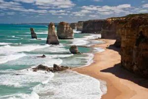
The Twelve Apostles is a collection of limestone stacks off the shore of the Port Campbell National Park, by the Great Ocean Road in Victoria, Australia. Their proximity to one another has made the site a popular tourist attraction.


