At least 210 people were killed in Iran and Iraq on Sunday when a powerful magnitude 7.3 earthquake hit the region, state media in the two countries said, as rescuers searched for dozens trapped under rubble.
Officials expected the casualty toll to rise when search and rescue teams reached remote areas of Iran.
A quake registering a magnitude between 7 and 7.9 can inflict widespread and heavy damage. Moreover, many houses in rural areas of Iran are made of mud bricks that can crumble easily in a quake.
The earthquake was felt in several provinces of Iran but the hardest hit province was Kermanshah, which announced three days of mourning.
Tectonic Summary
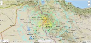
The November 12, 2017 M 7.3 earthquake near the Iran-Iraq border in northwest Iran (220 km northeast of Baghdad, Iraq) occurred as the result of oblique-thrust faulting at mid-crustal depth (~25 km). Preliminary focal mechanism solutions for the event indicate rupture occurred on a fault dipping shallowly to the east-northeast, or on a fault dipping steeply to the southwest. At the location of this earthquake, the Arabia plate is moving towards the north with respect to Eurasia at a rate of about 26 mm/yr. The two plates converge along a northwest-striking plate boundary in the general vicinity of this earthquake, driving the uplift of the Zagros mountains in Iran. The location of the event and the shallow, northeast-dipping plane of the focal mechanism solution are consistent with rupture of a plate boundary related structure in this region.
While commonly plotted as points on maps, earthquakes of this size are more appropriately described as slip over a larger fault area. Oblique-thrust-faulting events of the size of the November 12th, 2017 earthquake are typically about 65×25 km (length x width).
Over the preceding century, the region within 250 km of the hypocenter of the November 12, 2017 earthquake has experienced 4 other M6+ earthquakes. The most recent of these was a M 6.1 earthquake about 100 km to the south of the November 2017 event in January 1967. In the late 1950s and early 1960s, a cluster of M 6.0-6.7 earthquakes occurred along the plate boundary about 200 km to the southeast of today’s earthquake. In November 2013, a pair of M 5.6 and M 5.8 earthquakes occurred about 60 km south of the November 2017 event. They are not known to have caused significant damage or fatalities. A M 7.4 earthquake in June 1990, 400 km to the northeast of the November 12, 2017 event, caused between 40,000-50,000 fatalities, more than 60,000 injuries, and left more than 600,000 homeless in the in the Rasht-Qazvin-Zanjan area of Iran.
Note: The above post is reprinted from materials provided by USGS.


 occurred as the result of oblique-thr)