Shinji Takarada and members of the Caldera Volcano Research Group, the Research Institute of Earthquake and Volcano Geology, the Geological Survey of Japan, the National Institute of Advanced Industrial Science and Technology, have created the “Eastern Asia Earthquake and Volcanic Hazards Information Map” summarizing past disaster information on large-scale earthquakes, volcanic eruptions and the tsunamis that they triggered.
The “Eastern Asia Earthquake and Volcanic Hazards Information Map” summarizes past disaster information on large-scale earthquakes, volcanic eruptions and the tsunamis that they triggered on a single geological map. Displaying the disaster scale, and the number and causes of fatalities on the map in icons enable the viewers to have a good grasp of the hazard situation of a particular area at a glance. The map is expected to raise risk management awareness among corporations and travelers in East Asia. It can also be used as basic data for disaster mitigation planning and hazard map creation. The map in image format has been made public on the Geological Survey of Japan website (https://www.gsj.jp/HomePageJP.html) since May 20, 2016 and will be distributed to relevant institutions and researchers worldwide. There are also plans to publish the hazard information map in GIS digital format on the G-EVER Asia-Pacific Region Earthquake and Volcanic Hazard Information System website, making it possible to overlay this data with other information such as population for other type of research.
The hazard information map will be presented at the meeting of Japan Geoscience Union members in Makuhari Messe, Chiba City, Chiba Prefecture on May 22 to 26, 2016, and at the most important international conference in the field of geoscience, the 35th International Geological Congressin Cape Town, South Africa on August 27 to September 4, 2016.
Eastern Asia covering countries like Japan, Indonesia and the Philippines is one of the regions of the world most frequently struck by large-scale natural disasters such as earthquakes, volcanic eruptions, and the tsunamis that they triggered. In the present global society, occurrence of large-scale disaster which affects factories could have devastating effect not only in the affected region but the entire world. For this reason, countries around the world are deeply concerned about disaster mitigation measures in East Asia, which hosts many production sites that are exposed to the aforementioned disasters. The Great East Japan Earthquake on March 11, 2011 strongly reminds society that large-scale disasters could bring unimaginable destruction and human suffering, even if they are infrequent and preparing for such disasters is very important.
However, until now, information on large-scale disasters is owned by various countries and there is nothing with which people could see the overall Eastern Asian hazard information in detail.
AIST formed the Asia-Pacific Region Earthquake and Volcanic Eruption Risk Management (G-EVER) Promotion Team in the Geological Survey of Japan in 2012, during the first anniversary of the Great East Japan Earthquake, and launched the “Eastern Asia Earthquake and Volcanic Hazards Information Map” project. The geological surveys and related research institutes in East Asia participated in this project which aims to mitigate disasters caused by earthquakes and volcanic eruptions. The participating organizations provided disaster information about large-scale earthquakes, volcanic eruptions and the triggered tsunamis like the disaster scale and the number and causes of fatalities, with the aim of displaying the information in an easy to understand format on a single map.
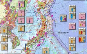
Earthquakes and volcanic eruptions after 1850AD and 1400AD, respectively, are collated and displayed on a single map. Information about tsunamis triggered by volcanic eruptions and earthquakes like heights and the areas affected, which have been given great attention after the Great East Japan Earthquake, are displayed on the map. Also included are the locations of active faults and distribution of volcanic ash. The number and causes of fatalities due to disasters are determined and displayed on the map using color coded icons to be easily understood by viewers (Fig. 1).
Earthquake information displayed on the map includes magnitude, location and depth of epicenters, source regions and triggered tsunamis. The causes of earthquake fatalities are classified into fire, tsunami, building collapse, landslide and others. These types of information are displayed on the map in color coded icons. Locations of active volcanoes and the areas covered by large-scale pyroclastic flows and ash fall, which are indicated in broken lines, are also displayed. The causes of volcanic fatalities are classified into pyroclastic flows, ballistics, lahar, ash fall, tsunami, and others. These types of information are displayed on the map in color coded icons.
Displaying hazard information on a single map makes it possible to easily determine the relationship between geology and hazards. It is clearly shown on the map that volcanic eruptions and earthquakes seldom happen in relatively old-age geological regions. It is also possible to know the disaster-prone areas, the scale and type of disasters and the areas affected by tsunamis and volcanic ash falls at a glance. The map could be easily understood by experts and non-technical people making it very useful for disaster mitigation measures in East Asia. Detailed data that cannot be fully displayed on the information map is written at the back of the map in Japanese and English. It is expected that various agencies will use it in conjunction with the detailed earthquake and volcanic hazard information. The “Eastern Asia Earthquake and Volcanic Hazards Information Map” in image format was available for download at the geological map catalog (geoscience map of Asia) page on the Geological Survey of Japan website (https://www.gsj.jp/HomePageJP.html) since May 20, 2016.
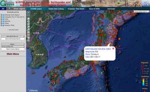
The original data of the “Eastern Asia Earthquake and Volcanic Hazards Information Map” were created in digital in GIS format and the researchers plan to make it accessible on the G-EVER Asia-Pacific Region Earthquake and Volcanic Hazard Information System, where users can zoom in to the area they wish to see, such as Japan, and acquire more detailed information (Fig. 2). Earthquake information is updated in real time in the system making the users view the latest disaster information. Using the search function, it is possible to query the system’s database based on the date and region where they occurred, the disaster scale, or the number of fatalities.
By investigating the affected areas and causes of damage due to earthquakes, volcanic eruptions, and the triggered tsunamis, and providing the results in GIS format, important information processing could further be implemented. By combining hazard data with various information including population and transportation network, it is possible to evaluate the hazard risks that might be caused by future earthquakes, volcanic eruptions and tsunamis. Furthermore, government agencies and local governments responsible for disaster mitigation in various countries will be able to create hazard maps based on the data. It can also be used for disaster mitigation research by universities and research institutions. In addition, it is expected that the data will be used as reference materials for educational institutions to provide disaster mitigation education. It could be a source of information for companies operating in Japan and abroad to formulate measures against disasters and business continuity plans (BCP), and reference data for tourists.
Currently, the “Eastern Asia Earthquake and Volcanic Hazards Information Map” is displayed in English, but in the future it will be published using the languages of various countries, including Japanese. Furthermore, Eikichi Tsukuda, Director General of the Geological Survey of Japan, who promoted the “Eastern Asia Earthquake and Volcanic Hazards Information Map” project, serves as the Asian representative to the Commission for the Geological Map of the World (CGMW) under the umbrella of UNESCO. As such, AIST has plans to distribute Eastern Asia earthquake and volcanic hazard information around the world using the “Eastern Asia Earthquake and Volcanic Hazards Information Map.”
Note: The above post is reprinted from materials provided by Advanced Industrial Science and Technology.


