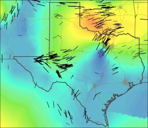
Stanford geophysicists have compiled the most detailed maps yet of the geologic forces controlling the locations, types and magnitudes of earthquakes in Texas and Oklahoma.
These new “stress maps,” published in the journals Geophysical Research Letters and Bulletin of the Seismological Society of America, provide insight into the nature of the faults associated with recent temblors, many of which appear to have been triggered by the injection of wastewater deep underground.
“These maps help explain why injection-induced earthquakes have occurred in some areas, and provide a basis for making quantitative predictions about the potential for seismic activity resulting from fluid injection,” said study co-author Mark Zoback, the Benjamin M. Page Professor of Geophysics in Stanford’s School of Earth, Energy & Environmental Sciences.
To create these stress maps, Zoback and his graduate students Jens-Erik Lund Snee and Richard Alt interpreted data from different parts of Texas and Oklahoma donated by oil and gas companies. “Companies routinely collect data that can be used for assessing the state of stress in the Earth as part of their normal oil and gas operations,” Lund Snee said.
When combined with information about the faults present in a given area, the scientists were able to assess which faults are likely to be problematic and why. In the areas where induced earthquakes have occurred in Texas and Oklahoma, the Stanford scientists show that a relatively small increase of pore pressure – the pressure of fluids within the fractures and cavities of rocks – would have been sufficient to trigger slip.
In a related paper published recently in the journal Geology, graduate student F. Rall Walsh and Zoback present a methodology for assessing which faults are susceptible for earthquake triggering and which are not.
The Stanford scientists also found that many of the recent earthquakes in Texas that have been suspected as being triggered by wastewater injection occurred on faults that – according to the new map – have orientations that are nearly ideal for producing earthquakes. Hence, doing this kind of study in advance of planned injection activities could be very helpful.
“By identifying which faults are potentially active in advance, companies and regulators can avoid problematic faults during fluid injection and prevent the induced earthquakes from happening before they do,” Zoback said.
Reference:
Jens-Erik Lund Snee et al. State of stress in Texas: Implications for induced seismicity, Geophysical Research Letters (2016). DOI: 10.1002/2016GL070974
F. Rall Walsh et al. Probabilistic assessment of potential fault slip related to injection-induced earthquakes: Application to north-central Oklahoma, USA, Geology (2016). DOI: 10.1130/G38275.1
Note: The above post is reprinted from materials provided by Stanford University.


