When a strong earthquake hits an urban area, prompt rescue operations can minimize the number of victims. Logically, the probability of saving a human trapped under debris or injured during the course of a disaster decreases exponentially as function of time, vanishing almost completely after about few hours. The Tokyo Fire Fighting Department Planning Section [2002] has quantified this further, stating that rescue within 3 hours is desirable and survival rate is drastically lower after 72 hours.
Past disasters—like the magnitude 6.6 quake that struck Iran on 26 December 2003—support this assessment. As a result of that earthquake, more than 43,000 people died, and only 30 were saved, despite the intervention of 1600 rescuers from 43 nations. This tragic outcome is likely related to the fact that many rescuers didn’t arrive until after 3 days.
The impact of a strong earthquake on an urban center can be considerably reduced by an efficient emergency management center, through timely and targeted actions immediately following the quake. A real-time urban seismic network—sensors laid out in a grid through a city—could help emergency management centers by providing immediate alert and postearthquake information summarized in maps of ground motion.
Researchers are using new technological advances to develop one such urban seismic network in Acireale, Italy. The network will not use traditional seismometers; rather, they will harness the less expensive technology of accelerometers. Once operational, it will be the first urban seismic network in Europe.
Goals of an Urban Seismic Network
Urban seismic networks allow the disaster’s first responders to manage available resources, such as personnel and equipment needed to rescue people. Rescue operations and verification of damage to buildings could then be carried out according to a logical priority according to where the highest shaking was measured by the seismic network. Such an approach would minimize secondary effects induced by an earthquake and allow officials to protect critical infrastructure, thereby mitigating the economic and social costs of the earthquake.
Accelerometers to the Rescue
The high costs associated with the construction and installation of traditional seismic stations has made it nearly impossible to realize a true seismic network on an urban scale. However, recent technological developments in the field of microelectromechanical systems (MEMS) sensors, which can be configured to detect minute accelerations, may allow scientists to create an urban seismic network at low cost.
MEMS sensors are a set of highly miniaturized devices that receive information from the environment and translate physical quantities they sense into electrical impulses. Depending on how the sensors are configured, they can measure phenomena of various kinds: mechanical (sound, acceleration, and pressure), thermal (temperature and heat flux), biological (cell potential), chemical (pH), optical (intensity of light radiation and spectroscopy), and magnetic (intensity of flow). The MEMS devices that will be used in the project integrate a three-axis accelerometer, which can measure both constant accelerations (usable as a tilt sensor) and those that vary in time (used to measure the oscillation induced by an earthquake).
In the 1990s, MEMS sensors revolutionized the automotive airbag system and are today widely used in laptops, games controllers, drones, and mobile phones. When configured to measure ground shaking, the sensitivity and the dynamic range of these sensors are high enough to allow the researchers to record earthquakes of moderate magnitude even at a distance of several tens of kilometers [D’Alessandro and D’Anna, 2003; Evans et al., 2014]. Because of their low cost and their small size, MEMS accelerometers could be easily installed in urban areas to achieve a seismic network with a high density of measuring points.
In the past decade, a number of research institutes that focus on geophysics and seismology have shown interest in this promising technology. In California and Japan, scientists are developing networks consisting entirely of MEMS sensors. These include the Quake-Catcher Network, managed by Stanford University [Cochran et al., 2009; Chung et al., 2011; Kohler et al., 2013]; the Community Seismic Network, managed by the California Institute of Technology [Clayton et al., 2011; Kohler et al., 2013]; and the Home Seismometer Network, managed by the Japan Meteorological Agency [Horiuchi et al., 2009].
First European Urban Seismic Network
In September 2015, the Italian Ministry of Education, University and Research funded a 3-year project to create the first European urban seismic network using MEMS technology. The project is called Monitoring of Earthquakes through MEMS Sensors (MEMS project).
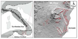
We chose the municipality of Acireale, Italy, an urban area particularly vulnerable to earthquake hazards [Azzaro et al., 2010, 2013], as a pilot site for the MEMS project (Sicily, Italy; Figure 1). Acireale is located on the southeastern slopes of Sicily’s Etna volcano and is vulnerable to damage from tectonic and volcanic earthquakes.
Founded in the 14th century, Acireale contains many seismically vulnerable buildings of historical and cultural value. In the past 2 centuries, more than 190 damaging earthquakes have occurred in the Etna region, almost 1 per year. This includes an earthquake sequence that began with a main shock on 29 October 2002—following this magnitude 4.4 event, more than 400 buildings in Acireale were declared uninhabitable [Azzaro et al., 2010].

We aim to develop an urban seismic network comprising about 200 MEMS stations (Figure 2). Each station will consist of a three-axis digital MEMS accelerometer connected to a computer for on-site signals preprocessing. Each station will be supplied with a GPS for time synchronization and an Internet connection for data transmission to a processing center. Should an earthquake cause a power outage, the station can function autonomously for about 2 hours, thanks to the buffer battery shown in Figure 2.
The MEMS stations will be located mainly inside buildings characterized by high vulnerability (old buildings that weren’t built to withstand high shaking) and high flux of people moving in and out, such as schools, hospitals, public buildings, and places of worship. The geometry of the network will be designed to create homogeneous coverage of the urban center, with a high enough density of stations in the vicinity of the well-known faults.
The network’s success will depend on our ability to implement algorithms able to prevent false alarms. Such algorithms will allow the creation of a shaking map only if a significant percentage of the MEMS stations have simultaneously detected a shaking event—if shaking is human made (e.g., an explosion), only the nearest stations would detect it, but an earthquake would be recorded by many stations. Automatic detection of patterns in waveforms that signal a specific seismic source will also be helpful.
What Can We Learn?
If all goes well, the network will be operational by the end of 2017. The seismic waveforms captured by the sensors will be processed in real time to identify several shaking parameters that will be used to create shake maps at the urban scale. The earthquake waveforms collected by the network will also be used to reconstruct the movement along the faults that caused the earthquakes to map seismic hazards and risks on a fine scale for the area covered.
The system could be used to implement a site-specific earthquake early warning system [Horiuchi et al., 2009]. Such a system could enhance the safety margin of specific critical engineered systems—such as energy plants or high-speed railway networks—in real time, mitigating the seismic risk by triggering automatic actions that aim to shelter people from exposure to shaking.
If successful, the MEMS project could provide a useful tool to reduce the seismic risk by increasing the safety of the population of the urban area covered by the network. Such a system could be quickly extended to other areas of high seismic risk, revolutionizing how communities monitor earthquakes. Communities would no longer need to focus on the characterization of earthquakes in terms of focus parameters (e.g., hypocenter and magnitude). Instead, networks like the MEMS project would characterize shaking by direct measurements of how shaking affects a city, neighborhood by neighborhood.
Note: The above post is reprinted from materials provided by Earth & Space Science News/American Geophysical Union. The original article was written by Antonino D’Alessandro.


