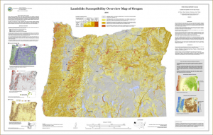
A new landslide susceptibility map of Oregon helps identify regions of the state that may be at risk for future landslides.
“Oregon is prone to landslides,” says Bill Burns, engineering geologist for the Oregon Department of Geology and Mineral Industries (DOGAMI). “This map points us toward priority areas for future in-depth mapping and study of our landslide hazards, and helps Oregonians better understand the potential hazard in their own communities.”
More than a third of Oregon’s land has very high or high landslide susceptibility. Very high susceptibility means the area is an existing landslide; high susceptibility means landsliding is likely. Landslides can be triggered by factors such as intense rainfall, rapid snow melt, and freeze/thaw cycles. In some areas of the state, particularly western Oregon, very high and high susceptibility percentages are much higher. Read the full report: bit.ly/1KHY2yZ
The mapping marks the first time since 1982, when the U.S. Geological Survey published a landslide overview map of the United States, that there’s been a look at the landslide susceptibility of the entire state. The accompanying report includes susceptibility percentages for all Oregon counties, incorporated cities, and some watersheds.
A 2013 Clackamas County landslide hazard and risk study is an example of the type of detailed study that Burns says is critical for Oregon’s landslide-susceptible locations. In that study, DOGAMI identified 2,885 existing landslides, on top of which are $1 billion worth of buildings and land with almost 8,000 people.
“Studying landslides helps Oregon understand where taking action might decrease the risk to people, buildings and infrastructure,” Burns says.
The new landslide hazard information can also help Oregonians protect themselves and their property. Knowing which areas may be susceptible to landslides helps people identify places to avoid during extreme weather, and helps people determine whether hiring a geotechnical professional to evaluate their property may be necessary. The new mapping has been added to SLIDO, DOGAMI’s interactive landslide hazard map: bit.ly/oregonslido.
Map
Reference:
DOGAMI Open-File Report O-16-02, Landslide Susceptibility Overview Map of Oregon by William J. Burns, Katherine A. Mickelson, and Ian P. Madin contains a map, report and GIS data.Download this publication for free at bit.ly/1KHY2yZ
Note: The above post is reprinted from materials provided by Oregon Department of GeologY and Mineral Industries.


