Growing up in Ridgefield, Sean LaHusen could see a prominent example of America’s shifting landscape. He didn’t realize he was looking at a possible career.
But for more than a year, LaHusen’s workplace has been defined by geomorphology: specifically, mud in motion. The University of Washington doctoral student is researching the area around the Oso landslide that killed 43 people on March 22, 2014.
LaHusen was the lead author of a paper published recently in the journal Geology. It examined the frequency of slides along that stretch of the Stillaguamish River in Northwest Washington.
Researchers used airborne lasers and dug woody debris from centuries-old slopes to show that the pace of slides is much faster than people thought.
It’s all part of trying to determine when it might happen again.
“The only way to forecast is to look into the past and see how these hill slopes fall apart,” LaHusen said.
Rather than occurring every few thousand years, as some people thought, slopes in the Oso area have been collapsing every 500 years or so. And over the last 2,000 years, the slides have been occurring at an even faster rate — about every 140 years.
His own environment was a factor in the study, LaHusen said. “I was inspired by the landscape of the Pacific Northwest. It is such a dynamic landscape: not just landslides, but volcanic activity.
“Growing up, we had a view of Mount St. Helens: a cool spot. I ended up climbing it a few times,” he said.
He wasn’t thinking about geology when he enrolled at Western Washington University, however. The 2009 Ridgefield High honor graduate was looking at a different branch of science, even though his dad, Rick LaHusen, worked for 30 years at the U.S. Geological Survey’s volcano observatory in Vancouver.
Appreciating outdoors
There certainly were family influences, though.
“I’m not in geology because my dad works for the USGS,” the University of Washington researcher said. “I’m a scientist who is interested in the environment because of my upbringing. I grew up with a deep appreciation of the outdoors. My folks would always take me out backpacking and skiing, which had a pretty profound impact on how I wanted to spend my life.
“I also got a respect for the scientific method, and the process of learning about our environment.”
“Of course, I am terribly proud of Sean,” Rick LaHusen said in an email message. “As Sean said, and must be emphasized, he has been forging his own career path.
“We did enjoy many adventures together, camping, mountain biking, skiing, climbing, hiking and backpacking in the Pacific Northwest,” said the retired hydrologist, who now is a volunteer at the Cascades Volcano Observatory. “Consequently, we share a great appreciation for the incredibly beautiful and dynamic landscapes in Washington and Oregon.”
It all was a factor in the younger LaHusen originally choosing environmental science as his major.
“A prerequisite was Geology 101. I had a fantastic teacher. I took a couple of her courses and it clicked for me. I changed to geology. The next year, I took a geomorphology course. It’s a study of landscapes and land forms and how the surface of the Earth changes,” he said.
“It’s very tangible; it changes on human scale. A lot of geology operates on time scales that are hard to grasp: millions and billions of years. We can see geomorphic processes in a human lifetime. It affects human societies,” he said, noting that the Oso mudslide “killed 43 people in one event, which is catastrophic.”
When he decided to pursue graduate studies at the University of Washington, he committed to landslide research. A few weeks later, the Oso slide struck.
LaHusen and his adviser, assistant professor Alison Duvall, set out to determine the dates of more than two dozen major slides along a 3.7-mile stretch of the Stillaguamish River near the Oso site.
Expensive, difficult
It’s interesting that nobody had studied it before, he said, although “Dating landslides can be tough. It’s not cheap and it’s not easy. It costs $300 per sample to run radiocarbon dating” of wood samples.
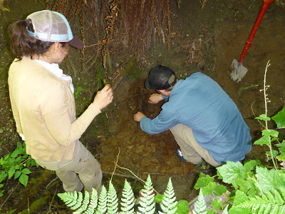
In obtaining those samples, “I’m basically bush-whacking,” LaHusen said. “I look for areas when a river cuts a gully, where a landslide deposit has been exposed naturally.”
He digs into the gully wall and looks for remnants of trees that were buried in mud centuries ago.
For specimens used in the recently published study, “We dug back really far into the gully wall — a meter, at least — to make sure the tree hadn’t just fallen into the gully.”
Slide deposits get smoother as they get older, so another important research tool was lidar (light detection and ranging).
A laser mounted on an airplane fires laser pulses to the ground, said Adam Booth, an assistant geology professor at Portland State University.
“It reflects off objects and returns to the plane,” said Booth, a co-author of the study. “The end product is a 3-D representation of the surface of the Earth.”
It’s much more revealing than aerial photography.
“From photos, all you see is the tops of vegetation,” Booth said. “For this study, some of that energy penetrates vegetation and bounces off the Earth’s surface. With lidar, you can see an image of what the ground looks like.”
Duvall and LaHusen were able to obtain woody debris from several old slide areas, but not all of them. By combining data from the radiocarbon-dated samples and the lidar imagery, researchers established a roughness-age scale.
“The roughness analysis helps extend (their findings) to places where they didn’t have access or were not able to find datable materials,” Booth said.
LaHusen and Duvall also are part of the university’s M-9 Project, studying the risks from a magnitude-9 earthquake along the Cascadia subduction zone.
They’re hoping to use the techniques from the Oso study to look at landslides in Washington that were triggered by a massive quake in 1700.
Scientists hope to learn whether they can develop simulations to predict which places in Washington are most vulnerable to earthquake-generated landslides.
Note: The above post is reprinted from materials provided by Columbian. The original article was written by Tom Vogt, Columbian Science, Military & History Reporter .


