If a volcano erupts at the bottom of the sea, does anybody see it? If that volcano is Axial Seamount, about 300 miles offshore and 1 mile deep, the answer is now: yes.
Thanks to a set of high-tech instruments installed last summer by the University of Washington to bring the deep sea online, what appears to be an eruption of Axial Volcano on April 23 was observed in real time by scientists on shore.
“It was an astonishing experience to see the changes taking place 300 miles away with no one anywhere nearby, and the data flowed back to land at the speed of light through the fiber-optic cable connected to Pacific City—and from there, to here on campus by the Internet, in milliseconds,” said John Delaney, a UW professor of oceanography who led the installation of the instruments as part of a larger effort sponsored by the National Science Foundation.
Delaney organized a workshop on campus in mid-April at which marine scientists discussed how this high-tech observatory would support their science. Then, just before midnight on April 23 until about noon the next day, the seismic activity went off the charts.
The gradually increasing rumblings of the mountain were documented over recent weeks by William Wilcock, a UW marine geophysicist who studies such systems.
During last week’s event, the earthquakes increased from hundreds per day to thousands per day, and the center of the volcanic crater dropped by about 6 feet (2 meters) over the course of 12 hours.
“The only way that could have happened was to have the magma move from beneath the caldera to some other location,” Delaney said, “which the earthquakes indicate is right along the edge of the caldera on the east side.”
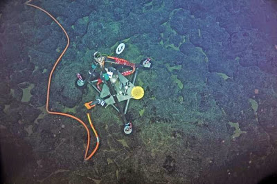
The seismic activity was recorded by eight seismometers that measure shaking up to 200 times per second around the caldera and at the base of the 3,000-foot seamount. The height of the caldera was tracked by the bottom pressure tilt instrument, which measures the pressure of the water overhead and then removes the effect of tides and waves to calculate its position.
The depth instrument was developed by Bill Chadwick, an oceanographer at Oregon State University and the National Oceanic and Atmospheric Administration who has also been tracking the activity at Axial Volcano and predicted that the volcano would erupt in 2015.
The most recent eruptions were in 1998 and 2011.
The volcano is located about 300 miles west of Astoria, Oregon, on the Juan de Fuca Ridge, part of the globe-girdling mid-ocean ridge system—a continuous, 70,000 km (43,500 miles) long submarine volcanic mountain range stretching around the world like the strings on a baseball, and where about 70 percent of the planet’s volcanic activity occurs. The highly energetic Axial Seamount, Delaney said, is viewed by many scientists as being representative of the myriad processes operating continuously along the powerful subsea volcanic chain that is present in every ocean.
“This exciting sequence of events documented by the OOI-Cabled Array at Axial Seamount gives us an entirely new view of how our planet works,” said Richard Murray, division director for ocean sciences at the National Science Foundation. “Although the OOI-Cabled Array is not yet fully operational, even with these preliminary observations we can see how the power of innovative instrumentation has the potential to teach us new things about volcanism, earthquakes and other vitally important scientific phenomena.”
The full set of instruments in the deep-sea observatory is scheduled to come online this year. A first maintenance cruise leaves from the UW in early July, and will let researchers and students further explore the aftermath of the volcanic activity.
Note : The above story is based on materials provided by University of Washington.


