A University of Dayton geologist is helping a NASA-U.S. Geological Survey volunteer group detect severe hazards developing as a result of the April 25 and May 12 earthquakes in Nepal.
Umesh Haritashya, an assistant geology professor, leads a group reviewing satellite photos of the Nepalese peak section of Manaslu, the world’s eighth-highest mountain, for “secondary and tertiary hazards like landslides and river blockages.”
This effort is part of the 50-member international volunteer group formed after the Gorkha quake under the umbrella of the NASA international Global Land Ice Measurements from Space project led by Jeff Kargel from the University of Arizona.
“Hopefully, our work will help direct resources to the right place or avert potential future problems due to large mass movements,” Haritashya said.
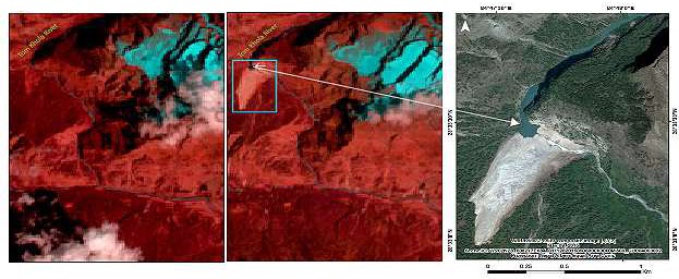
Haritashya said landslides have blocked rivers and formed lakes at many river basins in the mountainous region. With continuous aftershocks and a second major earthquake such as one on May 12, along with the fast-approaching monsoon season, Haritashya said these lakes are in danger of spilling water into remote villages.
“It is important to understand that no such major threat has been observed at this point, but it is a continuously developing story and we are keeping an eye on a daily basis,” Haritashya said.
Haritashya joined the University of Dayton’s geology department after completing a post-doctoral research appointment in NASA’s international Global Land Ice Measurements from Space project at the University of Nebraska-Omaha.
His research interests include hydropower, water resources, glaciers, climate change and the Himalayas. He is an editorial board member of the Journal of Hydrologic Engineering, The Open Hydrology Journal and Himalayan Geology. Haritashya also helped edit Encyclopedia of Snow, Ice and Glaciers.
Note : The above story is based on materials provided by University of Dayton.


