Nizhnyaya Tunguska is a river in Siberia, Russia, flows through the Irkutsk Oblast and the Krasnoyarsk Krai. The river is a right tributary of the Yenisei joining it at Turukhansk (see Siberian River Routes). Settlements on the river include Tura, Yukti and Simenga. The ice-free period on the Lower Tunguska starts in mid-June and ends in the first half of October.
Hydrography
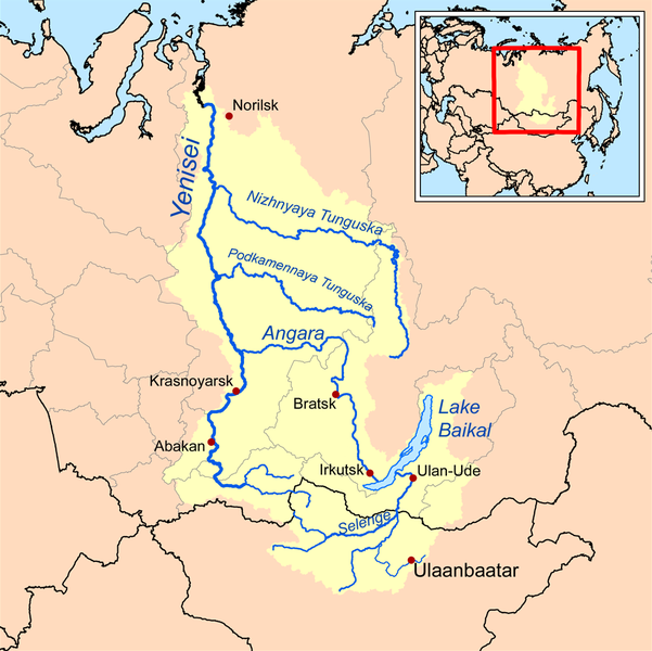
The second largest right tributary of Yenisei joins it near town Turukhansk. According character of stream, constitution of river’s valley and its shores it can be divided into two parts: the first one starts at the source of the river and continues down to village Preobrazhenskoye and the second section of the river lies downstream of this village in a canyon-like relief.
Upper stream
The first part of Lower Tunguska has length 580 km and occupies wide valley with flat slopes which is formed basically of sand and clay deposits. The speed of flow at rafts reaches 0.4-0.6 m/s and drops significantly at the stretches of river’s channel.
This section of river has meandering channel approaching closely Lena River, another great Siberian river. The minimum distance between them is as short as 15 km in the neighbourhood of town Kirensk. All the upper stream of Nizhnyaya Tunguska is in range of the Irkutsk Oblast.
Lower stream
Downstream of village Preobrazhenskoye the Lower Tunguska flows in the narrow and deep valley with high, often rocky shores. Entire landscape here has volcanic origins with plateau Putorana to the north of the river, the relief alters the flow of Nizhnyaya Tunguska to west direction. The river channel frequently has lake-like widenings with lengths up to 20 km and longer. The locations with close approaches of crystalline layers create numerous rapids on the river. The most significant of them has its names: “Sakko”, “Vivinskiy”, “Uchamsky” and “Bolshoy” (Russian: Большой, Big). The locations of rapids on the river has relatively high speeds of water flux reaching 3–5 m/s. In some places downstream of rapids the river channel becomes very deep with maximum depths 60–100 m. In the river’s lowest flow, downstream of join with its tributary river Severnaya, Nizhnyaya Tunguska runs between limestone rocks, which steeply rise from the water. The speeds of flow here grows to 1-1.5 m/s.
The channel and water flow of river’s lower stream has its own distinguishing features, which can be met in some places at Nizhnyaya Tunguska, including follows:
- The stripes of stones with sizes 10–40 cm, which stretches near water along shore line. This peculiar feature of arctic stony rivers with local name “bechevnick” is being formed during every seasonal period of ice drift and river inundation at spring. At some locations this sort of pebbles is polished and pressed together to that extent that it creates a cobbled road of its own kind.
- The slopes of river canyon during its evolution underwent stone avalanches which formed stone runs with sizes of individual rocks as big as 1.5 m in diameter. These slide-slopes has local name “korga” and create zones of calm backwater downstream.
- The stream in the channel of Lower Tunguska sometimes forms whirlpools. They originate downstream of cliffs which press the flow to the opposite shore. These whirlpools can reach depths of river floor down to 100 m deep and is most frequent during highwater periods at early summer.
Tributaries
The most significant tributaries of Nizhnyaya Tunguska are: right one — Eika, Kochechum, Yambuckan, Vivi, Tutonchana, Erachimo, Severnaya; left one – Nepa, Bolshaya Erema, Teteya, Ilimpeya, Nidym, Taymura, Uchami. The most prominent of them is Kochechum, which joins it from the north near Tura. The average annual discharge of Kochechum is 600 m3/s, the area of its basin is nearly 100,000 km².
In a whole, the right tributaries of Lower Tunguska dominate over left inflows adding a greater amount of water to the river than the left one. The river has not big lakes in its basin, the biggest lake is Vivi has surface area 229 km². Incoming amount of water to Nizhnyaya Tunguska is strongly season dependant.
Hydrology
The value of average water discharge of Lower Tunguska gives it eleventh place amongst largest rivers of Russia. The annual water discharge of river’s mouth is equal to 3,680 m3/s. The minimum value observed in 1967 was equal to 2,861 m3/s, the maximum one was 4,690 m3/s in 1974 or, respectively, for estuary of the river it corresponds to ~3,093 m3/s and ~5,070 m3/s. Water supply of the river is due to melting snow and summer rains. During winter season Lower Tunguska contains little water as its basin lies in the region of permafrost and it has not subterranean water sources. According hydrological observations during 52 years, the minimum average monthly discharge was equal to 27.8 m3/s in March 1969 — it was exceptionally dry winter — and the maximum value corresponds to June 1959 and is equal to 31,500 m3/s. The diagram below contains mean values of monthly average discharges calculated on the base of 52-year long period of observations at hydrological station “Bolshoy Porog”.
The 73 per cent of entire annual water yield corresponds to the period of spring-summer season.The amplitude of water level variations in the lower stream of Nizhnyaya Tunguska is very high and is highest among all notable rivers of Russia. The narrow places of river channel jam ice during its seasonal drift creating temporal dams which blocks normal water flow and raises water level up to 30–35 m above mean value. The summer break-up and drifting of ice passes very violently, it leaves traces in the form of torned apart uprooted trees, polished rocks etc. During some days of spring freshets the river’s discharge can peak at 74,000-112,000 m3/s and it supplies 50-60% of water volume to the lower stream of Yenisei river in the time of its seasonal inundation.
Note : The above story is based on materials provided by Wikipedia


