The Niagara River is a river that flows north from Lake Erie to Lake Ontario. It forms part of the border between the Province of Ontario in Canada (on the west) and New York State in the United States. There are differing theories as to the origin of the name of the river. According to Iroquoian scholar Bruce Trigger, “Niagara” is derived from the name given to a branch of the locally residing native Neutral Confederacy, who are described as being called the “Niagagarega” people on several late-17th-century French maps of the area. According to George R. Stewart, it comes from the name of an Iroquois town called “Ongniaahra”, meaning “point of land cut in two”.
The river, which is occasionally described as a strait, is about 56 kilometres (35 mi) long and includes Niagara Falls in its course. The falls have moved approximately 11 kilometres (6.8 mi) upstream from the Niagara Escarpment in the last 12,000 years, resulting in a gorge below the falls. Today, the diversion of the river for electrical generation has significantly reduced the rate of erosion.
Power plants on the river include the Sir Adam Beck Hydroelectric Power Stations on the Canadian side, and the Robert Moses Niagara Power Plant (built in 1961) on the American side. Together, they generate 4.4 gigawatts of electricity. The International Control Works, built in 1954, regulates the river flow. Ships on the Great Lakes use the Welland Canal, part of the Saint Lawrence Seaway, on the Canadian side of the river, to bypass Niagara Falls.
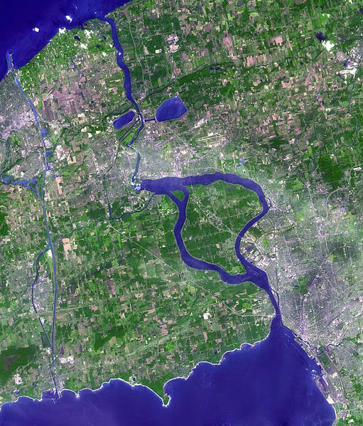
The total drop in elevation along the river is 99 metres (325 ft). The Niagara Gorge extends downstream from the Falls and includes the Niagara Whirlpool and another section of rapids.
The Niagara River also features two large islands and numerous smaller islands. Grand Island and Navy Island, the two largest islands, are on the American and Canadian sides of the river, respectively. Goat Island and the tiny Luna Island split Niagara Falls into its three sections, the Horseshoe, Bridal Veil, and American Falls. Squaw Island lies further upstream, alongside the city of Buffalo.
The Niagara River and its tributaries, Tonawanda Creek and the Welland River, formed part of the last section of the Erie Canal and Welland Canal. After leaving Lockport, New York, the Erie Canal proceeds southwest until it enters Tonawanda Creek. After entering the Niagara River, watercraft then proceed southward to the final lock, where a short section of the canal allows boats to avoid the turbulent shoal water at the river intake and enter Lake Erie.
The Welland Canals used the Welland River as a connection to the Niagara River south of the falls, allowing water traffic to safely re-enter the Niagara River and proceed to Lake Erie.
Note : The above story is based on materials provided by Wikipedia


