The University of Waterloo has unveiled a new satellite image of Antarctica, and the imagery will help scientists all over the world gain new insight into the effects of climate change.
Thanks to a partnership between the Canadian Space Agency (CSA), MacDonald, Dettwiler and Associates Ltd. (MDA), the prime contractor for the RADARSAT-2 program, and the Canadian Cryospheric Information Network (CCIN) at UWaterloo, the mosaic is free and fully accessible to the academic world and the public.
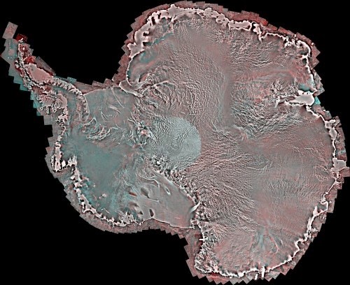
Using Synthetic Aperture Radar with multiple polarization modes aboard the RADARSAT-2 satellite, the CSA collected more than 3,150 images of the continent in the autumn of 2008, comprising a single pole-to-coast map covering all of Antarctica. This is the first such map of the area since RADARSAT-1 created one in 1997.
“The mosaic provides an update on the ever-changing ice cover in this area that will be of great interest to climatologists, geologists, biologists and oceanographers,” said Professor Ellsworth LeDrew, director of the CCIN and a professor in the Faculty of Environment at Waterloo. “When compared to the previous Antarctic RADARSAT-1 mosaic, we can map changes in the icescape with unprecedented accuracy and confidence. Earth’s polar regions are considered a bellwether for the effects of climate change.”
Professor LeDrew is at the forefront of a cultural shift in the way researchers discover, share and preserve their research data. The CCIN links international researchers around the world with numerous government, university and private organizations to provide data and information management infrastructure for the Canadian cryospheric community. This mosaic map of the Antarctic is the latest addition to the CCIN’s Polar Data Catalogue. It is available on the Polar Data Catalogue website. (https://www.polardata.ca/pdcsearch/)
“The Polar Data Catalogue’s mandate is to make such information freely available to scientists, students and the public to enhance our understanding and stewardship of the polar regions,” said Professor LeDrew. “We are proud to work with the Canadian Space Agency and MDA to bring this outstanding Canadian technology and science to the international community.”
Next up for the partnership is a similar mosaic for Greenland, which will provide further crucial information about our shifting climate in the northern hemisphere. There are also plans to continue creating mosaics of Antarctica every few years to provide more data for researchers.
Note : The above story is based on materials provided by University of Waterloo.


