
The Mackenzie River (Slavey language: Deh-Cho, big river or Inuvialuktun: Kuukpak, great river) is the largest and longest river system in Canada, and is exceeded only by the Mississippi River system in North America. It flows through a vast, isolated region of forest and tundra entirely within the country’s Northwest Territories, although its many tributaries reach into four other Canadian provinces and territories. The river’s mainstem runs 1,738 kilometres (1,080 mi) in a northerly direction to the Arctic Ocean, draining a vast area nearly the size of Indonesia. It is the largest river flowing into the Arctic from North America, and with its tributaries is one of the longest rivers in the world.
Course
Rising out of the marshy western end of Great Slave Lake, the Mackenzie River flows generally west-northwest for about 300 km (190 mi), passing the hamlets of Fort Providence and Brownings Landing. At Fort Simpson it is joined by the Liard River, its largest tributary, then swings towards the Arctic, paralleling the Franklin Mountains as it receives the North Nahanni River. The Keele River enters from the left about 100 km (62 mi) above Tulita, where the Great Bear River joins the Mackenzie. Just before crossing the Arctic Circle, the river passes Norman Wells, then continues northwest to merge with the Arctic Red and Peel rivers. It finally empties into the Beaufort Sea, part of the Arctic Ocean, through the vast Mackenzie Delta.
Most of the Mackenzie River is a broad, slow-moving waterway; its elevation drops just 156 metres (512 ft) from source to mouth. It is a braided river for much of its length, characterized by numerous sandbars and side channels. The river ranges from 2 to 5 km (1.2 to 3.1 mi) wide and 8 to 9 m (26 to 30 ft) deep in most parts, and is thus easily navigable except when it freezes over in the winter. However, there are several spots where the river narrows to less than half a kilometre (0.3 mi) and flows quickly, such as at the Sans Sault Rapids at the confluence of the Mountain River and “The Ramparts”, a 40 m (130 ft) deep canyon south of Fort Good Hope.
Watershed
At 1,805,200 square kilometres (697,000 sq mi), the Mackenzie River’s watershed or drainage basin is the largest in Canada, encompassing nearly 20% of the country. From its farthest headwaters at Thutade Lake in the Omineca Mountains to its mouth, the Mackenzie stretches for 4,241 km (2,635 mi) across western Canada, making it the longest river system in the nation and the thirteenth longest in the world. The river discharges more than 325 cubic kilometres (78 cu mi) of water each year, accounting for roughly 11% of the total river flow into the Arctic Ocean. The Mackenzie’s outflow holds a major role in the local climate above the Arctic Ocean with large amounts of warmer fresh water mixing with the cold seawater.
Many major watersheds of North America border on the drainage of the Mackenzie River. Much of the western edge of the Mackenzie basin runs along the Continental Divide. The divide separates the Mackenzie watershed from that of the Yukon River and its headstreams the Pelly and Stewart rivers, which flow to the Bering Strait; and the Fraser River and Columbia River systems, both of which run to the Pacific Ocean. Lowland divides in the north distinguish the Mackenzie basin from those of the Anderson, Horton, Coppermine and Back Rivers – all of which empty into the Arctic. Eastern watersheds bordering on that of the Mackenzie include those of the Thelon and Churchill Rivers, both of which flow into Hudson Bay. On the south, the Mackenzie watershed borders that of the North Saskatchewan River, part of the Nelson River system, which empties into Hudson Bay after draining much of south-central Canada.
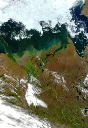
Through its many tributaries, the Mackenzie River basin covers portions of five Canadian provinces and territories – British Columbia (BC), Alberta, Saskatchewan, and the Yukon and Northwest Territories. The two largest headwaters forks, the Peace and Athabasca Rivers, drain much of the central Alberta prairie and the Rocky Mountains in northern BC then combine into the Slave River at the Peace-Athabasca Delta near Lake Athabasca, which also receives runoff from northwestern Saskatchewan. The Slave is the primary feeder of Great Slave Lake (contributing about 77% of the water); other inflows include the Taltson, Lockhart and Hay Rivers, the latter of which also extends into Alberta and BC. Direct tributaries of the Mackenzie from the west such as the Liard and Peel Rivers carry runoff from the mountains of the eastern Yukon.
The eastern portion of the Mackenzie basin is dominated by vast reaches of lake-studded boreal forest and includes many of the largest lakes in North America. By both volume and surface area, Great Bear Lake is the biggest in the watershed and third largest on the continent, with a surface area of 31,153 km2 (12,028 sq mi) and a volume of 2,236 km3 (536 cu mi). Great Slave Lake is slightly smaller, with an area of 28,568 km2 (11,030 sq mi) and containing 2,088 km3 (501 cu mi) of water, although it is significantly deeper than Great Bear. The third major lake, Athabasca, is less than a third that size with an area of 7,800 km2 (3,000 sq mi). Six other lakes in the watershed cover more than 1,000 km2 (390 sq mi), including the Williston Lake reservoir, the second-largest artificial lake in North America, on the Peace River.
With an average annual flow of 9,910 m3/s (350,000 cu ft/s), the Mackenzie River has the highest discharge of any river in Canada and is the fourteenth largest in the world in this respect. About 60% of the water comes from the western half of the basin, which includes the Rocky, Selwyn, and Mackenzie mountain ranges out of which spring major tributaries such as the Peace and Liard Rivers, which contribute 23% and 27% of the total flow, respectively. In contrast the eastern half, despite being dominated by marshland and large lakes, provides only about 25% of the Mackenzie’s discharge. During peak flow in the spring, the difference in discharge between the two halves of the watershed becomes even more marked. While large amounts of snow and glacial melt dramatically drive up water levels in the Mackenzie’s western tributaries, large lakes in the eastern basin retard springtime discharges. Breakup of ice jams caused by sudden rises in temperature – a phenomenon especially pronounced on the Mackenzie – further exacerbate flood peaks. In full flood, the Peace River can carry so much water that it inundates its delta and backs upstream into Lake Athabasca, and the excess water can only flow out after the Peace has receded.
Geology
As recently as the end of the last glacial period eleven thousand years ago the majority of northern Canada was buried under the enormous continental Laurentide ice sheet. The tremendous erosive powers of the Laurentide and its predecessors, which at maximum extent completely buried the Mackenzie River valley under thousands of meters of ice and flattened the eastern portions of the Mackenzie watershed. When the ice sheet receded for the last time, it left a 1,100 km (680 mi)-long postglacial lake called Lake McConnell, of which Great Bear, Great Slave and Athabasca Lakes are remnants. Significant evidence exists that roughly 13,000 years ago, the channel of the Mackenzie was scoured by one or more massive glacial lake outburst floods unleashed from Lake Agassiz, formed by melting ice west of the present-day Great Lakes. At its peak, Agassiz had a greater volume than all present-day freshwater lakes combined. This is believed to have disrupted currents in the Arctic Ocean and led to an abrupt 1,300-year-long cold temperature shift called the Younger Dryas.
Ecology
The Mackenzie River’s watershed is considered one of the largest and most intact ecosystems in North America, especially in the north. Approximately 63% of the basin – 1,137,000 km2 (439,000 sq mi) – is covered by forest, mostly boreal, and wetlands comprise some 18% of the watershed – about 324,900 km2 (125,400 sq mi). More than 93% of the wooded areas in the watershed are virgin forest. There are fifty-three fish species in the basin, none of them endemic. Most of the aquatic species in the Mackenzie River are descendants of those of the Mississippi River and its tributaries. This anomaly is believed to have been caused by hydrologic connection of the two river systems during the Ice Ages by meltwater lakes and channels.
Fishes in the Mackenzie River proper include the northern pike, some minnows, and lake whitefish, and the river’s shores are lined with sparse vegetation like dwarf birch and willows, as well as numerous peat dogs. Further south the tundra vegetation transitions to black spruce, aspen and poplar forest. Overall, the northern watershed is not very diverse ecologically, due to its cold climate – permafrost underlies about three-quarters of the watershed, reaching up to 100 m (330 ft) deep in the delta region – and meager to moderate rainfall, amounting to about 410 millimetres (16 in) over the basin as a whole. The southern half of the basin, in contrast, includes larger reaches of temperate and alpine forests as well as fertile floodplain and riparian habitat, but is actually home to fewer fish species due to large rapids on the Slave River preventing upstream migration of aquatic species.
Migratory birds use the two major deltas in the Mackenzie River basin – the Mackenzie Delta and the inland Peace-Athabasca Delta – as important resting and breeding areas. The latter is located at the convergence of four major North American migratory routes, or flyways. As recently as the mid-twentieth century, more than 400,000 birds passed through during the spring and up to a million in autumn. Some 215 bird species in total have been catalogued in the delta, including endangered species such as the whooping crane, peregrine falcon and bald eagle. Unfortunately, the construction of W.A.C. Bennett Dam on the Peace River has reduced the seasonal variations of water levels in the delta, causing damage to its ecosystems. Populations of migratory birds in the area have steadily declined since the 1960s.
Note : The above story is based on materials provided by Wikipedia


 is the largest and longest river system in Canada, and is)