Like an amphitheater amplifies sound, the stiff, sturdy soil beneath the Greater Vancouver metropolitan area could greatly amplify the effects of an earthquake, pushing the potential devastation past what building codes in the region are prepared for. That’s the conclusion behind a pair of studies recently coauthored by San Diego State University seismologist Kim Olsen.
Greater Vancouver sits atop a tectonic plate known as the Juan de Fuca Plate, which extends south to encompass Washington and Oregon states. The subterranean region of this plate beneath Vancouver is a bowl-shaped mass of rigid soil called the Georgia Basin. Earthquakes can and do occur in the Georgia Basin and can originate deep within the earth, between 50 and 70 kilometers down, or as shallow as a couple kilometers.
While earthquake researchers have long known that the region is tectonically active and policymakers have enforced building codes designed to protect against earthquakes, those codes aren’t quite strict enough because seismologists have failed to account for how the Georgia Basin affects a quake’s severity, Olsen said. In large part, that’s because until recently the problem has been too computationally complex, he said.
“People have neglected the effects of stiffer soil,” Olsen said. “They haven’t been able to look at the basin as a three-dimensional object.”
The idea to investigate the basin’s effect on earthquakes originated with Sheri Molnar, a postdoctoral researcher at the University of British Columbia. She reached out to Olsen, an expert in earthquake simulation, for help modeling the problem. Using supercomputer technology, Olsen has previously simulated the potential effects of a supermassive magnitude 8.0 quake in Southern California.
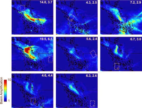
Using the same technology, Molnar and Olsen coded an algorithm to take into account the stiff-soil geography of the Georgia Basin to see how it would influence the surface effects of a magnitude 6.8 earthquake. They then ran the simulation for both a shallow and a deep quake.
In both simulations they found that the basin had an amplifying effect on motion on the surface, but the amplification was especially pronounced in shallow earthquakes. In the latter scenario, their model predicts that the sedimentary basin would cause the surface to shake for approximately 22 seconds longer than normal.
“The deep structure of the Georgia Basin can amplify the ground motion of an earthquake by a factor of three or more,” Olsen said. “It’s an irregularly shaped bathtub of sediments that can trap and amplify the waves.”
The deep and shallow studies were published today in the Bulletin of the Seismological Society of America.
Current building codes in Vancouver don’t take into account this amplification, Olsen added, meaning many buildings in the region would be in danger if a large earthquake were to hit.
Vancouver isn’t the only large metropolis built atop sedimentary basins. Los Angeles and San Francisco, too, sit on basins similar to the Georgia Basin. Olsen is currently investigating how major earthquakes along the San Andreas Fault would be affected by these basins.
He hopes that city planners can use this knowledge to update their building codes to reflect the amplifying geography beneath their feet.
“That’s always going to be the goal, to make structures safer and to mitigate the damage in the future,” Olsen said.
Note : The above story is based on materials provided by Michael Price for Seismological Society of America


