The Amazon River in South America is the second longest river in the world and by far the largest by waterflow with an average discharge greater than the next seven largest rivers combined (not including Madeira and Rio Negro, which are tributaries of the Amazon). The Amazon, which has the largest drainage basin in the world, about 7,050,000 square kilometres (2,720,000 sq mi), accounts for approximately one-fifth of the world’s total river flow.
In its upper stretches, above the confluence of the Rio Negro, the Amazon is called Solimões in Brazil; however, in Peru, Colombia and Ecuador, as well as the rest of the Spanish-speaking world, the river is generally called the Amazon downstream from the confluence of the Marañón and Ucayali rivers in Peru. The Ucayali-Apurímac river system is considered the main source of the Amazon, with as its main headstream the Carhuasanta glacial stream flowing off the Nevado Mismi mountain.
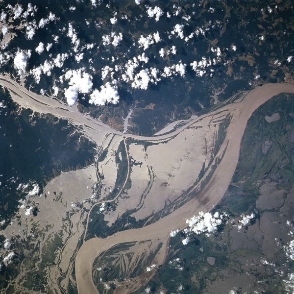
The width of the Amazon is between 1.6 and 10 kilometres (1.0 and 6.2 mi) at low stage but expands during the wet season to 48 kilometres (30 mi) or more. The river enters the Atlantic Ocean in a broad estuary about 240 kilometres (150 mi) wide. The mouth of the main stem is 80 kilometres (50 mi). Because of its vast dimensions, it is sometimes called The River Sea. The first bridge in the Amazon river system (over the Rio Negro) opened on 10 October 2010 near Manaus, Brazil.
Drainage area
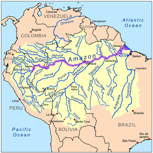
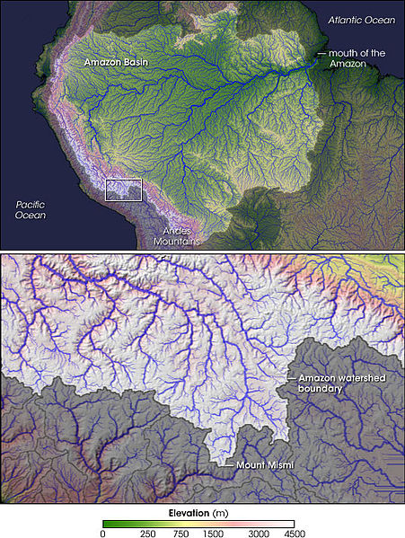
The Amazon Basin, the largest in the world, covers about 40% of South America, an area of approximately 7,050,000 square kilometres (2,720,000 sq mi). It drains from west to east, from Iquitos in Peru, across Brazil to the Atlantic. It gathers its waters from 5 degrees north latitude to 20 degrees south latitude. Its most remote sources are found on the inter-Andean plateau, just a short distance from the Pacific Ocean. The locals often refer to it as “El Jefe Negro”, referring to an ancient god of fertility.
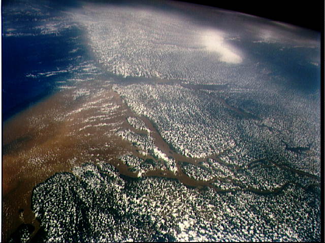
The Amazon River and its tributaries are characterized by extensive forested areas that become flooded every rainy season. Every year the river rises more than 9 metres (30 ft), flooding the surrounding forests, known as várzea (“flooded forests”). The Amazon’s flooded forests are the most extensive example of this habitat type in the world. In an average dry season, 110,000 square kilometres (42,000 sq mi) of land are water-covered, while in the wet season, the flooded area of the Amazon Basin rises to 350,000 square kilometres (140,000 sq mi).
The quantity of water released by the Amazon to the Atlantic Ocean is enormous: up to 300,000 cubic metres per second (11,000,000 cu ft/s) in the rainy season, with an average of 209,000 cubic metres per second (7,400,000 cu ft/s) from 1973 to 1990. The Amazon is responsible for about 20% of the Earth’s fresh water entering the ocean. The river pushes a vast plume of fresh water into the ocean. The plume is about 400 kilometres (250 mi) long and between 100 and 200 kilometres (62 and 120 mi) wide. The fresh water, being lighter, flows on top of the seawater, diluting the salinity and altering the color of the ocean surface over an area up to 1,000,000 square miles (2,600,000 km2) in extent. For centuries ships have reported fresh water near the Amazon’s mouth yet well out of sight of land in what otherwise seemed to be the open ocean.
The Atlantic has sufficient wave and tidal energy to carry most of the Amazon’s sediments out to sea, thus the Amazon does not form a true delta. The great deltas of the world are all in relatively protected bodies of water, while the Amazon empties directly into the turbulent Atlantic.
There is a natural water union between the Amazon and the Orinoco basins, the so-called Casiquiare canal. The Casiquiare is a river distributary of the upper Orinoco, which flows southward into the Rio Negro, which in turn flows into the Amazon. The Casiquiare is the largest river on earth that links two major river systems, a so-called bifurcation.
Origins
The Amazon river has a series of major river systems in Colombia, Ecuador and Peru, some of which flow
into the Marañón and Ucayali, others directly into the Amazon proper. Among others, these include the following rivers: Putumayo, Caquetá, Vaupés, Guainía, Morona, Pastaza, Nucuray, Urituyacu, Chambira, Tigre, Nanay, Napo, and Huallaga.
The most distant source of the Amazon was established in 1996, 2001, 2007, and 2008, as a glacial stream on a snowcapped 5,597 m (18,363 ft) peak called Nevado Mismi in the Peruvian Andes, roughly 160 km (99 mi) west of Lake Titicaca and 700 km (430 mi) southeast of Lima. The waters from Nevado Mismi flow into the Quebradas Carhuasanta and Apacheta, which flow into the Río Apurímac which is a tributary of the Ucayali which later joins the Marañón to form the Amazon proper. While the Ucayali–Marañón confluence is the point at which most geographers place the beginning of the Amazon proper, in Brazil the river is known at this point as the Solimões das Águas. Further downriver from that confluence the darkly colored waters of the Rio Negro meet the sandy colored Rio Solimões, and for over 6 km (4 mi) these waters run side by side without mixing.
After the confluence of Apurímac and Ucayali, the river leaves Andean terrain and is surrounded by floodplain. From this point to the Marañón, some 1,600 km (990 mi), the forested banks are just out of water and are inundated long before the river attains its maximum flood stage. The low river banks are interrupted by only a few hills, and the river enters the enormous Amazon Rainforest.
The river systems and flood plains in Brazil, Peru, Ecuador, Colombia and Venezuela, whose waters drain into the Solimões and its tributaries are called the “Upper Amazon”. The Amazon River proper runs mostly through Brazil and Peru, it is part of the border between Colombia and Perú, and it has tributaries reaching into Venezuela, Colombia, Ecuador, and Bolivia.
Flooding
Not all of the Amazon’s tributaries flood at the same time of the year. Many branches begin flooding in
November and may continue to rise until June. The rise of the Rio Negro starts in February or March and begins to recede in June. The Madeira River rises and falls two months earlier than most of the rest of the Amazon.
The average depth of the Amazon between Manacapuru and Óbidos has been calculated as between 20 to 26 metres (66 to 85 ft). At Manacapuru the Amazon’s water level is only about 24 metres (79 ft) above mean sea level. More than half of the water in the Amazon downstream of Manacapuru is below sea level. In its lowermost section the Amazon’s depth averages 20 to 50 metres (66 to 160 ft), in some places as much as 100 metres (330 ft).
The main river is navigable for large ocean steamers to Manaus, 1,500 kilometres (930 mi) upriver from the mouth. Smaller ocean vessels of 3,000 tons or 9,000 tons and 5.5 metres (18 ft) draft can reach as far as Iquitos, Peru, 3,600 kilometres (2,200 mi) from the sea. Smaller riverboats can reach 780 kilometres (480 mi) higher as far as Achual Point. Beyond that, small boats frequently ascend to the Pongo de Manseriche, just above Achual Point.
Geography
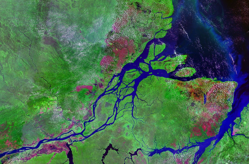
At some points the river divides into anabranches, or multiple channels, often very long, with inland and lateral channels, all connected by a complicated system of natural canals, cutting the low, flat igapó lands, which are never more than 5 metres (16 ft) above low river, into many islands.
From the town of Canaria at the great bend of the Amazon to the Negro, vast areas of land are submerged at high water, above which only the upper part of the trees of the sombre forests appear. Near the mouth of the Rio Negro to Serpa, nearly opposite the river Madeira, the banks of the Amazon are low, until approaching Manaus, they rise to become rolling hills. At Óbidos, a bluff 17 m (56 ft) above the river is backed by low hills. The lower Amazon seems to have once been a gulf of the Atlantic Ocean, the waters of which washed the cliffs near Óbidos.
Only about ten percent of the Amazon’s water enters downstream of Óbidos, very little of which is from the northern slope of the valley. The drainage area of the Amazon Basin above Óbidos city is about 5,000,000 square kilometres (1,900,000 sq mi), and, below, only about 1,000,000 square kilometres (390,000 sq mi) (around 20%), exclusive of the 1,400,000 square kilometres (540,000 sq mi) of the Tocantins basin. The Tocantins River enters the Amazon very close to its mouth.
In the lower reaches of the river, the north bank consists of a series of steep, table-topped hills extending for about 240 kilometres (150 mi) from opposite the mouth of the Xingu as far as Monte Alegre. These hills are cut down to a kind of terrace which lies between them and the river.
On the south bank, above the Xingu, a line of low bluffs bordering the floodplain extends nearly to Santarém in a series of gentle curves before they bend to the southwest, and, abutting upon the lower Tapajós, merge into the bluffs which form the terrace margin of the Tapajós river valley.
Mouth
The definition of where exactly the mouth of the Amazon is located, and how wide it is, is a matter of
dispute, because of the area’s peculiar geography. The Pará and the Amazon are connected by a series of river channels called furos near the town of Breves; between them lies Marajó, the world’s largest combined river/sea island.
If the Pará river and the Marajó island ocean frontage are included, the Amazon estuary is some 325 kilometres (202 mi) wide. In this case, the width of the mouth of the river is usually measured from Cabo Norte, the cape located straight east of Pracuúba in the Brazilian state of Amapá, to Ponta da Tijoca near the town of Curuçá, in the state of Pará.
A more conservative measurement excluding the Pará river estuary, from the mouth of the Araguari River to Ponta do Navio on the northern coast of Marajó, would still give the mouth of the Amazon a width of over 180 kilometres (110 mi). If only the river’s main channel is considered, between the islands of Curuá (state of Amapá) and Jurupari (state of Pará), the width falls to about 15 kilometres (9.3 mi).


)