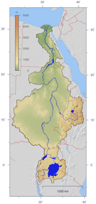
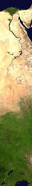
The northern section of the river flows almost entirely through desert, from Sudan into Egypt, a country whose civilization has depended on the river since ancient times. Most of the population and cities of Egypt lie along those parts of the Nile valley north of Aswan, and nearly all the cultural and historical sites of Ancient Egypt are found along riverbanks. The Nile ends in a large delta that empties into the Mediterranean Sea.
Course
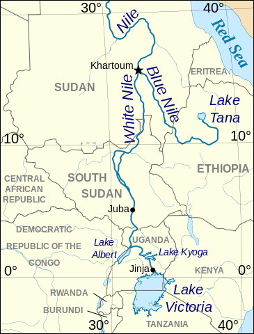
Above Khartoum the Nile is also known as the White Nile, a term also used in a limited sense to describe the section between Lake No and Khartoum. At Khartoum the river is joined by the Blue Nile. The White Nile starts in equatorial East Africa, and the Blue Nile begins in Ethiopia. Both branches are on the western flanks of the East African Rift.
The drainage basin of the Nile covers 3,254,555 square kilometres (1,256,591 sq mi), about 10% of the area of Africa. The Nile basin is complex, and because of this, the discharge at any given point along the mainstem depends on many factors including weather, diversions, evaporation and evapotranspiration, and groundwater flow.
Source
A recent exploration party went to a place described as the source of the Rukarara tributary, and by hacking a path up steep jungle-choked mountain slopes in the Nyungwe forest found (in the dry season) an appreciable incoming surface flow for many miles upstream, and found a new source, giving the Nile a length of 4199 miles (6758 kilometers)
Lost headwaters
In Uganda
The Nile leaves Lake Victoria at Ripon Falls near Jinja, Uganda, as the Victoria Nile. It flows for approximately 500 kilometres (300 mi) farther, through Lake Kyoga, until it reaches Lake Albert. After leaving Lake Albert, the river is known as the Albert Nile.
In South Sudan
It then flows into South Sudan, where it is known as the Bahr al Jabal (“Sea of the Mountain”, possibly from Nahr al Jabal, “River of the Mountain”). The Bahr al Ghazal, itself 716 kilometres (445 mi) long, joins the Bahr al Jabal at a small lagoon called Lake No, after which the Nile becomes known as the Bahr al Abyad, or the White Nile, from the whitish clay suspended in its waters. When the Nile floods it leaves a rich silty deposit which fertilizes the soil. The Nile no longer floods in Egypt since the completion of the Aswan Dam in 1970. An anabranch river, the Bahr el Zeraf, flows out of the Nile’s Bahr al Jabal section and rejoins the White Nile.
The flow rate of the Bahr al Jabal at Mongalla, South Sudan is almost constant throughout the year and averages 1,048 m3/s (37,000 cu ft/s). After Mongalla, the Bahr Al Jabal enters the enormous swamps of the Sudd region of South Sudan. More than half of the Nile’s water is lost in this swamp to evaporation and transpiration. The average flow rate of the White Nile at the tails of the swamps is about 510 m3/s (18,000 cu ft/s). From here it soon meets with the Sobat River at Malakal. On an annual basis, the White Nile upstream of Malakal contributes about fifteen percent of the total outflow of the Nile River.
In Sudan
Below Renk the White Nile enters Sudan, it flows north to Khartoum and meets the Blue Nile.
The course of the Nile in Sudan is distinctive. It flows over six groups of cataracts, from the first at Aswan to the sixth at Sabaloka (just north of Khartoum) and then turns to flow southward before again returning to flow north. This is called the Great Bend of the Nile.
In the north of Sudan the river enters Lake Nasser (known in Sudan as Lake Nubia), the larger part of which is in Egypt.
In Egypt
Below the Aswan High Dam, at the northern limit of Lake Nasser, the Nile resumes its historic course.
North of Cairo, the Nile splits into two branches (or distributaries) that feed the Mediterranean: the Rosetta Branch to the west and the Damietta to the east, forming the Nile Delta.
Tributaries
Atbara River
sea, which originates in Ethiopia north of Lake Tana, and is around 800 kilometres (500 mi) long. The Atbara flows only while there is rain in Ethiopia and dries very rapidly. During the dry period of January to June, it typically dries up. It joins the Nile approximately 300 kilometres (200 mi) north of Khartoum.
Blue Nile
The Blue Nile springs from Lake Tana in the Ethiopian Highlands. The Blue Nile flows about 1,400 kilometres to Khartoum, where the Blue Nile and White Nile join to form the Nile. Ninety percent of the water and ninety-six percent of the transported sediment carried by the Nile originates in Ethiopia, with fifty-nine percent of the water from the Blue Nile (the rest being from the Tekezé, Atbarah, Sobat, and small tributaries). The erosion and transportation of silt only occurs during the Ethiopian rainy season in the summer, however, when rainfall is especially high on the Ethiopian Plateau; the rest of the year, the great rivers draining Ethiopia into the Nile (Sobat, Blue Nile, Tekezé, and Atbarah) have a weaker flow.
The flow of the Blue Nile varies considerably over its yearly cycle and is the main contribution to the large natural variation of the Nile flow. During the dry season the natural discharge of the Blue Nile can be as low as 113 m3/s (4,000 cu ft/s), although upstream dams regulate the flow of the river. During the wet season the peak flow of the Blue Nile often exceeds 5,663 m3/s (200,000 cu ft/s) in late August (a difference of a factor of 50).
Before the placement of dams on the river the yearly discharge varied by a factor of 15 at Aswan. Peak flows of over 8,212 m3/s (290,000 cu ft/s) occurred during late August and early September, and minimum flows of about 552 m3/s (19,500 cu ft/s) occurred during late April and early May.
Bahr el Ghazal and Sobat River
The Bahr al Ghazal and the Sobat River are the two most important tributaries of the White Nile in terms of discharge.The Bahr al Ghazal’s drainage basin is the largest of any of the Nile’s sub-basins, measuring 520,000 square kilometres (200,000 sq mi) in size, but it contributes a relatively small amount of water, about 2 m3/s (71 cu ft/s) annually, due to tremendous volumes of water being lost in the Sudd wetlands.
The Sobat River, which joins the Nile a short distance below Lake No, drains about half as much land, 225,000 km2 (86,900 sq mi), but contributes 412 cubic metres per second (14,500 cu ft/s) annually to the Nile. When in flood the Sobat carries a large amount of sediment, adding greatly to the White Nile’s color.


)