The Appalachian Mountains , often called the Appalachians, are a system of mountains in eastern North America. The Appalachians first formed roughly 480 million years ago during the Ordovician Period, and once reached elevations similar to those of the Alps and the Rocky Mountains before they were eroded. The Appalachian chain is a barrier to east-west travel as it forms a series of alternating ridgelines and valleys oriented in opposition to any road running east-west.
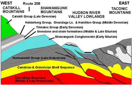
Definitions vary on the precise boundaries of the Appalachians. The United States Geological Survey (USGS) defines the Appalachian Highlands physiographic division as consisting of thirteen provinces: the Atlantic Coast Uplands, Eastern Newfoundland Atlantic, Maritime Acadian Highlands, Maritime Plain, Notre Dame and Mégantic Mountains, Western Newfoundland Mountains, Piedmont, Blue Ridge, Valley and Ridge, Saint Lawrence Valley, Appalachian Plateaus, New England province, and the Adirondack provinces. A common variant definition does not include the Adirondack Mountains, which geologically belong to the Grenville Orogeny and have a different geological history to the rest of the Appalachians.
Overview
The range is mostly located in the United States but extends into southeastern Canada, forming a zone from 100 to 300 mi (160 to 480 km) wide, running from the island of Newfoundland 1,500 mi (2,400 km) southwestward to Central Alabama in the United States. The range covers parts of the islands of Saint Pierre and Miquelon, which comprise an overseas territory of France. The system is divided into a series of ranges, with the individual mountains averaging around 3,000 ft (910 m). The highest of the group is Mount Mitchell in North Carolina at 6,684 feet (2,037 m), which is the highest point in the United States east of the Mississippi River.
The term Appalachian refers to several different regions associated with the mountain range. Most broadly, it refers to the entire mountain range with its surrounding hills and the dissected plateau region. However, the term is often used more restrictively to refer to regions in the central and southern Appalachian Mountains, usually including areas in the states of Kentucky, Tennessee, Virginia, Maryland, West Virginia, and North Carolina, as well as sometimes extending as far south as northern Georgia and western South Carolina, as far north as Pennsylvania and southern Ohio.
The Ouachita Mountains in Arkansas and Oklahoma were originally part of the Appalachians as well, but became disconnected through geologic history.
Geology of the Appalachians
Geological history
Paleozoic Era
During the earliest Paleozoic Era, the continent that would later become North America straddled the equator. The Appalachian region was a passive plate margin, not unlike today’s Atlantic Coastal Plain Province. During this interval, the region was periodically submerged beneath shallow seas. Thick layers of sediment and carbonate rock were deposited on the shallow sea bottom when the region was submerged. When seas receded, terrestrial sedimentary deposits and erosion dominated.
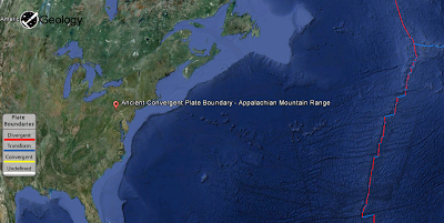
During the middle Ordovician Period (about 480-440 million years ago), a change in plate motions set the stage for the first Paleozoic mountain building event (Taconic orogeny) in North America. The once quiet Appalachian passive margin changed to a very active plate boundary when a neighboring oceanic plate, the Iapetus, collided with and began sinking beneath the North American craton. With the creation of this new subduction zone, the early Appalachians were born.
Along the continental margin, volcanoes grew, coincident with the initiation of subduction. Thrust faulting uplifted and warped older sedimentary rock laid down on the passive margin. As mountains rose, erosion began to wear them down. Streams carried rock debris downslope to be deposited in nearby lowlands.
This was just the first of a series of mountain building plate collisions that contributed to the formation of the Appalachians. Mountain building continued periodically throughout the next 250 million years (Caledonian, Acadian, Ouachita, Hercynian, and Allegheny orogenies). Continent after continent was thrust and sutured onto the North American craton as the Pangean supercontinent began to take shape. Microplates, smaller bits of crust, too small to be called continents, were swept in, one by one, to be welded to the growing mass.
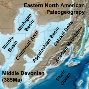
By about 300 million years ago (Pennsylvanian Period) Africa was approaching the North American craton. The collisional belt spread into the Ozark-Ouachita region and through the Marathon Mountains area of Texas. Continent vs. continent collision raised the Appalachian-Ouachita chain to a lofty mountain range on the scale of the present-day Himalaya. The massive bulk of Pangea was completed near the end of the Paleozoic Era (Permian Period) when Africa (Gondwana) plowed into the continental agglomeration, with the Appalachian-Ouachita mountains near the core.
Mesozoic Era and later
Pangea began to break up about 220 million years ago, in the Early Mesozoic Era (Late Triassic Period). As Pangea rifted apart a new passive tectonic margin was born and the forces that created the Appalachian, Ouachita, and Marathon Mountains were stilled. Weathering and erosion prevailed, and the mountains began to wear away.
By the end of the Mesozoic Era, the Appalachian Mountains had been eroded to an almost flat plain. It was not until the region was uplifted during the Cenozoic Era that the distinctive topography of the present formed. Uplift rejuvenated the streams, which rapidly responded by cutting downward into the ancient bedrock. Some streams flowed along weak layers that define the folds and faults created many millions of years earlier. Other streams downcut so rapidly that they cut right across the resistant folded rocks of the mountain core, carving canyons across rock layers and geologic structures.
More Information About :
Plate Tectonics Map
Plate Boundary Map
Note : The above story is reprinted from materials provided by Wikipedia
Plate Boundary By : USGS


