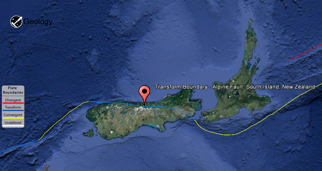
The Alpine Fault is a geological fault, specifically a right-lateral strike-slip fault, that runs almost the entire length of New Zealand’s South Island. It forms a transform boundary between the Pacific Plate and the Indo-Australian Plate. Earthquakes along the fault, and the associated earth movements, have formed the Southern Alps. The uplift to the southeast of the fault is due to an element of convergence between the plates, meaning that the fault has a significant high-angle reverse oblique component to its displacement.Transform Boundary – Alpine Fault, South Island, New Zealand The Alpine Fault is a geological fault, specifically a right-lateral strike-slip fault, that runs almost the entire length of New Zealand’s South Island. It forms a transform boundary between the Pacific Plate and the Indo-Australian Plate. Earthquakes along the fault, and the associated earth movements, have formed the Southern Alps. The uplift to the southeast of the fault is due to an element of convergence between the plates, meaning that the fault has a significant high-angle reverse oblique component to its displacement.
The Alpine Fault is believed to align with the Macquarie Fault Zone in the Puysegur Trench off the southwestern corner of the South Island. From there, the Alpine Fault runs along the western edge of the Southern Alps, before splitting into a set of smaller dextral strike-slip faults north of Arthur’s Pass, known as the Marlborough Fault System. This set of faults, which includes the Wairau Fault, the Hope Fault, the Awatere Fault, and the Clarence Fault, transfer displacement between the Alpine Fault and the Hikurangi subduction zone to the north. The Hope fault is thought to represent the primary continuation of the Alpine fault.
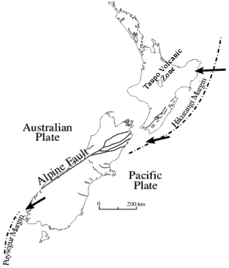
Tectonic setting of New Zealand: astride a plate boundary which includes the Alpine Fault
New Zealand lies at the edge of both the Australian and Pacific tectonic plates. To the northeast of New Zealand, and underneath North Island, the Pacific Plate is moving towards, and being subducted below the Australian Plate. To the south of New Zealand, and underneath Fiordland, the two plates are also moving toward each other but here the Australian Plate is being subducted under the Pacific Plate.
 The Australian and Pacific Plates generally don’t move smoothly past each other. They move in a series in a small rapid motions each of which is accompanied by one or more earthquakes.
Deep earthquakes under North Island form a well defined band (seismic zone) running northeast from Marlborough through White Island. Shallow earthquakes tend to occur to the southeast of this seismic zone, while the deeper ones occur towards the northwest. The earthquakes form this pattern occur where the Pacific Plate is being subducted under the Australian Plate. This pattern of deeper earthquakes towards the northwest of North Island reflects the northwest dip (or slope) of the boundary between the two plates (the Benioff zone).
Conversely, in the southwest of South Island where the Australian Plate is being subducted below the Pacific Plate, the deeper earthquakes occur on the southeast edge of the seismic zone where the Benioff zone dips steeply to the southeast.
Volcanoes
As the Pacific Plate is subducted below North Island, the part of the Australian Plate that makes up the central North Island is stretched and has, over many millions of years, become thinner than normal crust. Water released from the Pacific Plate deep under North Island combines with the hot rock of the Australian Plate at about 100km depth and causes a small amount of that rock to melt. This molten rock rises to the surface through the thinned crust and is either erupted from volcanoes like Ruapehu, Tongariro and Ngaruhoe or sits within the crust and heats it, and the water it contains, up causing geothermal activity around Taupo and Rotorua. The area of volcanic activity is referred to as the Taupo Volcanic Zone (see map above).
South Island Faults
 very large faults that run through Marlborough (Marlborough Fault System) and down the west coast of South Island (Alpine Fault). The Marlborough Fault System is a series of subparallel strike-slip faults which run northeast-southwest. Relative movement across the Marlborough Fault System is dextral or right-lateral.
Note : The above story is reprinted from materials provided by Wikipedia & Department of Geology, University of Otago, New Zealand
Plate Boundary By : USGS


