An international team led by research scientist Essam Heggy of NASA’s Jet Propulsion Laboratory, Pasadena, California, recently traveled to northern Kuwait to map the depth and extent of aquifers in arid environments using an airborne sounding radar prototype. The 40-megahertz, low-frequency sounding radar was provided by the California Institute of Technology in Pasadena; and the Institut de Physique du Globe de Paris, France. Heggy’s team was joined by personnel from the Kuwait Institute for Scientific Research (KISR), Kuwait City.
Mapping Subsurface Aquifers by Helicopter
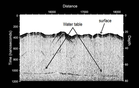
For two weeks, the team flew a helicopter equipped with the radar on 12 low-altitude passes (1,000 feet, or 305 meters) over two well-known freshwater aquifers, probing the desert subsurface down to the water table at depths ranging from 66 to 213 feet (20 to 65 meters). The researchers successfully demonstrated that the radar could locate subsurface aquifers, probe variations in the depth of the water table, and identify locations where water flowed into and out of the aquifers.
“This demonstration is a critical first step that will hopefully lead to large-scale mapping of aquifers, not only improving our ability to quantify groundwater processes, but also helping water managers drill more accurately,” said Muhammad Al-Rashed, director of KISR’s Division of Water Resources.
How Radar Sounding Works
The radar is sensitive to changes in electrical characteristics of subsurface rock, sediments and water- saturated soils. Water-saturated zones are highly reflective and mirror the low-frequency radar signal. The returned radar echoes explored the thick mixture of gravel, sand and silt that covers most of Kuwait’s northern desert and lies above its water table.
The team created high-resolution cross sections of the subsurface, showing variations in the fresh groundwater table in the two aquifers studied. The radar results were validated with ground measurements performed by KISR.
“This research will help scientists better understand Earth’s fossil aquifer systems, the approximate number, occurrence and distribution of which remain largely unknown,” said Heggy. “Much of the evidence for climate change in Earth’s deserts lies beneath the surface and is reflected in its groundwater. By mapping desert aquifers with this technology, we can detect layers deposited by ancient geological processes and trace back paleoclimatic conditions that existed thousands of years ago, when many of today’s deserts were wet.”
Climate Change Data from Desert Regions
Mars Water-Mapping Technology
Conditions in Kuwait Support Mapping
Mapping Aquifers in Hyper-Arid Regions
“Results of this study pave the way for potential airborne mapping of aquifers in hyper-arid regions such as the Sahara and Arabian Peninsula, and can be applied to design concepts for a possible future satellite mission to map Earth’s desert aquifers,” said Craig Dobson, program officer for Geodetic Imaging and Airborne Instrument Technology Transition programs at NASA Headquarters, Washington. The work is a pathfinder for the Orbiting Arid Subsurface and Ice Sheet Sounder (OASIS), a NASA spacecraft mission concept designed to map shallow aquifers in Earth’s most arid desert regions and measure ice sheet volume, thickness, basal topography and discharge rates.
Research Support
The study was co-funded by the California Institute of Technology’s Keck Institute for Space Studies and KISR. The Kuwaiti Police Air Force provided technical support for the flight tests.
JPL is managed for NASA by the California Institute of Technology in Pasadena.


